
Regulations Amending the Metal and Diamond Mining Effluent Regulations: SOR/2024-162
Canada Gazette, Part II, Volume 158, Number 16
Registration
SOR/2024-162 July 19, 2024
FISHERIES ACT
P.C. 2024-883 July 18, 2024
Her Excellency the Governor General in Council, on the recommendation of the Minister of the Environment, makes the annexed Regulations Amending the Metal and Diamond Mining Effluent Regulations under subsection 36(5) of the Fisheries Act footnote a.
Regulations Amending the Metal and Diamond Mining Effluent Regulations
Amendment
| Item | Column 1 Water or Place |
Column 2 Description |
|---|---|---|
| 80 | All waters located within the area described in column 2, located approximately 7 km northeast of Marathon, Ontario | The waters located within an area located approximately 7 km northeast of the town of Marathon, Ontario. More precisely, the area bounded by four straight lines connecting four points starting at the point located at 48°46′29.36″ north latitude and 86°21′52.45″ west longitude to the point located 1560 m northeast at 48°46′36.39″ north latitude and 86°20′36.72″ west longitude to the point located 423 m south at 48°46′22.74″ north latitude and 86°20′34.70″ west longitude to the point located 1683 m west at 48°46′19.09″ north latitude and 86°21′56.95″ west longitude and ending at the point located 330 m northeast at 48°46′29.36″ north latitude and 86°21′52.45″ west longitude. |
| 81 | All waters located within the area described in column 2, located approximately 10 km northeast of Marathon, Ontario | The waters located within an area located approximately 10 km northeast of the town of Marathon, Ontario. More precisely, the area bounded by six straight lines connecting six points starting at the point located at 48°47′56.14″ north latitude and 86°18′27.43″ west longitude to the point located 797 m east at 48°47′56.19″ north latitude and 86°17′48.26″ west longitude to the point located 393 m south at 48°47′44.11″ north latitude and 86°17′54.44″ west longitude to the point located 480 m west at 48°47′40.81″ north latitude and 86°18′17.41″ west longitude to the point located 722 m southwest at 48°47′19.25″ north latitude and 86°18′31.12″ west longitude to the point located 435 m west at 48°47′18.87″ north latitude and 86°18′52.38″ west longitude and ending at the point located 1260 m northeast at 48°47′56.14″ north latitude and 86°18′27.43″ west longitude. |
| 82 | A portion of an unnamed tributary to Angler Creek, Ontario | A portion of an unnamed tributary to Angler Creek, located approximately 7 km northeast of the town of Marathon, Ontario. More precisely, the portion extending southwest for a distance of 460 m from the point located at 48°46′49.10″ north latitude and 86°21′02.45″ west longitude to the point located at 48°46′36.87″ north latitude and 86°21′11.22″ west longitude. |
| 83 | A portion of an unnamed tributary to Pic River, Ontario | A portion of an unnamed tributary to Pic River approximately 7 km northeast of the town of Marathon, Ontario. More precisely, the portion extending eastwards for a distance of 655 m from the point located at 48°46′28.86″ north latitude and 86°19′29.07″ west longitude to the point located at 48°46′28.23″ north latitude and 86°19′58.54″ west longitude. |
Coming into Force
2 These Regulations come into force on the day on which they are registered.
REGULATORY IMPACT ANALYSIS STATEMENT
(This statement is not part of the Regulations.)
Executive summary
Issues: Generation PGM Inc. (the Proponent) proposes to construct, operate and decommission an open pit platinum group metal and copper mine. The mine will be located approximately 10 km from the Town of Marathon, Ontario. To manage the waste generated by the mining operations, the Proponent will construct a Tailings Storage Facility (TSF) and Mine Rock Storage Area (MRSA) that will destroy 10 water bodies that are frequented by fish. The Fisheries Act prohibits the deposit of deleterious substances into waters frequented by fish, unless it is authorized by regulation. The Metal and Diamond Mining Effluent Regulations (MDMER) include provisions to allow, under certain conditions, the disposal of mine waste in waters frequented by fish.
Description: The Regulations Amending the Metal and Diamond Mining Effluent Regulations (the amendments) will list two water bodies and two geographical areas encompassing eight water bodies to Schedule 2 of the MDMER, designating them as tailings impoundment areas and authorizing their destruction for the purpose of the disposal of mine waste. These 10 water bodies will represent a loss of 3.66 hectares (ha) of fish habitat.
Rationale: The Proponent assessed several options to determine the preferred disposal method and site location to manage mine waste,footnote 2 taking into account environmental, technical, economic and socio-economic factors. The Proponent prepared an assessment of alternatives reports in accordance with the Department of the Environment’s Guidelines for the assessment of alternatives for mine waste disposal. The selected site for the TSF received the highest technical and socio-economic ratings and was rated the highest overall. The selected site for the MRSA received the highest environmental, economic and socio-economic ratings and was rated highest overall. The key determinants of these results were water resources, protection of the Biigtig Zibi (Pic River), public safety and operational complexity.
The MDMER requires that the Proponent develop and implement a fish habitat compensation plan (FHCP) to offset the loss of fish habitat resulting from the disposal of mine waste in waters frequented by fish. The Proponent must provide a letter of credit or an equivalent financial guarantee to cover the cost of implementation of the FHCP, which is estimated at 1.9 million dollarsfootnote 3 over a 10-year period. The implementation of the FHCPfootnote 4 will result in the creation of 11.74 ha of fish habitat, which is more habitat than the loss associated with the destruction of the 10 water bodies to be listed on Schedule 2 of the MDMER.
Issues
The Proponent, Generation PGM Inc., proposes the development of an open pit platinum group metal and copper mine located approximately 10 km from the Town of Marathon, Ontario. The disposal of mine waste generated by the mining operations will destroy 10 water bodies frequented by fish, for a total of 3.66 hectares (ha) of fish habitat. Subsection 36(3) of the Fisheries Act (the Act) prohibits the deposit of deleterious substances into waters frequented by fish, unless it is authorized by regulation. The Metal and Diamond Mining Effluent Regulations (MDMER) include provisions to allow, under certain conditions, for the disposal of mine waste in waters frequented by fish. For the Proponent to be able to dispose of mine waste in waters frequented by fish, the water bodies must first be listed in Schedule 2 of the MDMER.
Background
Metal and Diamond Mining Effluent Regulations (MDMER)
The MDMER, which came into force on June 1, 2018,footnote 5 prescribe in Schedule 4 the maximum authorized limits for deleterious substances in mine effluent (i.e. arsenic, copper, cyanide, lead, nickel, zinc, radium-226, un-ionized ammonia and total suspended solids). The MDMER also specify the allowable pH range of mine effluent and require that mine effluent not be acutely lethal to fish.footnote 6 Therefore, effluent deposited from any final discharge point of a mine subject to the MDMER, including effluent from tailings impoundment areas (TIA), must comply with the authorized limits for the deleterious substances and meet the other conditions set out in the MDMER. Moreover, the MDMER require that mine owners and operators sample and monitor effluent to ensure compliance with the authorized limits and to determine any impact on fish, fish habitat and fishery resources. The Department of the Environment (the Department) publishes annual performance summaries for mines with respect to the prescribed limits and various requirements of the MDMER.
The use of water bodies frequented by fish for mine waste disposal can only be authorized through an amendment to the MDMER by listing these water bodies in Schedule 2, designating them as a TIA. As of June 2024, 75 water bodies or geographical areas were listed in Schedule 2 of the MDMER. Section 27.1 of the MDMER requires the development and implementation of a fish habitat compensation plan (FHCP) to offset the loss of fish habitat that would occur as a result of the use of fish-frequented water bodies for mine waste deposits. The FHCP must be approved by the Minister of the Environment before any mine waste is deposited into the relevant water bodies. The owner or operator of a mine is also required to submit an irrevocable letter of credit or an equivalent financial guarantee to ensure that funds are in place should the owner or operator fail to address all the elements of the FHCP.
For any project where the proposed mine waste disposal (including effluent) would affect fish-frequented waters, mine owners or operators must consider options for mine waste disposal and demonstrate that the preferred option is the best option based on environmental, technical, economic and socio-economic criteria specified in the Department’s Guidelines for the assessment of alternatives for mine waste disposal.
Marathon Palladium Project
The Proponent proposes to develop an open pit platinum group metal and copper mine located approximately 10 kilometres (km) from the Town of Marathon, Ontario (Figure 1). The Project mine site is located on land claimed by Biigtigong Nishnaabeg as their Exclusive Title Area. Other Indigenous communities in proximity to the Project are the Ginoogaming First Nation, Jackfish Metis Association, Long Lake #58 First Nation, MĂ©tis Nation of Ontario, Michipicoten First Nation, Netmizaaggamig Nishnaabeg, Pays Plat First Nation and Red Sky MĂ©tis Independent Nation. The Project will include three open pits, an onsite ore processing facility, a 115 kilovolts (kV) transmission line, an access road, a Mine Rock Storage Area (MRSA), a Tailings Storage Facility (TSF), a water management system, and an explosives production plant and associated storage area. Offsite infrastructure includes an employee accommodation complex and a potential rail load-out facility.
The Project will consist of three phases: a construction phase of approximately 18–24 months, an operations phase of approximately 12.7 years, and a decommissioning and closure phase of approximately 50 years. Active closure activities will occur in the first five years and passive and post-closure activities will last 45 years. The Project is expected to generate 330 million tonnes (Mt) of mine rock and 117 Mt of tailings over its lifetime.
Figure 1: Location of the Marathon Palladium Project
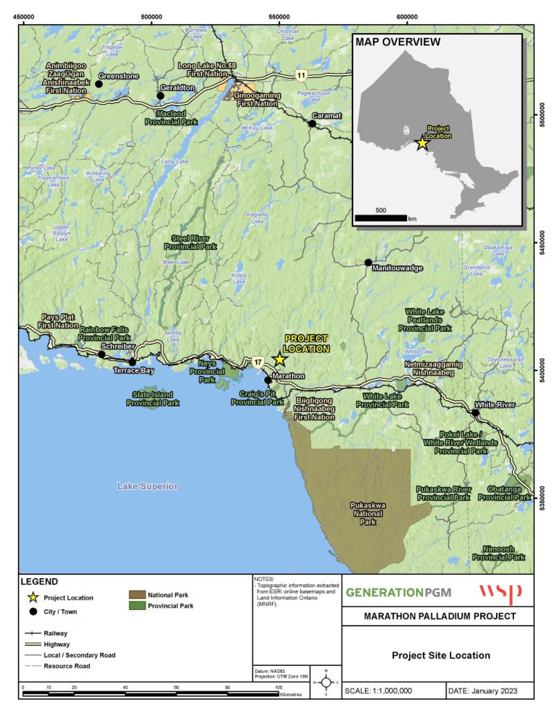
Figure 1: Location of the Marathon Palladium Project - Text version
The top right-hand corner of the figure shows a smaller map of the province of Ontario. The map inset shows the outline of Ontario with a yellow star indicating the location of the project on the main map.
The main figure shows the enlarged area at a scale of 1:1,000,000 indicating the general location of the Marathon Palladium project in Ontario in the middle of the map, marked with a yellow star. The project is located north of the town of Marathon, near the northwest shore of Lake Superior, in Ontario. The map shows the location of the project in relation to major cities, which include Marathon to the south, Terrace Bay and Schreiber to the west, Manitouwadge to the North, and White River to the east. The Trans-Canada Highway, Highway 17, crosses the map laterally and links towns such as Schreiber, Terrace Bay, Marathon and White River, west to east. Other important routes include Highway 11, which also crosses the top of the map laterally, and secondary roads that lead to various small communities and natural resource sites.
The legend located at the bottom of the figure describes the symbols used to indicate features on the map, including the project location, city/towns, railways, highways, local/secondary roads, resource roads, national parks, and provincial parks.
Management of mine waste at the Marathon Palladium Project
The waste generated from the Marathon Palladium Project will be comprised of non-potentially acid-generating (NAG) and potentially acid-generating (PAG) tailings, NAG and PAG mine rock, and overburden. Mineralogy and geochemical testing indicated that 85% to 90% of the mine rock is NAG, with some intended to be repurposed as construction materials and the remainder to be stored in the MRSA. The remaining 10% to 15% is estimated to be PAG mine rock and will be screened out and stored in the TSF. To reduce the storage requirements of the TSF, approximately 4.3 Mt of tailings will be stored in the Central Pit near the end of operations. The proposed mine plan therefore includes the development of the following facilities and infrastructure.
Tailings Storage Facility (TSF)
The TSF is a multi-cell facility that consists of two combined cells divided by a lined rock-fill embankment and a water management pond (WMP). The TSF will store approximately 134 Mt of thickened tailings and mine rock, as well as 3 million metres cubed (Mm3) of water over a total footprint of 356 ha. NAG tailings will be stored in Cells 1 and 2. The PAG tailings and mine rock will be stored in Cell 2 and overlain with NAG tailings prior to the closure of the site. Seepage collection basins will be constructed around the TSF to collect seepage and runoff in order to protect the downstream Angler Creek mainstem and other nearby water bodies. The WMP will be used to temporarily manage site contact and process water. Reclaim and runoff water will be transferred from Cell 2 to Cell 1 by gravity. Water will be reclaimed from Cell 1 and the WMP to be used in ore processing. Excess water will be treated and discharged by pipeline to Hare Lake.
A Storm Water Management Pond (SWMP) will be constructed downstream/down catchment of the mine site to manage stormwater runoff. The SWMP will be one of the first facilities to be constructed and will be used to manage contact water during the construction phase, which will take place before the construction of the WMP. Water from the SWMP will be pumped to the WMP.
The TSF and the SWMP will result in the loss of 2.89 ha of fish habitat.
Mine Rock Storage Area (MRSA)
The MRSA has a designed capacity to store 330 Mt of mine rock and will have an overall footprint of approximately 180 ha. During operations, excavated NAG rock will be stored in the MRSA or used for construction. Contact water from the MRSA will be collected via a combination of sumps and catch basins, perimeter ditching and pumping, and then pumped to the WMP. During the closure phase, the MRSA will be regraded as necessary and flat surfaces will be revegetated. Sumps will redirect contact water from the MRSA to the open pit.
The MRSA will result in the loss of 0.77 ha of fish habitat.
The disposal of mine waste at the TSF and the MSRA will destroy 10 water bodies or portions of water bodies that are frequented by fish, totalling approximately 3.66 ha of fish habitat.
Environmental assessment of the Marathon Palladium Project
The Project was subject to both a provincial class environmental assessment under Ontario’s Environmental Assessment Act (the EAA) and a federal environmental assessment (EA) under the now repealed Canadian Environmental Assessment Act, 2012 (the CEAA, 2012). The Project was assessed by a Joint Review Panel established by the federal Minister of the Environment and the provincial Minister of the Environment in accordance with the Canada-Ontario Agreement on Environmental Assessment Cooperation (2004).
On November 30, 2022, the Minister of the Environment issued an EA Decision Statement indicating that the Project is not likely to cause significant adverse environmental effects referred to in subsections 5(1) and (2) of the former CEAA, 2012. The Decision Statement issued by the Minister sets out 269 legally binding conditions to protect the environment, including mitigation measures and follow-up program requirements.
On November 7, 2023, the province of Ontario accepted and filed the Closure Plan as a document complying with the requirements of Ontario Regulation 240/00: Mine Development and Closure Under Part VII of the Act.
The Proponent also requests authorization under paragraph 35(2)(b) of the Fisheries Act. This authorization, if issued, would allow the carrying on of a work, undertaking or activity that results in the death of fish by means other than fishing and the harmful alteration, disruption, or destruction of fish habitat.
Objective
The objective of the Regulations Amending the Metal and Diamond Mining Effluent Regulations (the amendments) is to authorize the deposit of mine waste generated by the Marathon Palladium Project into certain fish-frequented water bodies under subsection 5(1) of the MDMER, subject to prescribed conditions.
Description
The amendments will list two water bodies and two geographical areas encompassing eight water bodies in Schedule 2 of the MDMER (see Figure 2), designating them as TIAs and authorizing their use for the disposal of mine waste. This will result in the loss of 3.66 ha of fish habitat.
Figure 2: Location of water bodies to be listed in Schedule 2 of the MDMER
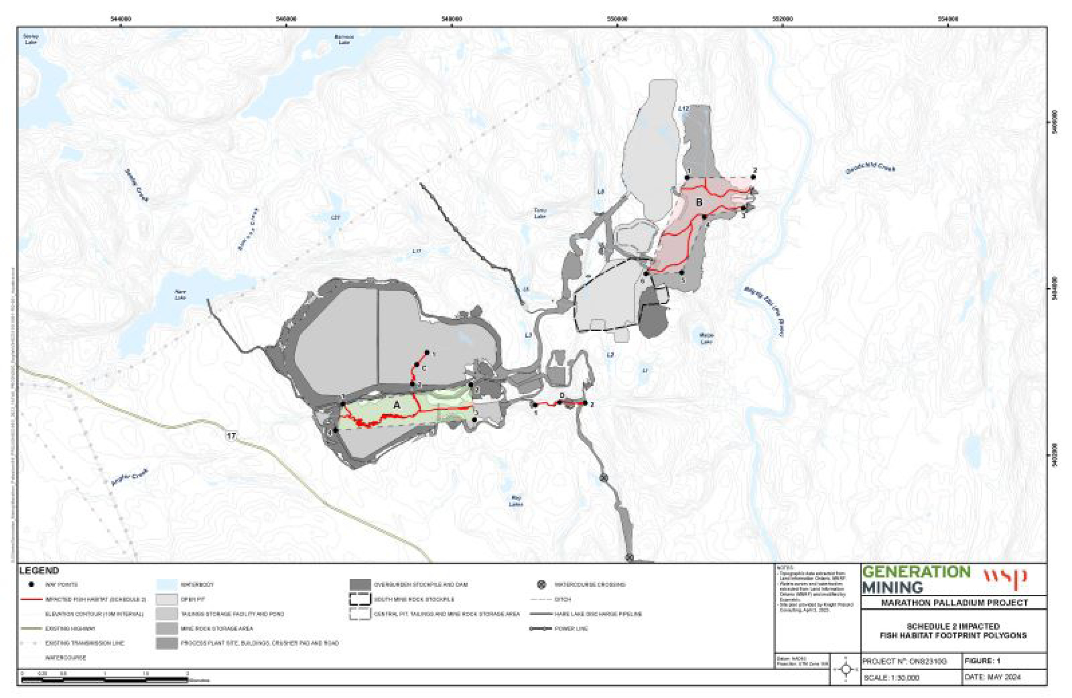
Figure 2: Location of water bodies to be listed in Schedule 2 of the MDMER - Text version
The figure shows a map of the Marathon Palladium Project site at a scale of 1:30,000. The waterbodies to be listed in Schedule 2 of the Metal and Diamond Mining Effluent Regulations (MDMER) are highlighted in red. Mine infrastructure, including the open pits, tailings storage facility and pond, mine rock storage area, process plant site, buildings, crusher pad, overburden stockpile and dam are shown in varying shades of grey.
Two geographical areas being listed in Schedule 2 of the MDMER are labelled A and B. Geographic area A is located southwest of the text-center of the map, immediately south of the tailings storage facility. Geographic area A contains five impacted water bodies bounded by an irregular polygon with four straight lines connected by four waypoints numbered 1 to 4. Geographic area B is located northeast of the centre of the map, and east of the open pits. Geographic area B contains three impacted water bodies bounded by an irregular polygon with six straight sides connected by six waypoints labelled 1 to 6.
Two individual waterbodies being listed on Schedule 2 of the MDMER are labelled C and D and are identified by numbered waypoints. The individual water body labelled C extends south from the middle of the right cell of the tailings storage facility and is connected by two waypoints. The individual waterbody labelled D extends eastwards beginning just east of the tailings storage facility and pond, and is connected by two waypoints.
A legend at the bottom of the figure describes the symbols used to indicate features on the map, including waypoints, impacted fish habitat (schedule 2 of the MDMER), elevation contours (10 metre interval), existing highways, existing transmissions lines, watercourses, water bodies, open pits, tailings storage facility and pond, mine rock storage area, process plant site buildings, crusher pad and roads, overburden stockpiles and dam, south mine rock stockpiles, central pit tailings and mine rock storage area, watercourse crossings, ditches, Hare Lake discharge pipeline, and power lines.
Regulatory development
Consultation
On October 30, 2023, the Department launched public and Indigenous consultations on the amendments to Schedule 2 for the Project. A consultation website was published with the link to the main document on which the Department consulted, namely the FHCP prepared by the Proponent to offset the loss of fish habitat resulting from the disposal of mine waste. A link to the assessment of alternatives report, prepared by the Proponent in accordance with the Department’s Guidelines for the assessment of alternatives for mine waste disposal, was also published. This assessment of alternatives was conducted and consulted on throughout the federal environmental assessment. The water bodies that will be impacted by the disposal of mine waste were considered during the environmental assessment and, as a result, the Department was consulted only on the FHCP. The consultation website was open from October 30 to December 30, 2023.
A virtual public consultation period was open from October 30 to December 30, 2023. Details of the amendments and how to submit comments were published on a consultation page. To promote the consultations on the amendments, the Department advertised the opportunity to provide comments on the FHCP via a series of social media posts on the Department’s official Facebook, LinkedIn and X accounts. A public notice was placed in three weekly issues of the Marathon Mercury and posted on the official website for the Town of Marathon.
During the 60-day public comment period, several general comments were received from the public on the environmental impacts of the mine, but none specific to the amendment of Schedule 2 or the FHCP. The Department acknowledged receipt of the comments; however, issues related to environmental impacts were addressed as part of the Joint Review Panel of the Project and no further action was needed from the Department.
The amendments are exempt from prepublication in the Canada Gazette, Part I, per the Department’s policy on Streamlining the approvals process for metal mines with tailings impoundment areas. This policy includes the conditions that must be met for an exemption from prepublication to be considered by the Governor in Council, which include the completion of public and Indigenous consultations on the amendments and a determination, based on the environmental assessment, that the project is not likely to cause significant adverse environmental effects, taking into account the implementation of appropriate mitigation measures. The federal environmental assessment, which was conducted by a Joint Review Panel and approved on November 30, 2023, considered public and Indigenous peoples’ comments on the options for tailings and waste rock management facilities through an assessment of alternatives. The federal environmental assessment concluded that, taking into account the implementation of appropriate mitigation measures, the project is not likely to cause adverse environmental effects. Furthermore, the Department consulted with the public and Indigenous peoples on the FHCP between October 2023 and April 2024. The details of the consultations related to the amendments are provided in the consultation section of this document.
Modern treaty obligations and Indigenous engagement and consultation
An assessment of modern treaty implications conducted in accordance with the Cabinet Directive on the Federal Approach to Modern Treaty Implementation concluded that the amendments will not impact modern treaty rights or obligations.
Indigenous communities within or near the Project area, whose rights might be adversely impacted, were identified and consulted during the federal EA process and during the regulatory development phase related to these amendments. Local and traditional knowledge about the Project locations were considered in the identification of potential environmental effects.
During the federal EA process, the Impact Assessment Agency of Canada (the Agency) undertook an assessment of potential impacts on Indigenous and treaty rights related to current traditional land use and practice of rights and considered all information provided by Indigenous peoples in selecting the preferred site for the TSF and MRSA.
Considering the concerns and interests that have been identified in the federal environmental assessment and consultation processes, the Agency is of the view that with the conditions established in the Decision Statement, the concerns and interests of Indigenous groups are appropriately accommodated for the purpose of issuing decision-making under the former CEAA, 2012.
The Department consulted with the Indigenous communities within or near the Project area that may be adversely impacted by the amendments. Between July and October 2023, in collaboration with the Agency and the Department of Fisheries and Oceans (DFO), the Department met with interested Indigenous communities within or near the Project area who had participated in consultations during the federal EA process to discuss the regulatory and permitting phase for the Project. In October 2023, the Department formally engaged with Indigenous communities in collaboration with DFO. Written communications were sent by email to the Indigenous communities potentially impacted by the Project, including Biigtigong Nishnaabeg, Ginoogaming First Nation, Jackfish Metis Association, Long Lake #58 First Nation, MĂ©tis Nation of Ontario, Michipicoten First Nation, Pays Plat First Nation, Pic Mobert First Nation and Red Sky MĂ©tis Independent Nation. Four Indigenous communities responded that they would like to participate in consultations: Ginoogaming First Nation, Long Lake #58 First Nation, MĂ©tis Nation of Ontario and Red Sky MĂ©tis Independent Nation. Between October 2023 and April 2024, the Department and DFO met with each of these Indigenous communities to determine a path forward regarding regulatory consultations, ask them to conduct a technical review of the FHCP, discuss their comments from this review and provide responses to their technical comments. Capacity funding to participate in the consultations and provide written comments on the FHCP related to the amendments was provided by the Agency to the Indigenous communities who requested it.
Consultation with Biigtigong Nishnaabeg
On September 7, 2023, the Department and DFO met virtually with Biigtigong Nishnaabeg for an introductory meeting to explain the regulatory process for amending Schedule 2. No concerns about the Project were raised during the meeting. On September 13, 2023, Biigtigong Nishnaabeg shared a letter with the Department in support of the amendments. The letter also states that Biigtigong Nishnaabeg has an agreement with the Proponent that includes the ongoing sharing of information and consultation on various plans and permits, and that they have no further concerns.
Consultation with the Ginoogaming First Nation
On November 2, 2023, in response to the communication sent by the Department, the Ginoogaming First Nation indicated that they would like to participate in discussions on the FHCP. On November 7, 2023, the Ginoogaming First Nation accepted capacity funding to review the proposed FHCP, and on February 27, 2024, the Ginoogaming First Nation submitted a letter indicating the following concerns with the FHCP:
- the Ginoogaming First Nation would like to ensure the ability of community members to continue their use of Ramsay Lake for traditional purposes, which is located within the trapline of a community member, and requested regular updates on the work in the area;
- the Ginoogaming First Nation asked the Proponent to consider additional like-for-like measures, such as improving and creating stream habitat, that would directly benefit its community members.
In response to the Ginoogaming First Nation’s letter, the Proponent committed to keeping the Ginoogaming First Nation and members updated on the start dates and progress of the work at Ramsay Lake. The Proponent also confirmed that the work will not interfere with the trapline owners’ ability to trap in the area. The Proponent also committed to consulting with the Ginoogaming First Nation on additional like-for-like measures being evaluated to replace impacted stream habitat. These additional in-kind measures will be addressed as part of the ongoing work on the Fisheries Act section 35 authorization.
Consultation with the Jackfish Metis Association
On August 15, 2023, the Department and DFO met virtually with the Jackfish Metis Association for an introductory meeting to explain the regulatory amendment process to list waters frequented by fish in Schedule 2 of the MDMER. During the meeting, the Jackfish Metis Association indicated that they had been meeting regularly with the Proponent to discuss the Project and that the Project’s impacts on fish will not affect harvesting practices for community members. The Jackfish Metis Association expressed satisfaction that the Pic River and Bamoos Lake will not be affected by the Project.
In response to the written communication sent in October 2023 to formally launch consultations on the amendments, the Jackfish Metis Association indicated they are pleased with the Proponent’s continued consultations with the Jackfish Metis Community related to the Project and that they do not wish to participate in the government’s consultation process. The Jackfish Metis Association also expressed frustration that consultations related to the Project are ongoing and are impeding the opening of the mine.
Consultation with the Long Lake #58 First Nation
On October 27, 2023, the Long Lake #58 First Nation responded to the Department’s formal written communication indicating that they would like to be consulted on the amendments and the FHCP. On January 22, 2024, the Long Lake #58 First Nation accepted capacity funding to participate. On January 26, 2024, the Department and DFO met virtually with the Long Lake #58 First Nation to discuss the amendment process and the Fisheries Act authorization. On March 15, 2024, another meeting took place with the Proponent to discuss the FHCP. On April 5, 2024, the Long Lake #58 First Nation sent an email indicating that they supported the Ginoogaming First Nation’s concerns around the use of Ramsay Lake and the need for additional like-for-like measures. The Department shared the response to Ginoogaming First Nation’s concerns prepared by the Proponent with the Long Lake #58 First Nation. The Long Lake #58 First Nation did not share any further concerns.
Consultation with the MĂ©tis Nation of Ontario
On August 2, 2023, the Department and DFO met virtually with the Métis Nation of Ontario for an introductory meeting to explain the amendment process to list waters frequented by fish in Schedule 2 of the MDMER and the Fisheries Act authorization. At the meeting, the Métis Nation of Ontario expressed concern with the critical minerals strategy, particularly regarding the Project timelines. In response to the written communication sent in October 2023 to formally launch consultations, the Métis Nation of Ontario indicated they would like to engage in discussions on the FHCP. On November 7, 2023, the Métis Nation of Ontario accepted capacity funding to participate in consultations and to review the FHCP. Between November 2023 and April 2024, the Department and DFO met several times with the Métis Nation of Ontario’s technical staff and the Métis Nation of Ontario Region 2 Consultation Committee (R2CC).
The Métis Nation of Ontario expressed that they were not consulted in the selection of Ramsay Lake as a compensation measure. They are of the view that Ramsay Lake is too far from the Project and that compensation in this lake does not benefit Region 2 members. Furthermore, the Métis Nation of Ontario indicated that the current ratio of like-for-like habitat in the plan is insufficient to present a net gain to the Métis Nation of Ontario Region 2 for the exercise of rights and interests, and that they would like to see the creation of stream habitat as part of the offsetting measures. As part of the development of the FHCP, the Proponent solicited ideas from local and Indigenous peoples to develop a comprehensive matrix of proposed compensation measure options. The options were evaluated and ranked based on several criteria that considered the amount of offset, construction, implementation and monitoring success, land tenure, and stakeholder and Indigenous interests. The Ramsay Lake spawning habitat enhancement project received the highest cumulative score of the viable options. Between May 2021 and March 2024, the Proponent consulted with Indigenous peoples and federal and provincial regulators (the Department of the Environment, the Department of Fisheries and Oceans, Ontario’s Ministry of the Environment, Conservation and Parks, Ontario’s Ministry of Natural Resources and Forestry and the Impact Assessment Agency of Canada) on the FHCP. DFO determined that the compensation measures developed to offset the loss of fish habitat at Ramsay Lake are adequate to compensate for the loss of fish habitat. As an accommodation measure to address these concerns, the Proponent has committed to engaging Indigenous communities, including the Métis Nation of Ontario, on the development of additional like-for-like compensation measures being evaluated to replace impacted stream habitat. The development and implementation of additional like-for-like stream habitat will be addressed as a condition in the Fisheries Act authorization led by DFO. DFO will continue to engage with the Métis Nation of Ontario on the development of the conditions of the Fisheries Act authorization.
Other concerns from the MĂ©tis Nation of Ontario included impacts to the MĂ©tis Nation of Ontario Region 2 harvesters and land users, as well as MĂ©tis fishing rights due to loss of fishing opportunities in Angler Creek; responsibility for monitoring surface water quality of water bodies surrounding the Project; and ongoing opportunity for MĂ©tis Nation of Ontario engagement and participation in Project activities. The MĂ©tis Nation of Ontario indicated that the periods of time during which the Region 2 harvesters and land users access the project area must be considered to protect their rights and interests in relation to fish habitat. To ensure that Indigenous peoples can continue to use the land, the Proponent has developed a protocol to allow Indigenous peoples access to the area for traditional use and will engage with the MĂ©tis Nation of Ontario Region 2 in the development of the protocol. The Proponent indicated that there will be no loss of fishing opportunities in Angler Creek. Rainbow trout and Coho salmon were identified in the most downstream reach of Angler Creek connected to Lake Superior, which will not be impacted by Project activities. The MĂ©tis Nation of Ontario expressed concern regarding the monitoring of the quality of surface water in the Pic River and its tributaries downstream of the mine, which may be an active harvesting site for Chinook salmon. The Proponent has indicated that contact water will not be discharged to those tributaries; therefore, harvesting activities within the downstream reaches adjacent to the Pic River will not be impacted. Additionally, to support the provincial Environmental Compliance Approval for Industrial Sewage Works (ECA ISW) and Permit to Take Water, the Proponent developed a surface water monitoring plan, which outlines surface water monitoring during the construction phase. A separate ECA ISW will be developed at a later date to support the project operations phase. Surface water monitoring during closure will be outlined in the provincial closure plan.
The R2CC requested ongoing involvement in the monitoring during the construction and the implementation of the plan, including involvement in fish relocation efforts and on-site presence to observe the harvest of any dead or stranded fish. The R2CC also wishes to be engaged in the development of contingency measures in the case that the compensation measures are not successful. In response, the Proponent committed to inviting Indigenous communities, including the MĂ©tis Nation of Ontario, to participate in the fish salvage and relocation programs, implementation of the fish offset projects and monitoring activities.
On May 15, 2024, a meeting took place between the Métis Nation of Ontario technical staff, the Métis Nation of Ontario R2CC, IAAC, DFO and the Department. At the meeting, the Métis Nation of Ontario expressed concerns regarding the Proponent’s compliance with the conditions of the EA Decision Statement, some of which relate indirectly to the Fisheries Act authorization, and how the conditions will be enforced. They are of the view that they have not been adequately consulted by the Proponent in accordance with the conditions of the EA Decision Statement. If the Proponent obtains approval under the MDMER Schedule 2 and the Fisheries Act authorizations, which are the remaining permits that the Proponent needs before construction of the mine can begin, there will be no incentive for conditions of the EA Decision Statement to be met by the Proponent. The Métis Nation of Ontario’s concern is that the Schedule 2 and Fisheries Act authorizations will be issued without this piece having been finalized, including consultations with the Métis Nation of Ontario. DFO explained that the scope of the Fisheries Act is very small compared to the overall project, and that where there is an overlap with conditions in the EA Decision Statement and the Fisheries Act, those conditions can be included in the Fisheries Act authorization. DFO stressed that conditions in the Fisheries Act authorization are fully enforceable and that authorizations can be revoked if conditions are not met. The Métis Nation of Ontario also reiterated their concern that the Ramsay Lake compensation measure detailed in the FHCP will be used to compensate for the Schedule 2 loss of fish frequented water bodies. The Department explained that as accommodation for this concern, the development of additional like-for-like fish habitat will be included as a condition of the Fisheries Act authorization. The Department further explained that there are two decision points to a Schedule 2 authorization: first is the listing of the water bodies on Schedule 2 of the MDMER, and second is the Minister’s approval of the FHCP, which happens after the listing of the water bodies on Schedule 2 of the MDMER. The Department will continue engaging with the Métis Nation of Ontario on the FHCP prior to the Minister of the Environment’s approval of the plan.
Discussions between the Proponent and the MĂ©tis Nation of Ontario on other aspects of the FCHP are ongoing. The FHCP is expected to be refined through these discussions, and any outstanding concerns will be addressed through the issuance of the section 35 Fisheries Act authorization led by DFO.
Consultation with the Michipicoten First Nation
Michipicoten First Nation did not respond to the Department’s outreach efforts.
Consultation with the Pays Plat First Nation
On August 8, 2023, the Department and DFO met virtually with the Pays Plat First Nation for an introductory meeting to explain the regulatory process for an amendment to Schedule 2 of the MDMER. During this meeting, the Pays Plat First Nation expressed that they are happy with the updated offsetting plan and that they have been working closely with the Proponent. The community feels that their comments on the FHCP have been incorporated into the plan.
Following the written communication sent in October 2023 to launch consultations formally, the Pays Plat First Nation responded that they are satisfied with the consultation they are receiving through biweekly meetings with the Proponent and do not feel it necessary to participate in the consultations on the amendments.
Consultation with the Pic Mobert First Nation
The Pic Mobert First Nation signed a letter of support for the Project on June 8, 2020. On September 27, 2023, the Agency shared the letter of support with the Department. The letter says that Pic Mobert First Nation is not impacted by the Project and therefore does not require further consultation. The Department of the Environment reached out to Pic Mobert First Nation on October 20, 2023, to ensure that they are informed of the consultations on the amendment and to leave the door open for any comments. A response was not received.
Consultation with the Red Sky MĂ©tis Independent Nation
The Department met virtually with the Red Sky MĂ©tis Independent Nation on August 15 and August 17, 2023, for introductory meetings to discuss the regulatory process for an amendment to Schedule 2 of the MDMER. During the meetings, the Red Sky MĂ©tis Independent Nation inquired about the potential successful implementation of the compensation/offsetting project, given other similar projects have been completed in the past. DFO followed up by sharing information on several similar offsetting projects and their status. The Proponent provided information on baseline reports and responded to several rounds of questions from the Red Sky MĂ©tis Independent Nation. Following the written communication sent in October 2023 to formally launch consultations on the amendments, the Red Sky MĂ©tis Independent Nation responded that they would appreciate being engaged on the FHCP for the Project. On November 7, 2023, the Red Sky MĂ©tis Independent Nation accepted capacity funding to participate in consultations and to review the FHCP.
The Red Sky Métis Independent Nation met virtually with the Department, DFO and the Proponent on November 10, 2023, to discuss the FHCP. Following the meeting, there were several rounds of technical questions from the Red Sky Métis Independent Nation, which the Proponent addressed. The Red Sky Métis Independent Nation was concerned that potential disruptions to the natural balance would impact species beyond those targeted for enhancement. They also want to ensure that monitoring and impact assessment of the plan is done effectively. In response to the concerns in the Red Sky Métis Independent Nation’s letter, the Proponent explained that a net ecological benefit to the fish communities within the enhancement lakes is predicted due to the increased habitat complexity associated with the placement of additional spawning substrate and tree piles.
The Red Sky Métis Independent Nation advocated for rigorous monitoring of Ramsay Lake to ensure that the proposed actions do not harm the lake’s delicate balance. The Proponent responded that post-enhancement monitoring plans will be developed in consultation with Indigenous peoples. Success criteria will be related to the physical and biological construction and function of the measures, consistent with regulatory policy.
The Red Sky Métis Independent Nation was concerned that introducing fish from another lake may compromise the genetic integrity of the native population or introduce diseases, impacting the lake’s biodiversity. The Proponent responded that the fish stocking in Ramsay Lake is no longer part of the enhancement measures.
The Red Sky MĂ©tis Independent Nation was concerned that deploying artificial substrates for surveys and using various fishing methods may affect natural spawning behaviour and reproductive success. According to the Proponent, artificial substrate egg collection mats have been utilized for post-enhancement monitoring programs for many species to measure the success of habitat enhancements. These mats represent a relatively small proportion of the total available spawning habitat, and monitoring is proposed for a short reoccurring schedule. This is not expected to result in an ecologically meaningful disruption to spawning activity or success.
Overall, the Red Sky Métis Independent Nation expressed support for the FHCP, indicating that the proposed habitat enhancement strategies for Ramsay Lake align with the community’s primary objective of sustainable management of the lake’s ecosystem and fish populations, intertwined with a deep respect for cultural and traditional connections to these waters, which aims to offset impending habitat loss through targeted measures.
Having considered the feedback received from Indigenous peoples during consultations, the Proponent submitted an updated FHCP in April 2024, reflecting the issues and concerns raised by the Indigenous communities.
Consultation undertaken by the Proponent
Between 2021 and 2022, the Proponent engaged Indigenous peoples, the Ministry of Natural Resources and Forestry of Ontario and DFO to solicit suggestions for community-based fisheries compensation projects. An alternatives matrix listing 21 options to evaluate the potential compensation measures was developed by the Proponent. Input from Indigenous peoples, the Ministry of Natural Resources and Forestry and DFO was considered in the development of the matrix. Based on several considerations, the Ramsay Lake spawning habitat enhancement option was carried forward as the best candidate to compensate for the loss of fish habitat resulting from the disposal of mine waste. The Proponent, until April 2024, continued to meet with Indigenous peoples to refine the plan, including participating in the consultations led by the Department.
Furthermore, the Proponent has concluded a Community Benefits Agreement with Biigtigong Nishnaabeg, a Community Impact and Benefits Agreement with the Pays Plat First Nation, a Letter of Understanding with the Jackfish Metis Association, and a Consultation and Process Agreement with the MĂ©tis Nation of Ontario. These agreements are privately negotiated agreements that establish the commitment and responsibilities of the impacted Indigenous communities and the mine proponent. Generally, agreements seek to address the potentially adverse effects of development activities on Indigenous communities and ensure social and economic benefits for these communities.
Instrument choice
Non-regulatory options would involve the disposal of tailings in a manner that would not impact water bodies frequented by fish, or land-based options. Regulatory options correspond to those that would result in the destruction of waters frequented by fish.
The Proponent developed several options in its assessment of alternatives for mine waste disposal (PDF) to determine the best option for mine waste disposal, taking into account environmental, technical, economic and socio-economic factors. This assessment was conducted in accordance with the Department’s Guidelines for the assessment of alternatives for mine waste disposal. All options considered for the TSF would have resulted in the destruction of waters frequented by fish (regulatory options). There were no viable non-regulatory options (i.e. land-based options) for the disposal of mine waste that would not have impacted water bodies frequented by fish. One non-regulatory option was considered for the MRSA.
The following two subsections provide a summary of the selection process for the TSF and the MRSA, which would lead to the destruction of waters frequented by fish.
Assessment of options for the Tailings Storage Facility (TSF)
The Proponent considered alternative tailings technologies, which are summarized in Knight Piésold’s 2012 documents titled Processed Solids Management Facility and Mine Rock Storage Area Alternatives Assessment. Thickened tailings deposition was identified as the preferred technology due to the cold environment and high amount of surface water runoff associated with the Project area.
When developing the list of candidate alternatives, the Proponent considered alternative locations that do not overprint lakes, streams and wetlands. The Project area has a highly variable topography with abundant water bodies, watercourses and wetlands. An acceptable location could not be identified within 20 km of the processing plant.
The Proponent identified six options for the location of the TSF based on the threshold criterion, as shown in Figure 3:
- Exclusion based on distance: distances greater than 10 km from the processing plant will result in a larger project footprint and greater adverse effects on the environment (greenhouse gas emissions, increased disturbed footprint, greater number of water crossings, etc.) and will adversely affect the economic aspects of the Project. Locations further than 10 km from the processing plant were not considered.
- Exclusion based on cultural significance: Through consultation with Indigenous peoples, the Biigtig Zibi (Pic River) was identified as having cultural significance. The risk associated with a potential TSF embankment breach adjacent to the Biigtig Zibi was considered unacceptable. Locations within 500 m of the Biigtig Zibi were not considered.
During the pre-screening analysis phase, options D, E, and F were dismissed for not meeting one or both of the following criteria:
- The TSF does not overprint areas with known potential ore resources that could prevent future mining activities.
- The alternative avoids posing a high risk to the public.
The Proponent developed a multiple accounts analysis to further characterize the three remaining options (Table 1). The multiple accounts analysis found that Alternative C performed the best for the technical and socio-economic criteria and matched Alternative A in the environmental subaccount. Alternative C ranked third for the economic subaccount.
Figure 3: Tailings Storage Facility alternatives
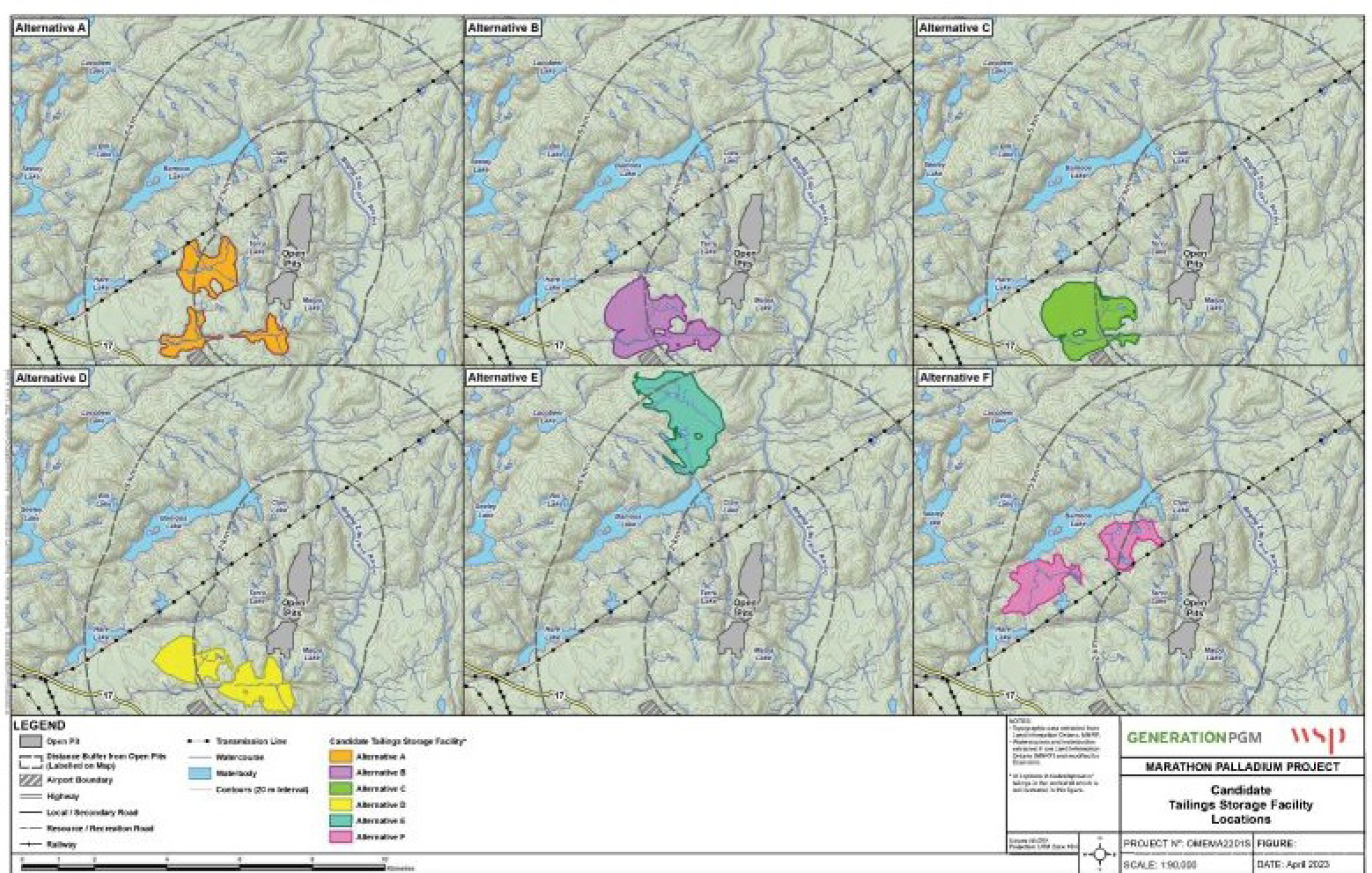
Figure 3: Tailings Storage Facility alternatives - Text version
The figure shows six smaller maps of the of the Marathon Palladium mine site with each individual map presenting a different configuration for the tailings storage facility in relation to the open pits and nearby topographical features such as relief contours, bodies of water, and highways and secondary roads. The image is structured to assist in evaluating the most suitable options for the tailings storage facility. The figure has two rows with three maps in each row, labelled Alternatives A through F.
Alternative A (upper left): This option consists of three separate irregular areas, each located south, southwest, and west of the open pits, respectively.
Alternative B (upper middle): This option consists of one irregular area located to the southwest of the open pits.
Alternative C (upper right): This option consists of one irregular area located to the southwest of the open pits, similar to Alternative B but with a slightly different configuration.
Alternative D (lower left): This option consists of two irregular areas, one located to the south and one to the southwest of the open pits.
Alternative E (lower middle): this option consists of one irregular area located to the northwest of the open pits.
Alternative F (lower right): this option consists of two irregular areas located to the west of the open pits.
A legend at the bottom of the figure describes the symbols used to indicate features on the map, including the footprint of the three open pits shaded in dark gray, and tailings storage facility options that are color-coded as follows: Alternative A is shaded in orange, Alternative B in purple, Alternative C in green, Alternative D in yellow, Alternative E in turquoise, and Alternative F in pink. Other map features indicated on the legend include distance buffers from the open pits, an airport boundary, highways, local/secondary roads, resource/recreation roads, railway, transmission lines, watercourses, water bodies, and contours (20-meter intervals)
| Option | Option description | Waterbody loss (ha) | Wetlands loss (ha) | Proponent cost table b1 note * (in millions of dollars) |
|---|---|---|---|---|
| A | Consists of 2 separate tailings storage areas and a WMP, which will have a total footprint of 321 ha. Cell 1, located west of the South Pit, will store NAG tailings. Cell 2, located south of Cell 1, will store PAG tailings and mine rock, and will be overlaid with NAG later in the mine life. The WMP will be constructed after six years and will store reclaim process water and manage site runoff. Excess water will be treated and discharged by pipeline to Hare Lake. | 9.08 | 8.2 | 287.3 |
| B | Consists of a multicell facility (two cells divided by a lined rockfill embankment) and a WMP, which will have a total footprint of 367 ha. Cell 1 will store PAG tailings and mine rock, and will be overlaid with NAG later in the mine life. Cell 2 will store NAG tailings. The WMP will store reclaim process water and manage runoff from the site. Excess water from the WMP and Cell 1 will be treated and discharged by pipeline into Hare Lake. | 3.93 | 12.3 | 529.2 |
| C (preferred option) | Consists of a multicell facility, a WMP and a SWMP and, which will have a total footprint of 356 ha. Cell 1 will contain NAG tailings. Cell 2 will contain PAG tailings and mine rock, and will be overlaid with NAG later in the mine life. The SWMP is located downstream/catchment area of the site footprint and will be used for construction phase water management, as well as to catch storm water runoff from the process plant and open pits during operations. The WMP will store reclaim process water from Cell 1 and water pumped from the SWMP. Excess water from the WMP and Cell 1 will be treated and discharged by pipeline to Hare Lake. | 3.66 | 13.8 | 473.7 |
Table b1 note(s)
|
||||
Assessment of options for the location of the Mine Rock Storage Area
The Proponent identified six options for the storage of mine rock, as shown in Figure 4. The options were developed based on the threshold criteria that the location of the MRSA be less than 5 km from the open pits. This criterion was chosen to reduce greenhouse gas emissions, decrease the risk of collisions with wildlife and decrease disturbed habitat.
During the pre-screening analysis phase, options 1 and 5 were dismissed for not meeting one, or both of the following criteria:
- The option avoids overprinting other mine infrastructure, including the preferred TSF option.
- The option does not overprint areas with known potential ore resources that could result in loss of a future economic opportunity.
The Proponent developed a multiple accounts analysis to further characterize the four remaining options (see Table 2). The multiple accounts analysis found that alternative 4 performed the best for the environmental, economic, and socio-economic sub-accounts.
Figure 4: Mine Rock Storage Area alternatives
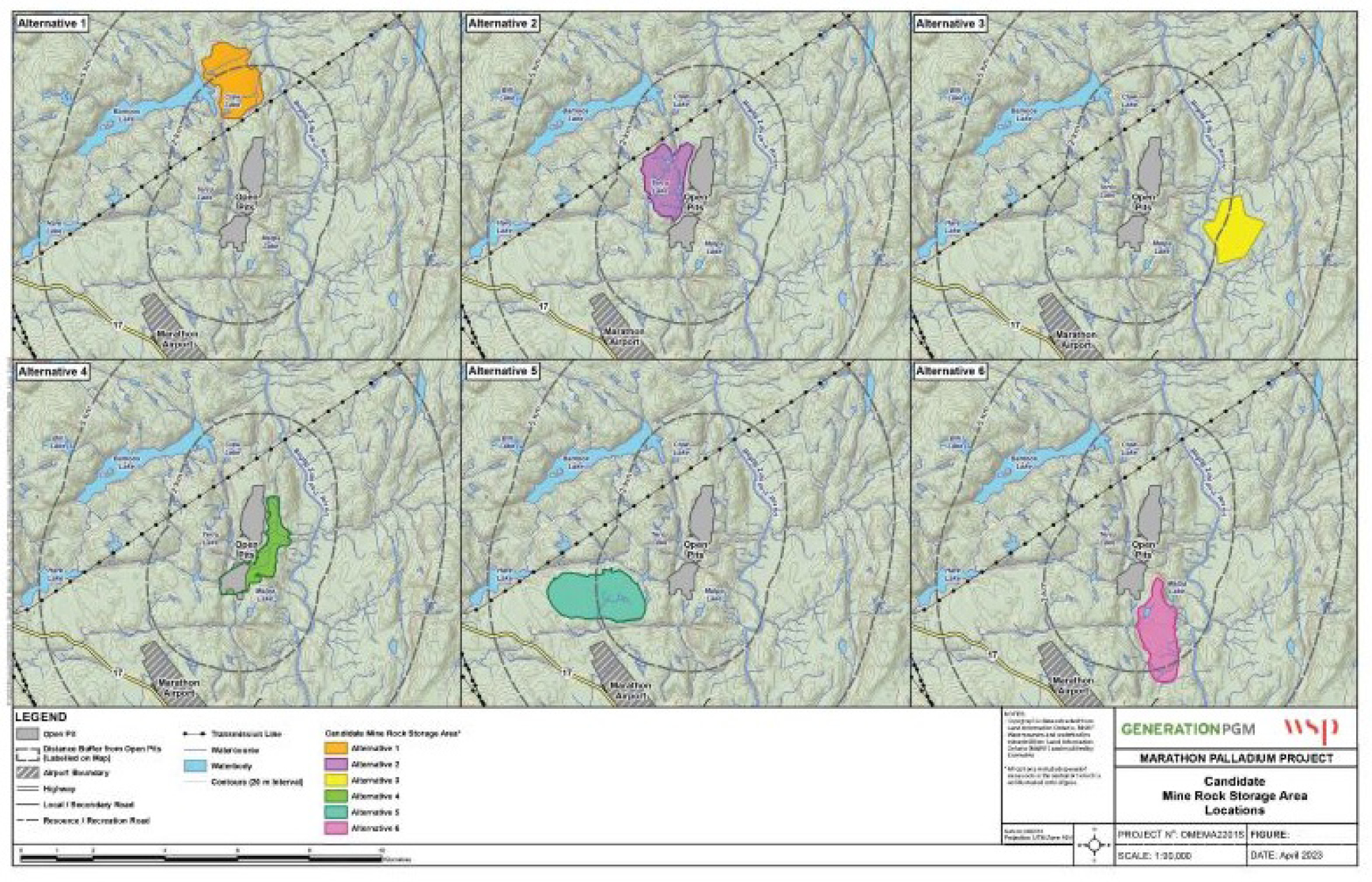
Figure 4: Mine Rock Storage Area alternatives - Text version
The figure shows six smaller maps of the of the Marathon Palladium mine site with each individual map presenting a different configuration for the mine rock storage area in relation to the open pits and nearby topographical features such as relief contours, bodies of water, and highways and secondary roads. The image is structured to assist in evaluating the most suitable option for the mine rock storage area. The figure has two rows with three maps in each row, labelled Alternatives 1 through 6.
Alternative 1 (upper left): This option consists of one irregular area located north of the open pits.
Alternative 2 (upper middle): This option consists of one irregular area located immediately to the west of the open pits.
Alternative 3 (upper right): This option consists of one irregular area located to the east of the open pits.
Alternative 4 (lower left): This option consists of one irregular area, located immediately to the east of the open pits.
Alternative 5 (lower middle): this option consists of one irregular area located to the southwest of the open pits.
Alternative 6 (lower right): this option consists of two irregular areas located to the southeast of the open pits.
A legend at the bottom of the figure describes the symbols used to indicate features on the map, including the footprint of the three open pits shaded in dark gray, and mine rock storage area options that are color-coded as follows: Alternative 1 is shaded in orange, Alternative 2 in purple, Alternative 3 in yellow, Alternative 4 in green, Alternative 5 in turquoise, and Alternative 6 in pink. Other map features indicated on the legend include distance buffers from the open pits, an airport boundary, highways, local/secondary roads, resource/recreation roads, railway, transmission lines, watercourses, water bodies, and contours (20-meter intervals).
| Option | Option description | Water body loss (ha) | Wetlands loss (ha) | Proponent cost table b2 note * (in millions of dollars) |
|---|---|---|---|---|
| 2 | Option 2 has a capacity of 330 Mt and an approximate footprint of 209 ha. Five sumps/catch basins, perimeter ditching and pumping will be used to transfer contact water to the WMP. | 9.75 | 2.79 | 44.0 |
| 3 | Option 3 has a capacity of 330 Mt and an approximate footprint of 193 ha. This option is located outside the Project property boundary and does not overprint water that may be frequented by fish. Five sumps/catch basins, perimeter ditching and pumping will be used to transfer contact water across the Biigtig Zibi to the WMP. | 0 | 0 | 51.4 |
| 4 (preferred option) | Option 4 has a capacity of 330 Mt and an approximate footprint of 180 ha. Two sumps/catch basins, perimeter ditching and pumping will be used to transfer contact water to the WMP. | 0.77 | 1.03 | 36.6 |
| 6 | Option 6 has a capacity of 330 Mt and an approximate footprint of 222 ha. Nine catch basins, perimeter ditching and pumping will be used to transfer contact water to the WMP. | 3.25 | 0 | 61.1 |
Table b2 note(s)
|
||||
Regulatory analysis
Benefits and costs
Analytical framework
The analysis below examines the incremental impacts of the amendments on the environment, Indigenous peoples, businesses (the Proponent) and the Government. While costs to the Proponent are known and monetized, it is not feasible to quantify and monetize benefits due to data limitations. As a result, the cost-benefit analysis reflects monetized costs and qualitatively described environmental impacts.
DFO determined that the FHCP proposed by the Proponent is appropriate and meets the principles of DFO’s Policy for applying measures to offset adverse effects on fish and fish habitat under the Fisheries Act. These principles include, but are not limited to, restoring degraded fish habitat to improve conditions for the production of fish, enhancing fish habitat to improve conditions for the production of fish and creating productive and sustainable fish habitat where none existed before. The cost and environmental impacts of the amendments could change if the FHCP is subsequently amended to further accommodate Indigenous interests.
Environmental impacts
The disposal of mine waste will destroy 10 water bodies that are frequented by fish, totalling 3.66 ha of fish habitat. The impacted water bodies are a portion of Angler Creek and two tributaries, portions of two unnamed streams and tributaries to the Pic River, an upstream portion of a tributary to Angler Creek, and a portion of a tributary to the Pic River. Table 3 lists the affected fish species in those water bodies.
| Water bodies impacted | Fish species affected or *inferred |
|---|---|
| A portion of Angler Creek, and two Angler Creek tributaries | Brook stickleback, coho salmon, longnose dace, mottled sculpin, rainbow trout |
| Portions of two unnamed streams and tributaries to the Pic River | *Brook trout, *johnny darter, *longnose dace, *mottled sculpin, *rainbow trout, *slimy sculpin |
| Upstream portion of a tributary to Angler Creek | Brook stickleback |
| A portion of a tributary to the Pic River | *Brook trout, *finescale dace, *northern pearl dace, *northern redbelly dace |
To compensate for the loss of fish habitat, the Proponent developed an FHCP. The plan outlines targeted measures to support regional fisheries management objectives and increase recreational fishing and traditional harvest opportunities within the area.
Figure 5: Location of compensation measures under the FHCP
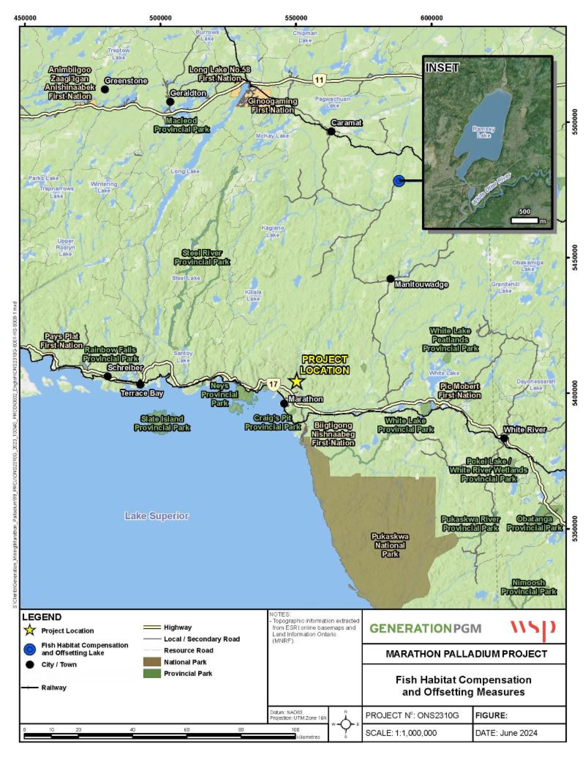
Figure 5: Location of compensation measures under the FHCP - Text version
The map shows the location of the fish habitat compensation measures for the Marathon Palladium project in relation to the mine site. The Marathon Palladium Project mine is highlighted at the centre of the map with a yellow star. The location of the fish habitat compensation measures is indicated with a blue dot near the top right of the map. An inset top right corner of the figure shows an enlarged map of Ramsay Lake.
The legend at the bottom of the map describes the symbols used to indicate features on the map, including the project location, the location of the fish habitat compensation lake, cities/towns, railways, highways, local/secondary roads, resource roads, national parks, and provincial parks.
The loss of fish habitat will be offset by the implementation of the FHCP, as required under section 27.1 of the MDMER. Approval of the FHCP must be obtained before the Proponent begins depositing deleterious substances into the TIAs. The implementation of the compensatory measures will result in the creation of 11.74 ha of fish habitat of equivalent quality compared to the fish habitat to be destroyed by the disposal of mine waste.
Ramsay Lake is located approximately 83 km northwest of the Marathon Project, within the traditional territory of Ginoogaming First Nation and near the traditional territories of Biigtigong Nishnaabeg First Nation and Pays Plat First Nation. The lake is fed from the north by Stillwell Creek. Fish passage into Ramsay Lake from Stillwell Creek is impeded by beaver dams, rapids, and two human-made flumes for legacy wood passage activities. Fish passage is further impeded by a spillway dam at the outlet of Ramsay Lake. Fish survey data show that Ramsay Lake is capable of supporting Walleye, but that a lack of spawning habitat limits their reproduction. To enhance Walleye spawning habitat in Ramsay Lake, the FHCP includes the following elements:
- Spawning shoals: six spawning shoals will be constructed along the east shoreline of Ramsay Lake (as shown in Figure 5). The shoals will be constructed of a suitable boulder/cobble spawning substrate, which will improve spawning habitat availability and overall Walleye production. The spawning habitat is expected to benefit species other than Walleye, including White Sucker, Lake Whitefish, other forage fish and crayfish.
- Tree piles: twelve tree piles will be constructed, with two placed on each of the shoals. The tree piles will provide shelter and forage habitat for early life stage Walleye.
Placement of this additional spawning habitat is expected to increase recruitment within Ramsey Lake, not only for Walleye, but for other species, including White Sucker, Lake Whitefish and forage fish that utilize rocky substrate for spawning. These features would also increase habitat of crayfish, which is an important part of the food chain in the lake.
Improvements to the spillway dam to aid fish passage may be carried out in the future. A contingency to account for changes to the spawning shoals as a result of this work has been built into the financial guarantee.
Cost to business
The implementation of the FHCP associated with the amendments to compensate for the destruction of 3.66 ha of fish habitat is estimated to cost $1.9 million.footnote 7 The Proponent must submit an irrevocable letter of credit, or equivalent financial guarantee, covering implementation costs of the plan. Table 4 describes the estimated costs associated with the implementation of the FHCP.
| Description | Undiscounted amount in 2024 Canadian dollars | Amount discounted at a rate table b4 note a of 3% | Proposed schedule |
|---|---|---|---|
| Construction | $1,753,479 | $1,751,593 | (2024–2025) |
| Monitoring | $164,480 | $143,750 | (2024–2033) |
| Total | $1,917,959 | $1,895,343 | (2024–2033) |
Table b4 note(s)
|
|||
Cost to government
Government of Canada enforcement activities include inspections to monitor the implementation of the FHCP, which may have associated incremental costs. Specifically, there may be costs incurred associated with site visits, monitoring and review of the FHCP to ensure compliance with the Fisheries Act and the MDMER. These incremental costs will be low, given that monitoring activities and associated costs will occur intermittently during the implementation of the FHCP. Therefore, the total incremental costs to the Government of Canada associated with the proposed FHCP will be low.
Table 5: Cost-benefit statement
| Impact | Stakeholder | Total (present value) | Annualized average discounted at a rate of 3% (10 years) |
|---|---|---|---|
| Costs | Generation PGM Inc. | 1.90 | 0.22 |
| Impact | Stakeholder | Description |
|---|---|---|
| Positive impacts | Indigenous peoples, general public | The loss of fish habitat associated with the disposal of tailings and waste rock will be offset by the implementation of a compensation plan that will create 11.74 ha of fish habitat. This will result in a net 8.08 ha increase in fish habitat. |
| Negative impacts | Indigenous peoples, general public | The loss of fish habitat associated with the disposal of tailings and waste rock amounts to 3.66 ha. |
Small business lens
There are no impacts on small business associated with the amendments. Generation PGM Inc., the owner and operator of the mine, does not meet the definition of small business as set out in the Policy on Limiting Regulatory Burden on Business.
One-for-one rule
The one-for-one rule does not apply, as there is no incremental change in administrative burden on businesses.
Regulatory cooperation and alignment
The proposal is not related to a work plan or commitment under a formal regulatory cooperation forum and, therefore, does not need to align or cooperate with external regulatory frameworks.
Strategic environmental assessment
A strategic environmental assessment concluded that authorizing the disposal of tailings in a TIA will have adverse environmental effects, namely the loss of fish habitat. However, the adverse environmental effects will be offset by the implementation of an FHCP that will result in no net loss of fish habitat.
Gender-based analysis plus
A gender-based analysis plus (GBA+) indicated that there may be disproportionate impacts on Indigenous Peoples, given the geographic location of the Project. However, environmental impacts will be avoided, mitigated and, when required, offset through provincial and federal processes, including the implementation of the FHCP to offset any residual impacts on fish habitat resulting from the disposal of mine waste.
Implementation, compliance and enforcement, and service standards
The amendments come into force on the day on which they are registered. The amendments will designate the use of certain water bodies that are frequented by fish for disposal of tailings and mine rock generated from the activities of the Marathon Palladium Project. Before the Proponent can begin work, all the conditions under section 27.1 of the MDMER need to be met for the Minister of the Environment to approve the FHCP.
Given that the MDMER are made pursuant to the Fisheries Act, enforcement personnel would, when verifying compliance with the MDMER, act in accordance with the Compliance and enforcement policy for habitat and pollution provisions of the Fisheries Act. Verification of compliance with the MDMER and the Fisheries Act will include, among other inspection activities, site visits, sample analysis, review of FHCPs and related reports associated with the proposed amendments. An enforcement officer may conduct an investigation when there are reasonable grounds to believe that an offence is being or has been committed.
As set out in the Policy, if there were evidence of an alleged offence, enforcement officers would determine an appropriate enforcement action, in accordance with the following criteria:
- The nature of the alleged violation: Factors to be considered include the seriousness of the damage or potential damage to fish habitat, the fishery resource, or the risks associated with the human use of fish, the intent of the alleged violator, whether it is a repeated occurrence, and whether there were attempts to conceal information or otherwise circumvent the objectives and requirements of the Act and its regulations.
- Effectiveness in achieving the desired result with the alleged violator: The desired result is compliance with the Act in the shortest possible time and with no further occurrence of violations, and factors to be considered include the history of compliance with the Fisheries Act, willingness to cooperate with enforcement personnel, evidence and extent of corrective action already taken, and the existence of enforcement actions by other federal or provincial/territorial authorities.
- Consistency in enforcement: Enforcement officers will consider how similar situations are being or have been handled in determining the measure to take.
The Policy sets out the range of possible responses to alleged violations, including issuance of warnings, directions, authorizations and Ministerial orders, and/or court actions, such as injunctions, prosecution, court orders upon conviction and civil suits for recovery of costs.
Contacts
Nicole Folliet
Executive Director
Mining and Processing Division
Industrial Sectors and Chemicals Directorate
Environment and Climate Change Canada
351 Saint-Joseph Boulevard
Gatineau, Quebec
K1A 0H3
Email: ec.mmer-remm.ec@canada.ca
Matthew Watkinson
Executive Director
Regulatory Analysis and Valuation Division
Economic Analysis Directorate
Environment and Climate Change Canada
351 Saint-Joseph Boulevard
Gatineau, Quebec
K1A 0H3
Email: ec.darv-ravd.ec@canada.ca