
Regulations Amending the Metal and Diamond Mining Effluent Regulations: SOR/2023-122
Canada Gazette, Part II, Volume 157, Number 13
Registration
SOR/2023-122 June 9, 2023
FISHERIES ACT
P.C. 2023-552 June 9, 2023
Her Excellency the Governor General in Council, on the recommendation of the Minister of the Environment, makes the annexed Regulations Amending the Metal and Diamond Mining Effluent Regulations under subsection 36(5) of the Fisheries Act footnote a.
Regulations Amending the Metal and Diamond Mining Effluent Regulations
Amendment
| Item | Column 1 Water or Place |
Column 2 Description |
|---|---|---|
| 69 | All waters located within the area described in column 2, located approximately 112 km southwest of Vanderhoof, British Columbia | The waters located within an area located approximately 112 km southwest of Vanderhoof, British Columbia. More precisely, the area bounded by four straight lines connecting four points starting at the point located at 53°11′10.048″ north latitude and 124°52′40.603″ west longitude to the point located 1344 m southeast at 53°10′27.330″ north latitude and 124°52′27.145″ west longitude to the point located 1548 m southwest at 53°09′42.169″ north latitude and 124°53′03.144″ west longitude to the point located 2330 m northwest at 53°10′50.110″ north latitude and 124°53′57.514″ west longitude to the point located 1555 m northeast at 53°11′10.048″ north latitude and 124°52′40.603″ west longitude. |
| 70 | All waters located within the area described in column 2, located approximately 112 km southwest of Vanderhoof, British Columbia | The waters located within an area located approximately 112 km southwest of Vanderhoof, British Columbia. More precisely, the area bounded by seven straight lines connecting seven points starting at the point located at 53°12′48.783″ north latitude and 124°51′39.703″ west longitude to the point located 1454 m southeast at 53°12′14.326″ north latitude and 124°50′46.321″ west longitude to the point located 1183 m southwest at 53°11′36.558″ north latitude and 124°50′56.658″ west longitude to the point located 1291 m northwest at 53°11′49.763″ north latitude and 124°52′02.643″ west longitude to the point located 3532 m southwest at 53°11′18.766″ north latitude and 124°55′05.803″ west longitude to the point located 445 m northwest at 53°11′27.921″ north latitude and 124°55′24.316″ west longitude to the point located 3097 m northeast at 53°12′32.992″ north latitude and 124°53′17.433″ west longitude to the point located 1878 m northeast at 53°12′48.783″ north latitude and 124°51′39.703″ west longitude. |
| 71 | All waters located within the area described in column 2, located approximately 112 km southwest of Vanderhoof, British Columbia | The waters located within an area located approximately 112 km southwest of Vanderhoof, British Columbia. More precisely, the area bounded by nine straight lines connecting nine points starting at the point located at 53°13′37.192″ north latitude and 124°51′41.053″ west longitude to the point located 876 m southeast at 53°13′11.869″ north latitude and 124°51′19.811″ west longitude to the point located 179 m southeast at 53°13′06.625″ north latitude and 124°51′15.738″ west longitude to the point located 213 m southeast at 53°13′00.422″ north latitude and 124°51′10.687″ west longitude to the point located 1161 m southeast at 53°12′29.352″ north latitude and 124°50′35.542″ west longitude to the point located 204 m southwest at 53°12′24.850″ north latitude and 124°50′43.608″ west longitude to the point located 1272 m northwest at 53°12′55.148″ north latitude and 124°51′30.005″ west longitude to the point located 2136 m northwest at 53°13′01.658″ north latitude and 124°53′24.651″ west longitude to the point located 1169 m northwest at 53°13′36.291″ north latitude and 124°53′50.010″ west longitude to the point located 2392 m northeast at 53°13′37.192″ north latitude and 124°51′41.053″ west longitude. |
| 72 | All waters located within the area described in column 2, located approximately 112 km southwest of Vanderhoof, British Colombia | The waters located within an area located approximately 112 km southwest of Vanderhoof, British Columbia. More precisely, the area bounded by four straight lines connecting four points starting at the point located at 53°13′21.584″ north latitude and 124°50′03.866″ west longitude to the point located 111 m southeast at 53°13′18.235″ north latitude and 124°50′01.694″ west longitude to the point located 428 m southwest at 53°13′13.331″ north latitude and 124°50′23.252″ west longitude to the point located 83 m northwest at 53°13′15.500″ north latitude and 124°50′25.850″ west longitude to the point located 449 m northeast at 53°13′21.584″ north latitude and 124°50′03.866″ west longitude. |
Coming into Force
2 These Regulations come into force on the day on which they are registered.
REGULATORY IMPACT ANALYSIS STATEMENT
(This statement is not part of the Regulations.)
Executive summary
Issues: BW Gold Ltd. (the Proponent), a wholly owned subsidiary of Artemis Gold Inc., is proposing to develop an open-pit gold and silver mine located approximately 112 kilometres (km) southwest of Vanderhoof, British Columbia. The Proponent will construct a tailings storage facility (TSF), low-grade ore (LGO) stockpiles, as well as non-acid generating (NAG) waste rock and overburden stockpiles to manage the mine waste generated by the mining operations. The building of these infrastructures will destroy 24 water bodies frequented by fish, by overlapping them. The Fisheries Act prohibits the deposit of deleterious substances into waters frequented by fish unless authorized by regulation. The Metal and Diamond Mining Effluent Regulations (MDMER) include provisions to allow for the disposal of mine waste in waters frequented by fish, under certain conditions.
Description: The Regulations Amending the Metal and Diamond Mining Effluent Regulations (the Amendments) will list four specific geographic areas (see Figure 3) on Schedule 2 of the MDMER, designating them as tailings impoundment areas (TIAs) and authorizing their destruction for the purpose of depositing deleterious substances (i.e. mine waste, mining ore). The four geographic areas encompass 24 water bodies and will represent a loss of 57.1 hectares (ha) of fish habitat.
Rationale: The Proponent assessed several options to determine the preferred disposal method and site location to manage mine waste,footnote 2 taking into account environmental, technical, economic and socio-economic factors. The Proponent prepared an Assessment of Alternatives (AA) report in accordance with the Department of the Environment’s Guidelines for the assessment of alternatives for mine waste disposal.
The preferred options for the TSF, the LGO stockpiles and NAG waste rock piles were selected on the basis of minimizing environmental impacts, including habitat destruction and watercourse crossings, and safeguarding the interests of Indigenous peoples and local communities with respect to the current use of lands and resources for traditional purposes. Between June 2021 and March 2023, the Department of the Environment consulted First Nations that may be adversely impacted by the Blackwater Project (the Project) and consulted the public on the Amendments. Lhoosk’uz Dené Nation and Ulkatcho First Nation provided letters of support and, along with the Carrier Sekani First Nations, will continue to engage with the Proponent on Nation-specific interests to offset the loss of fish habitat.
The MDMER require that the Proponent develop and implement a fish habitat compensation plan (FHCP) to offset the loss of fish habitat resulting from the disposal of mine waste in waters frequented by fish. A letter of credit or equivalent financial guarantee is required from the Proponent to cover the cost of implementation of the FHCP, which is estimated at 13.7 million dollarsfootnote 3 over a 14-year period (2023 to 2036). The implementation of the FHCPfootnote 4 will result in the creation of 110.7 ha of fish habitat, which is significantly more habitat than the loss associated with the destruction of the 24 waterbodies to be listed on Schedule 2 of the MDMER.
Issues
The Proponent, BW Gold Ltd. (formerly New Gold Inc.), proposes the development of an open-pit gold and silver mine located approximately 112 km southwest of Vanderhoof, British Columbia. The disposal of mine waste will destroy 24 water bodies frequented by fish for a total of 57.1 ha of fish habitat. Subsection 36(3) of the Fisheries Act (the Act) prohibits the deposit of deleterious substances into waters frequented by fish unless authorized by regulation. The MDMER include provisions to allow for the disposal of mine waste in waters frequented by fish, under certain conditions. For the Proponent to be able to dispose of mine waste into waters frequented by fish, the water bodies must first be listed to Schedule 2 of the MDMER.
Background
Metal and Diamond Mining Effluent Regulations
The MDMER, which came into force on June 1, 2018,footnote 5 prescribe the maximum authorized limits for deleterious substances in mine effluent in Schedule 4 (e.g. arsenic, copper, cyanide, lead, nickel, zinc, radium 226, un-ionized ammonia and suspended solids). The MDMER also specify the allowable acidity or alkalinity (pH range) of mine effluent and require that mine effluent not be acutely lethal.footnote 6 The MDMER further require that mine owners and operators sample and monitor effluents to ensure compliance with the authorized limits and to determine any impact on fish, fish habitat and fishery resources. The Department of the Environment publishes annual performance summaries for mines with respect to selected standards prescribed by the MDMER.
The use of waters frequented by fish for mine waste disposal can only be authorized through an amendment to the MDMER by listing the water body in its Schedule 2, designating it as a TIA.footnote 7 As of May 2023, 68 water bodies or geographic areas are listed in Schedule 2 of the MDMER. Section 27.1 of the MDMER requires the development and implementation of an FHCP to offset the loss of fish habitat that would occur as a result of the use of a fish-frequented water body for mine waste deposit. The FHCP must be approved by the Minister of the Environment before any mine waste is deposited into the relevant water bodies. The owner or operator of a mine is also required to submit an irrevocable letter of credit or an equivalent financial guarantee, to ensure that funds are in place, should the owner or operator fail to address all the elements of the FHCP.
For any project where the proposed mine waste disposal would affect fish-frequented waters, proponents must consider alternatives for mine waste disposal and demonstrate that the preferred option is the best option based on environmental, technical, economic and socio-economic criteria specified in the Department of the Environment’s Guidelines for the assessment of alternatives for mine waste disposal. As part of these guidelines, proponents must also undertake preliminary consultations on how alternative mine waste disposal options were assessed and how the preferred option was determined.
Blackwater Project
The Proponent is proposing to develop an open-pit gold and silver mine located 112 km southwest of Vanderhoof, and 446 km northeast of Vancouver, British Columbia (See Figure 1). The Project mine site and access road are located within the traditional territories of Lhoosk’uz Dené Nation, Ulkatcho First Nation, Skin Tyee Nation and Tsilhqot’in Nation and other Project components cross the traditional territories of the Nazko First Nation, Nadleh Whut’en First Nation, Saik’uz First Nation, and Stellat’en First Nation. The mine site will cover an area of approximately 4 400 hectares and will comprise an open pit, ore processing facilities, a TSF, waste rock dumps and stockpiles, freshwater supply system, camps, a transmission line and access roads.
The construction phase of the Project is expected to last two years, followed by a 23-year operational phase. Reclamation and closure activities would occur between year 24 and year 47. Production will be ramped up in three phases:
- Years 1 to 5: 15 000 tonnes/day or 5.5 million tonnes per annum
- Years 6 to 10: 33 000 tonnes/day or 12 million tonnes per annum
- Years 11 to 23: 55 000 tonnes/day or 20 million tonnes per annum
Figure 1: Location of the Blackwater Project
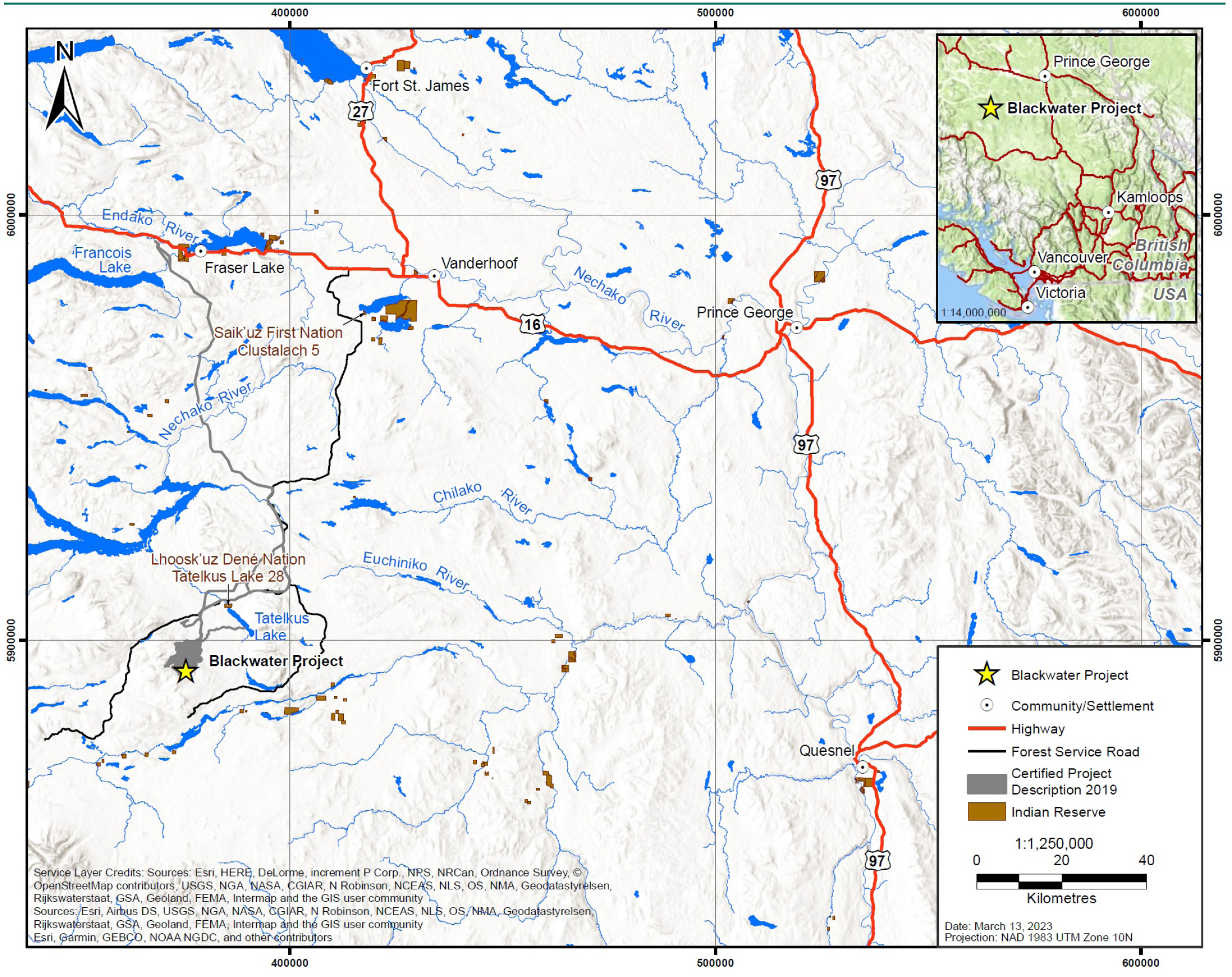
Figure 1: Location of the Blackwater Project - Text version
The top-right corner of the figure shows a smaller map of the province of British Columbia at a scale of 1:14,000,000. A star pinpointing the location of the project in relation to the cities of Prince George to the north-east at the top of the map and Vancouver directly south at the bottom of the map. The enlarged area at a 1:1,250,000 scale map shows the general location of the Blackwater Gold Project in British Columbia at the bottom-left corner of the map. It shows the location of the project with respect to larger cities: Fraser Lake to the north of the project location, Prince George to the north-east of the project location, and Quesnel to the east of the project location. The figure also highlights three major highways. Starting from the top-left corner, Highway 16 moving west to east and connecting Fraser Lake, Vanderhoof and Prince George; at the top of the map, Highway 27 moving north to south through Fort St-James and connecting to Highway 16; and to the top-right of the map, Highway 97 moving north to south, connecting to Highway 16 and moving through Prince George to Quesnel at the bottom-right of the map.
Mine infrastructure to affect fish-frequented water bodies
The construction and development of a TSF, LGO stockpiles, as well as NAG overburden and waste rock storage facilities will result in the loss of 24 streams for a total of 57.1 ha of fish habitat over four specific geographic areas (See Figure 2 and Figure 3). Twenty-two of these streams are located in the Davidson Creek watershed and two streams are located within the Creek 661 watershed.
Rainbow trout is the most ubiquitous species present in almost every water body in the local area of the Project. Longnose sucker is the second most common species, followed by mountain whitefish and kokanee. None of the fish species in the Project area are identified as at-risk by the Committee on the Status of Endangered Wildlife in Canada. Rainbow trout predominantly use the water bodies as juvenile rearing habitat in the summer and, to a lesser extent, as springtime spawning and over-wintering habitat.
In accordance with the Decision Statement (PDF), a fish salvage and relocation plan, which was developed in consultation with Indigenous peoples, will be implemented prior to the construction of the TSF, LGO stockpiles and the NAG overburden and waste rock storage facilities. The overall objective of this plan is to avoid killing fish during the construction phase of the Project. To meet this objective, the plan will employ best practices and methods for fish capture, handling, and relocation that minimize stress on fish and support survival of fish; ensure accurate data collection throughout the fish salvage program; and ensure there are no negative impacts to fish already living in water bodies into which salvaged fish will be released.
Tailings storage facility
The TSF is intended to have minimal long-term impact on the environment, provide long-term, reliable, and permanent containment with minimal maintenance and monitoring requirements and be capable of safely and effectively containing tailings and potentially acid-forming and metal-leaching waste rock generated over the life of the mine. The TSF is designed to permanently store 334 million tonnes of tailings, as a thickened-slurry, and 467 million tonnes of waste rock. The TSF will consist of two adjacent sites, TSF C and TSF D, comprising a total of four dams: the Main Dam D, the Main Dam C, the Saddle Dam and the West Dam.
TSF C will initially be constructed and designed to accommodate up to approximately 17 years of tailings and the first 6 years of waste rock. Beginning in Year 5 of the Project, the Proponent will construct Main Dam D, parallel to and downstream of TSF C to provide additional storage capacity for waste rock and tailings. In Year 7, 2 years after construction, filling of the TSF will begin.
An environmental control pond will be the primary seepage collection point downstream of the TSF after construction of TSF D, which will be located approximately 1 km downstream on Davidson Creek. It will be fed by two interceptor ditches that will convey runoff to TSF D and maintain a minimum water level. The TSF and the environmental control pond will result in the loss of 46.3 ha of fish habitat.
Two ore stockpiles
Higher-grade ore mined from the open-pit will be directly delivered to the crusher, while lower-grade ore will be conveyed to two stockpiles. Over the life of the mine, the ore stockpiles will be re-handled back to the crusher. The Proponent estimates that up to 111 million tonnes of ore, mostly low-grade, will be stockpiled. The ore stockpiles will result in the loss of 9.2 ha of fish habitat.
Overburden and non-acid generating waste rock storage facilities
Excess non-acid producing waste material from open pit mining will be stockpiled in waste rock storage facilities. Overburden and NAG waste not used in the construction of the TSF will be stored in either the upper or lower overburden stockpiles. Only the upper overburden stockpile, which will be located directly west of the pit limits, will affect fish habitat. Having two distinct stockpiles provides the Proponent with more flexibility for ramping up the mine production by splitting ore between a low-grade stockpile and a high-grade stockpile. These facilities will result in the loss of 1.6 ha of fish habitat.
Environmental assessment of the Blackwater Project
The Project was subject to both a provincial class environmental assessment (EA) under the Environmental Assessment Act (PDF) [SBC 2002] and a federal EA under the former Canadian Environmental Assessment Act, 2012 (CEAA 2012).
On April 15, 2019, the Minister of the Environment issued an EA Decision Statement (PDF) indicating that the Project is not likely to cause significant adverse environmental effects referred to in subsections 5(1) and (2) of the former CEAA, 2012. The former Canadian Environmental Assessment Agency — currently the Impact Assessment Agency of Canada (IAAC) — identified key mitigation measures and follow-up program requirements for consideration by the Minister of the Environment in establishing conditions as part of the Decision Statement, in the event that the Project is permitted to proceed.
On May 17, 2019, the Assessment Report issued by the Provincial Environmental Assessment Office concluded that the EA process adequately identified and assessed potential adverse environmental, economic, social, heritage and health effects of the proposed Project.
Subsequently, the Proponent made changes to the Project to optimize the mine site, and in July 2022, informed the IAAC of the changes. The main changes related to the assessment of alternatives for mine waste disposal included the following:
- extending the life of the mine from 17 to 23 years;
- the ore processing rates changing from 66 000 tonnes per day, to an incremental increase over three phases going from 15 000 tonnes per day, to 33 000 tonnes per day, to 55 000 tonnes per day;
- the TSF C main dam will be located farther downstream from the original location approved in the 2019 EA certificate;
- the split of the LGO stockpile into two co-located piles where its maximum capacity increased from 60 Mt to 111 Mt and its maximum storage was extended from Year 10 to Year 15 of the Project;
- the addition of a second overburden and waste rock pile located immediately south of the TSF C.
In October 2022, the IAAC informed the impacted Indigenous peoples of the optimization changes and requested their comments. IAAC did not receive significant comments from the impacted Indigenous peoples. On December 8, 2022, the IAAC issued a statement concluding that their assessment of the changes to the Project does not affect the conclusion and conditions in the Decision Statement. The IAAC is also of the view that the rights of Indigenous peoples would not be further impacted by the changes to the Project.
Objective
The objective of the Amendments is to authorize the deposit of mine waste generated by the Blackwater Project to certain fish-frequented water bodies. A requirement to this authorization is for the Proponent to offset the loss of fish habitat resulting from the disposal of mine waste by developing and implementing an FHCP.
Description
The Amendments will list four specific geographic areas in Schedule 2 of the MDMER (see Figures 2 and 3), designating them as TIAs and authorizing their use for the disposal of mine waste. The four geographic areas will encompass 24 water bodies and will represent a loss of 57.1 ha of fish habitat.
Figure 2: Location of water bodies to be listed in Schedule 2 of the MDMER
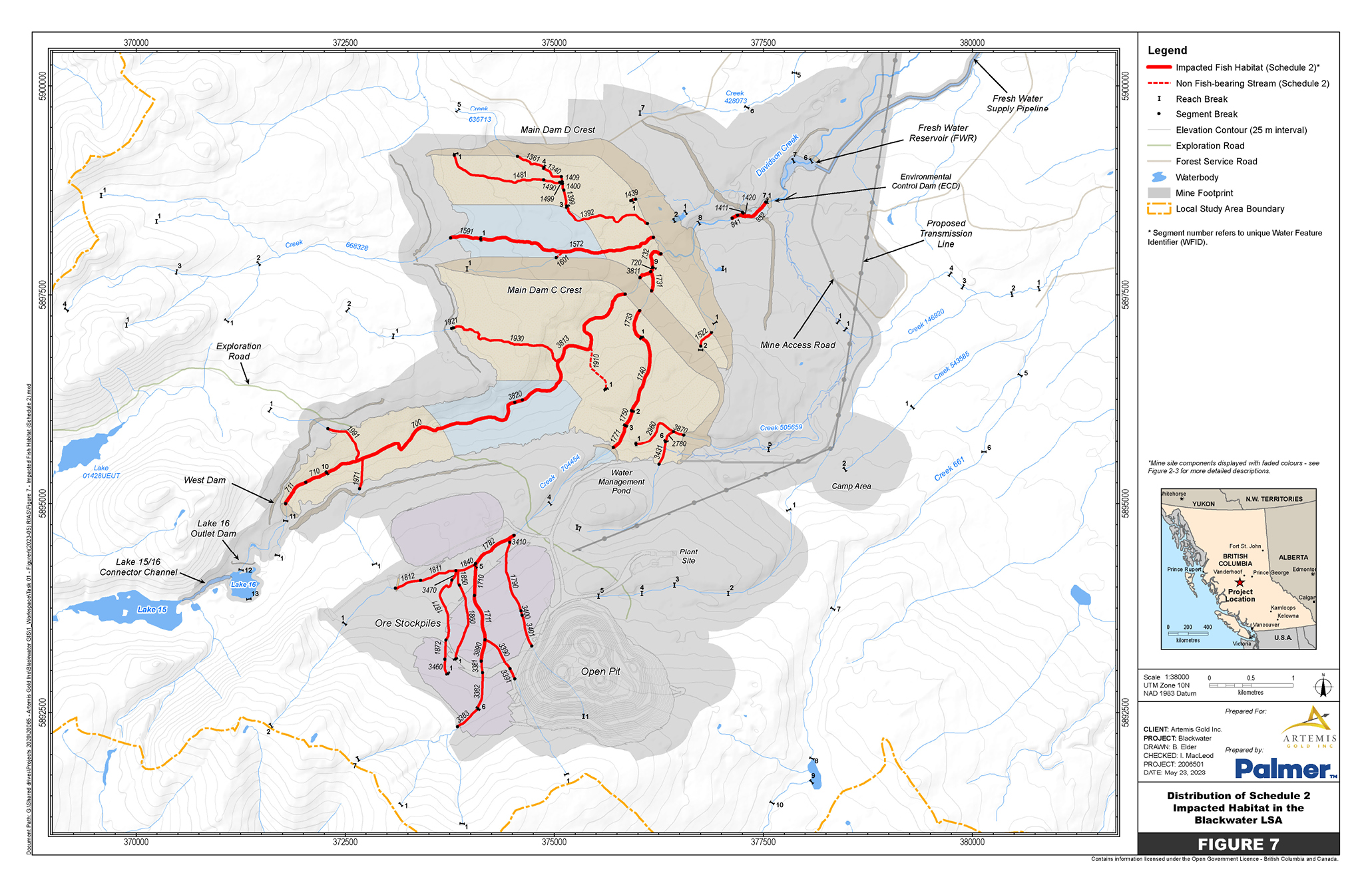
Figure 2: Location of water bodies to be listed in Schedule 2 of the MDMER - Text version
The location of the Blackwater gold mine site in grey. The map highlights the impacted water bodies in red with numerical identifiers on each segmented portion of the water bodies. The top-right of the map shows a fresh water supply pipeline that moves south-west to a fresh water reservoir connecting to Davidson Creek. Immediately south-west is the Environmental Control Dam, where two sections of water bodies are impacted. Continuing south-west to the centre of the map is the Tailings Storage Facility (TSF) with a Main Dam D Crest on the north end, where eight sections of water bodies are impacted; and a Main Dam C Crest at the centre, where eight sections of water bodies are impacted. The longest water body in the TSF moves south-west to the left of the map. The bottom-centre of the map shows the location of the ore stockpiles, where six sections of water bodies are impacted. Immediately to the east of the ore stockpiles is the main pit and to the north is the TSF.
Figure 3: Specific geographic areas to be listed in Schedule 2 of the MDMER
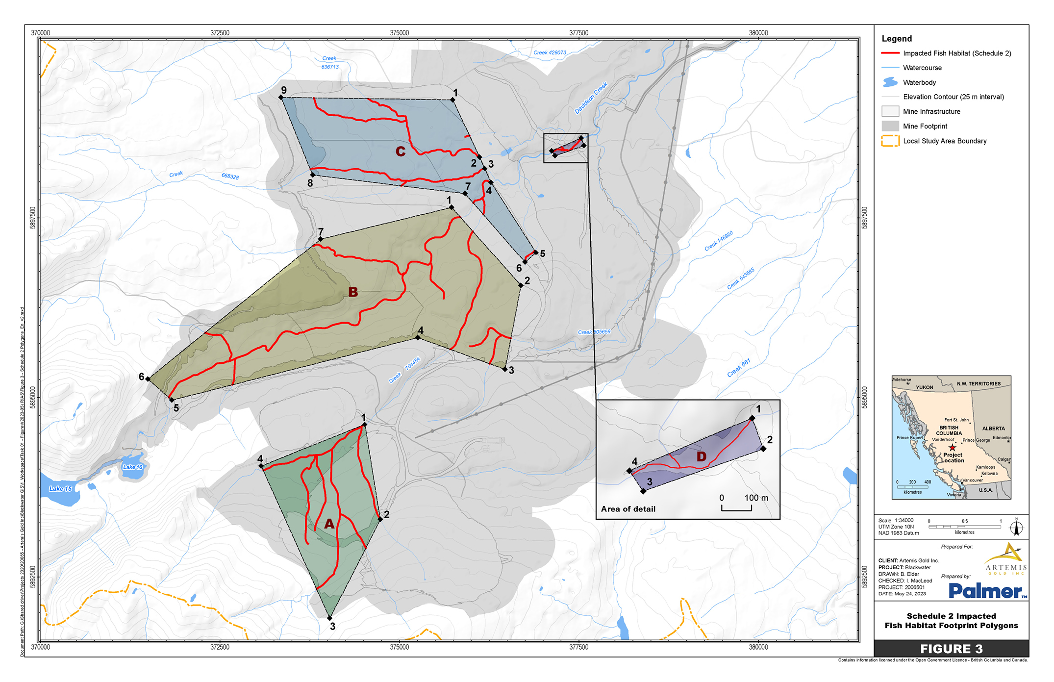
Figure 3: Specific geographic areas to be listed in Schedule 2 of the MDMER - Text version
Geographic Area C is at the top-centre of the map and is located over the section of the Tailings Storage Facility with the Main Dam D Crest. Geographic Area C contains eight impacted water bodies and the specific points of the irregular polygon, of which there are nine. Starting at point 1 at the top-centre and moving clockwise, the lines of the polygon move southeast through points 2 to 5, southwest to point 6, northwest to point 7, west to point 8, north to point 9 and, finally, east to point 1.
Geographic Area D at the top-right of the map and is located on the Environmental Control Dam. Geographic Area D is enlarged to the bottom-right of the map to show the two impacted water bodies and the specific points of the rectangular polygon, of which there are four. Starting at point 1 and moving clockwise, the lines of the polygon move southeast to point 2, southwest to point 3, northwest to point 4 and, finally, northeast to point 1.
Geographic Area B is at the centre of the map and is located over the section of the Tailings Storage Facility with the Main Dam C Crest. Geographic Area C contains eight impacted water bodies and the specific points of the irregular polygon, of which there are seven. Starting at point 1 at the top and moving clockwise, the lines of the polygon move southeast to point 2, south to point 3, northwest to point 4, southwest to point 5, northwest to point 6, northeast to point 7 and, finally, northeast to point 1.
Geographic Area A is at the bottom-centre of the map and located over the ore stockpiles. Geographic Area A contains six impacted water bodies and the specific points of the diamond-shaped polygon, of which there are four. Starting at point 1 at the top and moving clockwise, the lines of the polygon move southeast to point 2, southwest to point 3, northwest to 4 and, finally, northeast to point 1.
Regulatory development
Consultation
On June 9, 2021, the Department of the Environment engaged Indigenous peoples and launched public consultations on the proposed Amendments to Schedule 2 for the Project. A consultation webpage was published with the documents that the Department consults on: the Assessment of Alternatives (AA) report and the FHCP. During the open comment period, one comment from a member of the general public was received, expressing overall concerns on impacts to the natural habitat. The Department of the Environment acknowledged receipt of their comment and expressed that all comments received will be taken into consideration.
The Department of the Environment consulted with the First Nations within or near the Project that may be adversely impacted by the Amendments. The Department of the Environment also consulted on plans to apply the policy on Streamlining the approvals process for metal mines with tailings impoundment areas for the purpose of streamlining, or expediting the approval timelines for the TIA authorization and publishing directly in Part II of the Canada Gazette. The Amendments are deemed to meet the criteria set out in the policy, which indicates that an exemption from prepublication in the Canada Gazette, Part I, is warranted. Some key conditions include the completion of public and Indigenous consultations on the AA and FHCP, and a positive federal EA decision. As such, the Amendments were exempt from prepublication in the Canada Gazette, Part I.
Modern treaty obligations and Indigenous engagement and consultation
An assessment of modern treaty implications was not conducted because no modern treaties are in place in or near the Project area.
Indigenous peoples within or near the Project that may be adversely impacted were identified and consulted during the federal EA process as well as during the regulatory development phase related to these Amendments. Local and traditional knowledge about the Project location was considered in the identification of potential environmental effects by the Proponent.
During the federal EA process, the IAAC undertook an assessment of potential impacts on Indigenous rights related to current traditional land use and practice of rights and considered all information provided by Indigenous peoples in selecting the preferred site of the TSF, LGO stockpiles and NAG waste rock overburden and stockpiles.
Considering key avoidance and mitigation measures that address adverse environmental effects and follow-up program measures along with the Proponent’s commitments, the IAAC is of the view that the Project’s potential impacts on Indigenous rights have been adequately identified and appropriately mitigated or accommodated for the purpose of decision-making under the former Canadian Environmental Assessment Act, 2012.
In June 2021, the Department of the Environment began its consultation process in collaboration with the Department of Fisheries and Oceans (DFO). Written communications were sent by email to the First Nations potentially impacted by the Project: Ulkatcho First Nation, Lhoosk’uz Dené Nation, Nazko First Nation, Skin Tyee Nation, Tsilhqot’in National Government, Nadleh Whut’en First Nation, Saik’uz First Nation and Stellat’en First Nation.
Lhoosk’uz Dené Nation, Skin Tyee Nation and Tsilhqot’in National Government acknowledged receipt of the email. Saik’uz First Nation replied that they were interested in being consulted on the Project and would like to be consulted together with Nadleh Whut’en First Nation and Stellat’en First Nation under the collective group, the Carrier Sekani First Nations (CSFN).
The Department of the Environment and DFO are working with the Proponent to address Lhoosk’uz Dené Nation’s and Ulkatcho First Nation’s concerns with respect to the FHCP. Consultation and engagement activities will continue to inform further improvements to the FHCP. The Minister of the Environment, on the expert advice from DFO, will approve the plan once all the conditions under the MDMER have been met. The disposal of mine waste into the water bodies mentioned above cannot occur until the FHCP has been approved, and all the conditions under section 27.1 of the MDMER have been met.
On February 24, 2023, Lhoosk’uz Dené Nation and Ulkatcho First Nation sent letters to the Department of the Environment indicating their support for the Amendments and requested that the regulatory process conclude in a timely manner.
The following section on consultations with First Nations was co-developed with the Nations to describe their engagement activities in the Project as well as the concerns expressed throughout consultations.
Consultation with Lhoosk’uz Dené Nation and Ulkatcho First Nation
In July 2021, the Department of the Environment held virtual meetings with Lhoosk’uz Dené Nation and Ulkatcho First Nation, DFO and the Proponent. Lhoosk’uz Dené Nation and Ulkatcho First Nation primary met directly with the Proponent to address their comments on the AA report and the FHCP. The Department of the Environment also held several meetings with Lhoosk’uz Dené Nation and Ulkatcho First Nation to discuss regulatory requirements, timelines and the criteria for the application of the streamlining policy.
Comments on the AA report were mainly technical questions related to the selection criteria for the alternative candidates and requesting clarification or details for various characterization criteria to assess the options for mine waste infrastructure and facilities.
Prior to the January 26, 2023, meeting described below, Lhoosk’uz Dené Nation and Ulkatcho First Nation had felt the consultation process related to the FHCP had not yet addressed some major concerns, namely that
- during the environmental assessment process, and throughout the consultation for the FHCP, Lhoosk’uz Dené Nation and Ulkatcho First Nation communicated that offsetting sites would need to be located within their territorial boundaries to be considered appropriate. However, 84% of riparian habitat offsetting has been proposed outside of their territories;
- since the beginning of the consultation process, Lhoosk’uz Dené Nation and Ulkatcho First Nation clearly communicated they wanted offsets that were not on private property or covenants put in place that adequately addressed long-term access and protection issues. Although Statutory Right of Ways (SROW) have been proposed by the Proponent to address these concerns, Lhoosk’uz Dené Nation and Ulkatcho First Nation feel that SROWs do not provide sufficient protection for restored lands or legal considerations for access. Although the Nations have requested section 2.19 covenants (based on expert legal advice), the majority of offsetting areas proposed, including those intended to address insufficient offsetting ratios included in the updated FHCP (January 10, 2023), did not meet the Nations’ criteria in this regard;
- concerns about the excavation of ponds within wetland areas to “create” fish habitat were expressed in writing since at least as far back as December 2021. This proposed work will destroy portions of these culturally valuable wetland ecosystems and contradicts core principles of both Lhoosk’uz Dené Nation and Ulkatcho First Nation. Data about the ecosystem types where these projects are situated was released by the Proponent in November 2022 in response to formal written comments from the Nations. As suspected, significant portions of proposed fisheries offsetting sites (both the originally planned sites and newly proposed sites) are nested within wetland complexes. It appears that consultation has not yet addressed this major concern;
- monitoring plans put forth by the Proponent are considered by the Nations to require further development including clarification of metrics of success; and
- from the perspective of Lhoosk’uz Dené Nation and Ulkatcho First Nation, the ratio of habitat gains to losses in earlier iterations of the FHCP were considered insufficient to offset impacts of the mine. Although ratios were revised in the January 2023 version of the report, the majority of offsets were selected on private land and/or outside of territorial boundaries.
Lhoosk’uz Dené Nation, Ulkatcho First Nation and the Proponent held a landmark meeting on January 26, 2023, to resolve the above issues in a collaborative manner. It was agreed that a “Project Charter” would be developed to guide the selection of new offsetting plans in a collaborative and transparent manner while keeping construction timelines on track (including fast-tracking of Schedule 2 amendment). The agreed upon purpose of the Project Charter is the team will work collectively, and collaboratively, to find replacements for the current fish and wetland offsets that are scientifically defensible, culturally relevant/acceptable, and economically feasible. The Charter is a partnership between the Proponent and the First Nations whose territories the Project is located in.
It is important to note that as the Nations continue to work on the Charter, other processes need to occur simultaneously. Specifically, the Nations have ongoing concerns about water quality, and its effects on fish and human health. As a result, the Nations feel the need for collaboration between their leadership, their consultants, the Proponent and the regulators on a Failure Modes and Effects Assessment to evaluate risk management practices outlined in the Project design, and those expected to be applied during permitting.
Consultation with the Carrier Sekani First Nations
In July 2021, the Department of the Environment held four virtual meetings with CSFN, DFO and the Proponent. The meetings consisted of presentations on each federal regulatory process and overviews of the alternative candidates for each proposed mine infrastructure to impact fish-frequented water bodies with the deposit of mine waste and the proposed compensation measures to offset the loss of fish habitat. In 2021–2022, CSFN entered into a Contribution Agreement with the Department of the Environment to support consultation efforts. The financial support assisted in CSFN’s ongoing review of the AA report and the FHCP and ability to submit their comments.
CSFN expressed a lack of involvement in the development of the AA report and noted that no opportunities for engagement were received between the federal Decision Statement and the proposed changes optimizing the mine site. CSFN raised major concerns with the safety of the LGO stockpile doubling in size. While the Proponent’s plan is to mill the LGO stockpile, CSFN was concerned with the potential scenario where, for unforeseen economic reasons, the Project would shut down and the LGO pile would remain an ongoing source of acidity generation. As a result, it is important to CSFN that a range of options be considered for the management of LGO to ensure proper due diligence and a design that minimizes environmental risks and impacts. These main concerns related to the safety of the LGO stockpiles were outside the scope of consultations.
From CSFN’s perspective, the Project optimizations that doubled the size of the LGO stockpile were never adequately assessed. CSFN maintain that the size and volume of the LGO could have been minimized to reduce the enormous environmental liability to CSFN’s territories. The AA was presented to CSFN for engagement without these underlying concerns being addressed. However, CSFN indicated that the Proponent did not adequately evaluate alternatives to the increased size of the LGO stockpile proposed and, therefore, CSFN’s engagement on the AA was limited to a discussion of stockpile placement, rather than addressing the larger issue of volume and milling sequence of the stockpile.
The Department of the Environment and DFO, as well as the Proponent, had several follow-up meetings with CSFN to discuss the progress made on addressing their questions on the AA report and FHCP, and offered to facilitate discussions with the Proponent when needed. As the safety of the stockpile falls under the purview of the province, in October 2022, CSFN decided to focus their consultation efforts on the provincial permitting process to address their concerns. On March 9, 2023, the British Columbia (B.C.) Government issued a Mines Act Permit M-246 for the Project mine that includes requirements for the LGO stockpile to address the concerns raised by First Nations related to the stockpile’s size, management and reclamation. The requirements of Permit M-246 include, but are not limited to, the following:
- The maximum elevation of the LGO stockpile, as defined in Permit M-246;
- The construction of a low-permeability liner under the LGO stockpile, and the collection and treatment of its contact water;
- Monitoring requirements for groundwater quality and water levels downstream of the LGO stockpile; and
- A requirement to monitor, document, and report any LGO stockpile contact water bypassing the liner and water capture system. If any contact water is detected to bypass the liner, a remediation plan must be developed for approval by the Chief Permitting Officer and implemented.
The LGO stockpile has been explicitly incorporated into the reclamation security for the Project. For every 10 million tonnes of ore placed in the stockpile, the Proponent, and Permit-holder, must deposit additional security with the B.C. Government in advance of ore placement, equivalent to the estimated cost to relocate ore from the LGO stockpile to the open pit, and to continue to capture and treat contact water during relocation.
In addition to the requirements in Permit M-246, the Proponent has committed to providing a transparent Reclamation Liability Cost Estimate to the B.C. Government, CSFN, Lhoosk’uz Dené Nation and Ulkatcho First Nation for their review. The Proponent proposed a bonding approach to ensure that the LGO stockpile’s liability is fully bonded at any stage during the life of the mine.
Based on the FHCP dated June 3, 2021, CSFN were concerned with an insufficient ratio of habitat gains to losses. The Proponent updated the FHCP, dated January 10, 2023, and included additional compensation measures in the Mathews Creek, Chedakuz Creek and Ormond Creek watersheds, to incorporate feedback from First Nations. The inclusion of these measures significantly increased the amount of proposed fish habitat.
From their perspective, CSFN were satisfied that the riparian ratio significantly increased to an adequate level. However, CSFN remain concerned with the Proponent’s compensation and offsetting plans that fall on private property. CSFN’s position is that, while the Proponent explored legal mechanisms to ensure offsetting and compensation plans are upheld on private properties, the nature of these covenants may not be sustained in the long term. In its review of the FHCP, DFO had raised similar concerns related to the long-term viability of compensation measures on private land.
In response, the Proponent amended the FHCP to include the mechanism proposed to secure the long-term viability of offsetting measures on private lands. More specifically, the FHCP clarifies that the form of securement that the Proponent is seeking on private lands not owned by the company is attached to the property, so that in the event of changes to the property’s ownership, the securement remains in place. It also clarifies that the term of the securement for these private lands is for 99 years. A revised version of the FHCP was shared with the impacted First Nations and with DFO. Subsequently, DFO reassessed the FHCP based on this new information and concluded that the issue was resolved adequately.
Consultation undertaken by the Proponent
As part of the federal EA process, the Proponent has participated in consultation activities with the impacted Indigenous peoples between July and October 2015 regarding alternative tailing technologies for mine waste disposal. The consultation activities consisted of teleconferences, community meetings, site tours, and reports and studies for review. The Proponent held consultation activities regarding the impacts to fish and fish habitat between July 2016 and May 2021, prior to the start of the Department of the Environment’s consultation.
During the regulatory consultations, the Proponent held 24 meetings with First Nations, between July 2021 and December 2022, to address technical aspects as well as major concerns, mentioned above, with the Project’s fisheries offsetting plans.
Furthermore, the Proponent has concluded Impact and Benefit Agreements (IBAs) with Lhoosk’uz Dené Nation and Ulkatcho First Nation and are in negotiations with the Carrier Sekani First Nations. These IBAs are privately negotiated agreements that establish the commitment and responsibilities of the impacted Indigenous communities and the Proponent. Generally, IBAs seek to address the potentially adverse effects of development activities on Indigenous communities and ensure social and economic benefits for these communities.
Instrument choice
Non-regulatory options would involve the disposal of tailings in a manner that would not impact fish-frequented water bodies (i.e. land-based options). Regulatory options correspond to those that would result in the destruction of waters frequented by fish.
The Proponent developed several options in its Assessment of Alternatives for Mine Waste Disposal (PDF) in order to determine the best option for mine waste disposal taking into account environmental, technical, economic and socio-economic factors. This assessment was conducted in accordance with the Department of the Environment’s Guidelines for the assessment of alternatives for mine waste disposal. All the options considered for the TSF, LGO stockpiles and the NAG waste rock piles would have resulted in the destruction of waters frequented by fish (regulatory options). There were no viable non-regulatory options (i.e. land-based options) for the disposal of mine waste that would not have impacted fish-frequented water bodies. The following three subsections provide a summary of the selection process for these three infrastructures that will lead to the destruction of fish frequented waters.
Assessment of options for the TSF
The Proponent initially identified 23 combinations of sites and tailing technologies in the vicinity of the Project that would provide adequate storage capacity (Figure 4). Ten options were excluded at the prescreening analysis stage based on one or more of the following criteria. The options
- would deposit tailings into a lake frequented by fish;
- are located in the Blackwater River watershed, which is a Heritage River under the British Columbia Heritage Rivers System;
- are located in Ungulate Winter Range, which is defined as an area that contains habitat that is necessary to meet the winter habitat requirements of the Northern caribou;
- have insufficient capacity to store waste produced during the mine life;
- render the collection and treatment of surface discharges impractical or improbable.
Figure 4: Tailings storage facility candidate alternatives
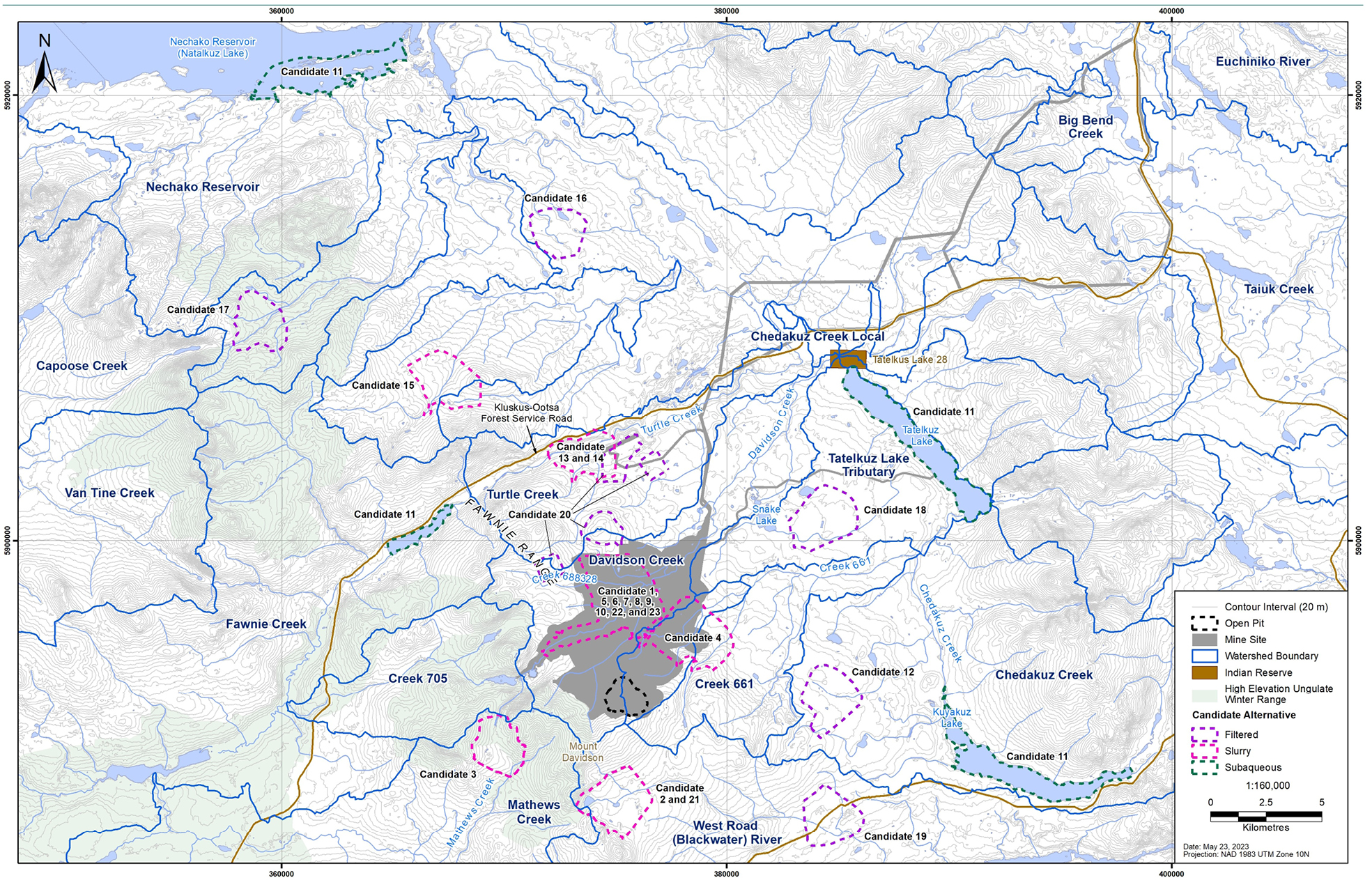
Figure 4: Tailings storage facility candidate alternatives - Text version
The map identifies the mine site at the bottom-centre in grey. Several Candidates for the Tailings Storage Facility (TSF) are located in the Project area: Candidates 1, 5, 6, 7, 8, 9, 10, 22 and 23 are in the same location, north of the open pit, Candidate 4 is located northwest of the open pit. The remaining Candidate options are located outside the Project location in other watersheds. The map also includes the watershed boundaries in the area that surround the Project location. An important geographic reference includes the Natalkuz Lake or Nechako Reservoir located northwest of the mine site at the top-left corner of the map.
Thirteen options were carried over for a high-level risk assessment to identify the lowest risk for different tailing technologies based on hazards related to safety, the environment, and technical execution. The 13 options were categorized into 3 different tailing technologies. The three options with the lowest overall risk for each category of tailing technologies were carried over for a multiple account analysis (MAA). A fourth option was also carried over for the MAA at the request of the B.C. Ministry of Energy and Mines. All four options (see Table 1) are located in the Davidson Creek watershed, which is close to the ore deposit. The MAA found that Option 1 performed the best for the technical, environmental, socio-economic, and project economic criteria, and it ranked second for the physical stability criterion.
| Option | Option description | Impact on rainbow trout habitat and spawning habitat (ha) | Proponent cost table b1 note * (in millions of dollars) |
|---|---|---|---|
| 1 | A thickened-slurry tailings (selected option described in further details in the Background section). | 3.5 | 225–523 |
| 2 | A filtered tailings that will be stacked in a waste pile on land and a PAG/NAG3 waste rock submergence impoundment that will be positioned downstream of the filtered tailings waste pile. The impoundment area was designed to permanently store PAG/NAG3 waste rock in a saturated condition. | 4.2 | More than 1,000 |
| 3 | An ultra-thickened tailings that will permanently store tailings and PAG/NAG3 waste rock in a saturated condition in one impoundment. | 3.6 | 350–572 |
| 4 | A filtered tailings that will be stacked in a waste pile on land in a partially saturated condition. The tailings waste pile is the same as option 2. The PAG/NAG3 waste rock will be stored in a separate engineered surface containment in a heaped arrangement. | 3.1 | More than 1,000 |
Table b1 note(s)
|
|||
Assessment of options for the disposal of NAG waste rock and overburden
The Proponent identified six options for NAG waste rock and overburden disposal (Figure 5) based on the threshold criterion of 10 km distance from the open pit, which was selected based on the cost of hauling waste rock and overburden from the open pit. A prescreening analysis eliminated two options that were not entirely within the Davidson Creek watershed and did not meet water management best practices. A third option was rejected because it was located more than 5 km from the open pit and, therefore, considered uneconomical due to transportation cost. A fourth option was rejected because it was located in the Blackwater watershed, which is a Heritage River under the B.C. Heritage Rivers System.
Figure 5: Non-acid generating waste rock and overburden stockpile alternatives
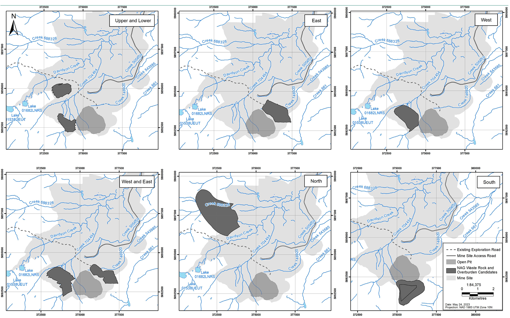
Figure 5: Non-acid generating waste rock and overburden stockpile alternatives - Text version
Two rows with three maps in each row of the mine site. Each individual map shows an option for the location of the ore stockpile configurations in relation to the location of the open pit at the bottom-centre of each map. The top-left corner start with the Upper and Lower configuration for two stockpiles to the northwest and west of the open pit, respectively. The top-centre map shows the East configuration of one stockpile immediately northeast of the open pit. The top-right map shows the West configuration of one stockpile immediately west of the open pit. The bottom-left map shows the West and East configuration of two stockpiles on either side of the open pit. The bottom-centre map shows the North configuration of one stockpile on the northwest side of the mine site, furthest from the open pit. The bottom-right map shows the South configuration of one stockpile immediately south of the open pit.
The Proponent developed an MAA to further characterize the two remaining options (see Table 2), both located in the Davidson Creek watershed to provide proximity to the ore deposit and the selected site for the TSF. The MAA found that Option 1 performed the highest for the technical and environmental criteria, and equally to Option 2 in regard to the socio-economic and economic criteria.
| Option | Option description | Impact on the rainbow trout habitat (ha) | Loss and risk to wetlands (ha) | Proponent cost |
|---|---|---|---|---|
| 1 | The upper and lower NAG waste rock and overburden stockpiles would involve the construction, operation and closure of two stockpiles (selected option described in further details in the Background section). | 0.23 | 7 |
|
| 2 | The west NAG waste rock and overburden stockpile would involve the construction, operation and closure of one waste rock stockpile. | 0.68 | 49 |
|
Assessment of options for the LGO stockpiles
The Proponent identified seven options (see Figure 6) for low-grade ore storage, all of which are located within 6 km of the open pit and are economically viable (i.e. the cost of transporting the ore to the stockpiles and the economics of the Project). The locations considered for LGO stockpiles were determined based on the selected locations for both the TSF and the NAG waste rock and overburden stockpiles.
A prescreening analysis rejected one option that was deemed uneconomical, three other options because they were either in the Blackwater watershed or were outside the Davidson Creek watershed, and a fifth option because of insufficient storage capacity and high transportation cost. The remaining two options were carried over for further analysis. The two LGO stockpile options (see candidate alternative no. 1 and no. 2 in Figure 6) are located in the same general area and use the same technology for their construction, operation, and closure. The analysis indicated that Option 1 was preferred because of better technical considerations and a 30 million dollars difference in transportation cost. Option 1 is expected to impact 1.1 ha of instream fish habitat, which would have not been frequented by fish anyway following the construction of the TSF main dam.
Figure 6: Low grade ore stockpile candidate alternatives
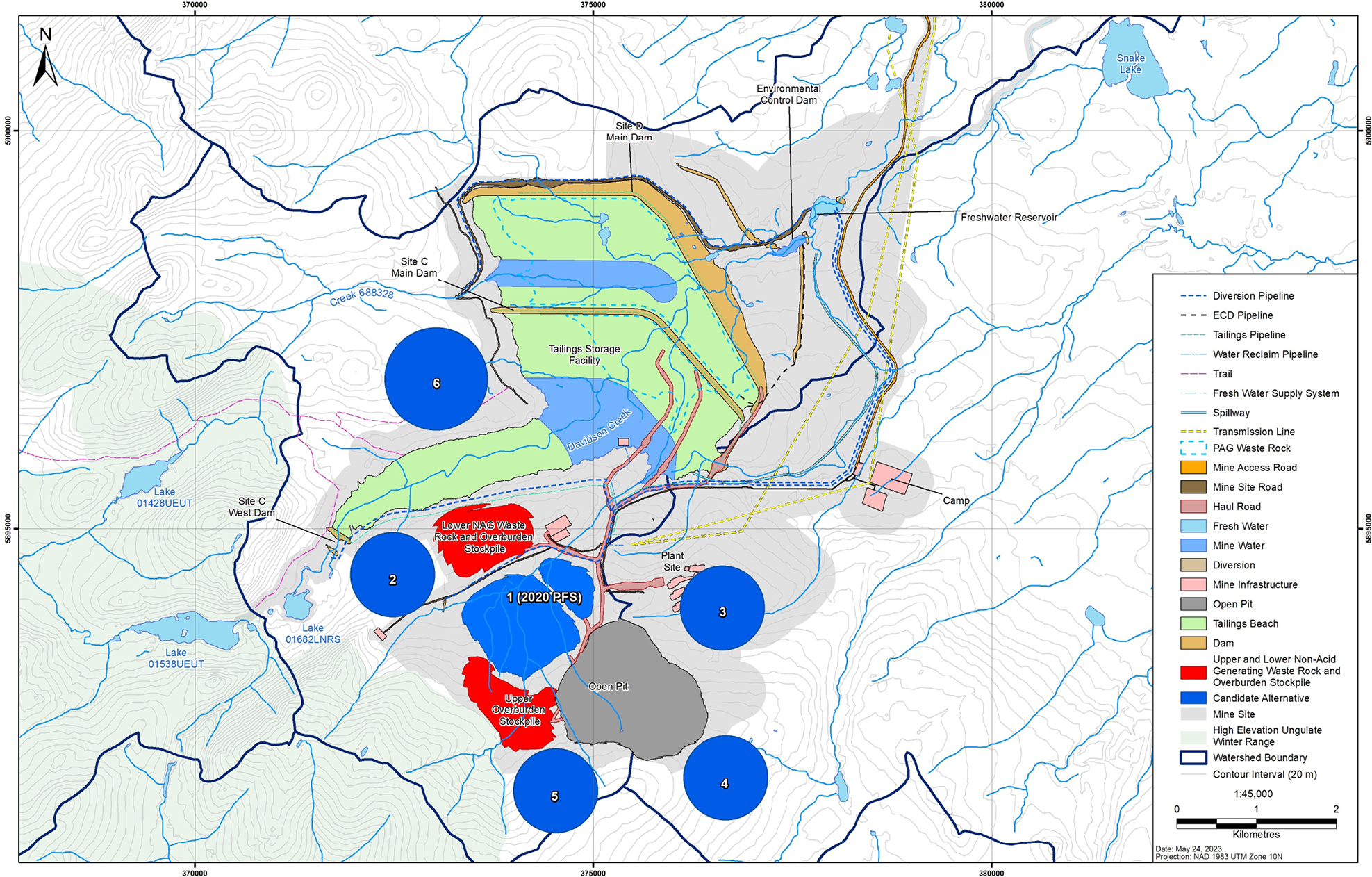
Figure 6: Low grade ore stockpile candidate alternatives - Text version
The locations of the candidate alternatives for the low-grade ore stockpiles in relation to the open pit, the Tailings Storage Facility (TSF) and the waste rock and overburden stockpiles. Starting at the top of the map and moving clockwise, Candidate 6 is the northern most option located to the west of the TSF. Candidate 3 is located northeast of the open pit and south of the TSF. Candidate 4 is located southeast of the open pit. Candidate 5 is located southwest of the open pit. Candidate 2 is located northwest of the open pit and immediately south of the western point of the TSF. Candidate 1 is located at the centre of all the other options, immediately northwest of the open pit, and between the Upper and Lower waste rock and overburden stockpiles, located south of the TSF.
Regulatory analysis
Benefits and costs
Analytical framework
The analysis below examines the incremental impacts of the Amendments on the environment, businesses (the Proponent) and the Government. While costs for the Proponent are known and monetized, it is not feasible to quantify and monetize benefits due to data limitations. As a result, the cost-benefit analysis reflects monetized costs and qualitatively described environmental impacts.
DFO determined that the FHCP proposed by the Proponent is appropriate and meets the principles of DFO’s Policy for Applying Measures to Offset Adverse Effects on Fish and Fish Habitat Under the Fisheries Act. These principles include, but are not limited to, restoring degraded fish habitat to improve conditions for the production of fish, enhancing fish habitat to improve conditions for the production of fish, and creating productive and sustainable fish habitat where none existed before. The cost and environmental impacts of the Amendments could change if the FHCP is subsequently amended to further accommodate Indigenous interests.
Environmental impacts
To quantify and characterize both fish habitat loss following the destruction of 24 water bodies and the fish habitat gain associated with the implementation of the FHCP, the Proponent used three different metrics:
- Surface area of affected instream habitat (in ha);
- Habitat unitsfootnote 8 (HU) to quantify change in fish habitat taking into account the habitat preferences and requirements of a species at varying life stages; and
- Surface area of the riparian habitatfootnote 9 (in ha). Impacts to riparian habitat were calculated based on anticipated areas of disturbance or loss of vegetation within streamside buffers that reflect the type of vegetation and the suitability and sensitivities of nearby in-stream habitats.
While avoidance and mitigation measures are planned by the Proponent to reduce the overall impacts to fish habitat, the deposit of tailings and rock into the 24 water bodies subject to these Amendments to Schedule 2 of the MDMER will result in an unavoidable permanent loss of 5.8 ha of instream rainbow habitat, 58 096 rainbow trout HU, and a loss of 51.3 ha of riparian habitat alongside fish-bearing water bodies. The assessment of habitat loss identified that the Davidson Creek watershed supports habitat for rainbow trout spawning/egg incubation, fry summer rearing, juvenile summer rearing and overwintering, but not for summer foraging. The Creek 661 watershed is only used by adult rainbow trout for spawning.
To compensate for the loss of rainbow trout habitat, the Proponent developed an FHCP (see Table 3 for the implementation schedule), which will be mostly implemented within Lhoosk’uz Dené Nation and Ulkatcho First Nation’s territories, with the exception of the Ormond Creek riparian offsetting which will be located on CSFN territories. The FHCP takes into consideration DFO’s hierarchy of preferences, feedback from First Nations, technical feasibility, biological relevance, certainty in success, and relative cost. It contains six compensation measures located in four distinct geographic areas, as shown in Figure 7. Below is a short description of each measure:
- Matthews Creek restoration and enhancement: The Proponent will restore and enhance degraded habitat from past agricultural practices along Mathews Creek, which is close to the watersheds that will be affected by the Project.
- Matthews Creek and Mid-Matthews Creek off-channel ponds: The Proponent will construct five off-channel ponds in the Mathews Creek watershed to provide overwintering habitat for rainbow trout, as well as habitat for other trout life stages.
- Chedakuz Creek (Dykam Ranch) restoration and enhancement: The Proponent will restore the bank in four discrete sections of the Chedakuz Creek, which has been degraded by past agricultural practices, primarily cattle grazing.
- Chedakuz Creek Tributaries (Dykam Ranch) Restoration and Enhancement: The Proponent will restore and enhance two unnamed tributaries of the Chedakuz Creek, which have been impacted by cattle grazing, leading to overwide channels, undefined banks and riparian vegetation loss.
- Chedakuz Creek (Dykam Ranch) off-channel ponds: The Proponent will construct three off-channel ponds in the Chedakuz Creek watershed to provide overwintering habitat for rainbow trout, as well as habitat for other trout life stages.
- Ormond Creek riparian offsetting: The Proponent will restore the vegetation community affected by wildfire and mountain pine beetle infestation along the Ormond Creek.
Overall, these compensation measures will alleviate productivity bottlenecks as well as restore and enhance degraded rainbow trout habitat for all life stages. It will also improve productivity of other fish species present in these water bodies, including burbot, brassy minnow, slimy sculpin, longnose dace, and white sucker. According to the FHCP, once fully implemented in 2026, these compensation measures will result in gain and/or restoration of 10.4 ha of rainbow trout instream habitat, 173 958 rainbow trout HU, and 100.3 ha of riparian habitat. These gains will therefore exceed the expected rainbow trout fish habitat loss.
Figure 7: Location of compensation measures under the FHCP
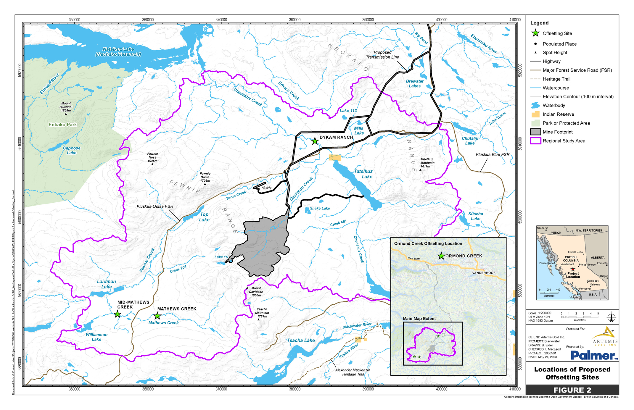
Figure 7: Location of compensation measures under the FHCP - Text version
The mine site is located at the centre of map. The Regional Study Area is shown by a perimeter outside of the mine site. Three stars identify the locations of the compensation measures. One star is located to the north of the mine, identified as Dykam Ranch. Two stars are located to the southwest on the mine, identified as Mid-Matthews Creek and Matthews Creek, respectively. The bottom-right corner of the map shows a larger scale map with a star located at the top to the west of the city of Vanderhoof and to the north of the mine site, identified as Ormond Creek. Important geographical reference points with respect to the Project location are also shown that include Entiako Park and Natalkuz Lake located northwest of the mine site, Tatelkuz Lake located northeast of the mine site and southeast of the Dykam Ranch site, and Tsacha Lake and the Alexander Mackenzie Heritage Trail located south of the mine site.
Cost to business
The implementation of the FHCP to compensate for the destruction of 57.1 ha of fish habitat will cost $13.7 millionfootnote 10 to BW Gold Ltd. Table 3 describes the estimated costs associated with the implementation of the FHCP. These estimated costs could change if the scope of the FHCP were to be revised.
| Description | Undiscounted amount in 2022 Canadian dollars | Amount discounted at a ratetable 1 note 1 of 3% | Proposed schedule |
|---|---|---|---|
| Land acquisition or leasing | $13,000 | $11,000 | 2023–2035 |
| Construction | $12,356,000 | $11,767,000 | 2023–2026 |
| Monitoring and maintenance | $1,321,000 | $989,000 | 2027–2036 |
| Total | $13,690,000 | $12,767,000 | 2023–2036 |
Table 1 Notes
|
|||
Note: Costs are rounded to the nearest thousands. The “construction” and “monitoring and maintenance” cost categories are inclusive of contingency and inflation protection cost.
Cost to government
Government of Canada enforcement activities include inspections to monitor the implementation of the FHCP, which may have associated incremental costs. Specifically, there may be site visits, monitoring and review costs incurred by the DFO. These incremental costs will be low, given that monitoring activities and associated costs will only occur intermittently during the implementation of the FHCP and will not continue throughout the life of the mine waste disposal areas and will diminish significantly following the publication of the Amendments in the Canada Gazette. Incremental compliance promotion costs, if incurred, will also be low given that compliance promotion activities occurred throughout the federal environmental assessment process. Therefore, the total incremental costs to the Government of Canada associated with the proposed FHCP will be low.
Table 4: Cost-benefit statement
| Impact | Stakeholder | Total (present value) | Annualized average (10 years) |
|---|---|---|---|
| Costs | BW Gold Ltd. | 12.77 | 1.50 |
| Impact | Stakeholder | Description |
|---|---|---|
| Positive impacts | Indigenous peoples, general public | The loss of fish habitat associated with the disposal of tailings and waste rock will be offset by the implementation of a compensation plan and will result in the creation of 110.7 ha of fish habitat (10.4 ha of rainbow trout instream habitat and 100.3 ha of riparian habitat). |
| Negative impacts | Indigenous peoples, general public | The loss of fish habitat associated with the disposal of tailings and waste rock amounts to 57.1 ha of fish habitat (5.8 ha of rainbow trout instream habitat and 51.3 ha of riparian habitat). |
Small business lens
There are no impacts on small business associated with the Amendments. BW Gold Ltd., the owner and operator of the mine, does not meet the definition of small business as set out in the Policy on Limiting Regulatory Burden on Business.
One-for-one rule
The one-for-one rule does not apply, as there is no incremental change in the administrative burden on businesses.
Regulatory cooperation and alignment
This initiative is not related to a work plan or commitment under a formal regulatory cooperation forum and, therefore, does not need to align or cooperate with external regulatory frameworks.
Strategic environmental assessment
A strategic environmental assessment concluded that authorizing the disposal of tailings in a TIA will have adverse environmental effects, namely, the loss of fish habitat. However, these adverse environmental effects will be offset by the implementation of a FHCP that will result in no net loss of fish habitat. The Proponent must also submit an irrevocable letter of credit or equivalent financial guarantee covering the implementation costs of the plan, including the costs of any corrective measures necessary if the objective of the plan is not achieved.
Gender-based analysis plus (GBA+)
Provided the FHCP is fully implemented, the Department of the Environment has determined that the Amendments are not expected to disproportionately affect Indigenous peoples, or any other socio-demographic group.
Implementation, compliance and enforcement, and service standards
The Amendments come into force on the day on which they are registered. The Amendments will designate the use of certain water bodies that are frequented by fish for disposal of tailings and mine rock generated from the activities of the Blackwater Project. BW Gold Ltd. will only receive authorization to deposit mine waste once an FHCP has been approved and all conditions under section 27.1 of the MDMER have been met.
Given that the MDMER are made pursuant to the Fisheries Act, enforcement officers will, when verifying compliance with the MDMER, act in accordance with the Compliance and enforcement policy for habitat and pollution provisions of the Fisheries Act (hereinafter, the Policy). The Policy sets out principles of fair, predictable, and consistent enforcement that govern the application of the Fisheries Act and its regulations.
Verification of compliance with the MDMER and the Fisheries Act will include, among other inspection activities, site visits, sample analysis and related reports associated with the proposed Amendments. An enforcement officer may conduct an investigation when there are reasonable grounds to believe that an offence is being or has been committed.
As set out in the Policy, if there were evidence of an alleged offence, enforcement officers would determine an appropriate enforcement action, in accordance with the following criteria:
- The nature of the alleged violation: Factors to be considered include the seriousness of the damage or potential damage to fish habitat, the fishery resource, or the risks associated with the human use of fish, the intent of the alleged violator, whether it is a repeated occurrence, and whether there were attempts to conceal information or otherwise circumvent the objectives and requirements of the Act and its regulations.
- Effectiveness in achieving the desired result with the alleged violator: The desired result is compliance with the Act in the shortest possible time and with no further occurrence of violations, and factors to be considered include the history of compliance with the Fisheries Act, willingness to cooperate with enforcement personnel, evidence and extent of corrective action already taken, and the existence of enforcement actions by other federal or provincial/territorial authorities.
- Consistency in enforcement: Enforcement officers will consider how similar situations are being or have been handled in determining the measure to take.
The Policy sets out the range of possible responses to alleged violations, including issuance of warnings, directions, authorizations, and ministerial orders, without resorting to court action; and/or court actions, such as injunctions, prosecution, court orders upon conviction, and civil suits for recovery of costs.
Contacts
Nicole Folliet
Acting Executive Director
Mining and Processing Division
Industrial Sectors and Chemicals Directorate
Environment and Climate Change Canada
351 Saint-Joseph Boulevard
Gatineau, Quebec
K1A 0H3
Email: mdmer-remmmd@ec.gc.ca
Maria Klimas
Acting Director
Regulatory Analysis and Valuation Division
Economic Analysis Directorate
Environment and Climate Change Canada
200 Sacré-Cœur Boulevard
Gatineau, Quebec
J8X 4C6
Email: ec.darv-ravd.ec@canada.ca