
Regulations Amending the Metal and Diamond Mining Effluent Regulations: SOR/2020-108
Canada Gazette, Part II, Volume 154, Number 12
Registration
SOR/2020-108 May 20, 2020
FISHERIES ACT
P.C. 2020-332 May 18, 2020
Her Excellency the Governor General in Council, on the recommendation of the Minister of the Environment, pursuant to subsection 36(5) of the Fisheries Act footnote a, makes the annexed Regulations Amending the Metal and Diamond Mining Effluent Regulations.
Regulations Amending the Metal and Diamond Mining Effluent Regulations
Amendment
1 Schedule 2 to the Metal and Diamond Mining Effluent Regulations footnote 1 is amended by adding the following in numerical order:
| Item |
Column 1 |
Column 2 |
|---|---|---|
49 |
All waters located within the area described in column 2, located approximately 9 km southeast of the township of Dubreuilville, Ontario |
The waters located within an area located approximately 9 km southeast of the township of Dubreuilville, Ontario. More precisely, the area bounded by five straight lines connecting five points starting at the point located at 48°17′49.226″ north latitude and 84°29′53.100″ west longitude to the point located 528.5 m to the northeast at 48°17′54.428″ north latitude and 84°29′28.669″ west longitude to the point located 941 m southwest at 48°17′30.407″ north latitude and 84°29′56.752″ west longitude to the point located 315 m southwest at 48°17′25.646″ north latitude and 84°30′10.300″ west longitude to the point located 420.5 m southwest at 48°17′21.475″ north latitude and 84°30′29.717″ west longitude and ending at the point located 1142.1 m northeast at 48°17′49.226″ north latitude and 84°29′53.100″ west longitude. |
50 |
All waters located within the area described in column 2, located approximately 9 km southeast of the township of Dubreuilville, Ontario |
The waters located within an area located approximately 9 km southeast of the township of Dubreuilville, Ontario. More precisely, the area bounded by five straight lines connecting five points starting at the point located at 48°17′27.821″ north latitude and 84°29′29.968″ west longitude to the point located 981.6 m to the southeast at 48°16′56.049″ north latitude and 84°29′28.918″ west longitude to the point located 221.7 m southwest at 48°16′48.986″ north latitude and 84°29′30.841″ west longitude to the point located 1062.4 m northwest at 48°16′50.640″ north latitude and 84°30′22.311″ west longitude to the point located 1146.3 m northeast at 48°17′22.053″ north latitude and 84°29′52.707″ west longitude and ending at the point located 501.4 m northeast at 48°17′27.821″ north latitude and 84°29′29.968″ west longitude. |
51 |
All waters located within the area described in column 2, located approximately 9 km southeast of the township of Dubreuilville, Ontario |
The waters located within an area located approximately 9 km southeast of the township of Dubreuilville, Ontario. More precisely, the area bounded by four straight lines connecting four points starting at the point located at 48°17′5.633″ north latitude and 84°29′5.605″ west longitude to the point located 306.5 m southeast at 48°16′55.717″ north latitude and 84°29′5.083″ west longitude to the point located 245.7 m northwest at 48°16′58.236″ north latitude and 84°29′16.385″ west longitude to the point located 196.7 m northwest at 48°17′4.263″ north latitude and 84°29′19.471″ west longitude and ending at the point located 289 m northeast at 48°17′5.633″ north latitude and 84°29′5.605″ west longitude. |
52 |
All waters located within the area described in column 2, located approximately 9 km southeast of the township of Dubreuilville, Ontario |
The waters located within an area located approximately 9 km southeast of the township of Dubreuilville, Ontario. More precisely, the area bounded by eight straight lines connecting eight points starting at the point located at 48°17′55.528″ north latitude and 84°27′49.712″ west longitude to the point located 581.3 m southeast at 48°17′50.542″ north latitude and 84°27′22.518″ west longitude to the point located 915.2 m southwest at 48°17′21.168″ north latitude and 84°27′28.342″ west longitude to the point located 1039.1 m southwest at 48°16′55.207″ north latitude and 84°28′0.398″ west longitude to the point located 458 m southwest at 48°16′48.549″ north latitude and 84°28′20.249″ west longitude to the point located 575.5 m northwest at 48°16′56.999″ north latitude and 84°28′45.128″ west longitude to the point located 439.2 m northeast at 48°17′11.207″ north latitude and 84°28′44.376″ west longitude to the point located 1158.6 m northeast at 48°17′42.340″ north latitude and 84°28′13.026″ west longitude and ending at the point located 629.9 m northeast at 48°17′55.528″ north latitude and 84°27′49.712″ west longitude. |
Coming into Force
2 These Regulations come into force on the day on which they are registered.
REGULATORY IMPACT ANALYSIS STATEMENT
(This statement is not part of the Regulations.)
Summary
Issues: Prodigy Gold Inc. (Proponent) is proposing to develop an open-pit gold mine near Wawa, Ontario. The Proponent will construct a tailings management facility, a mine rock management facility and overburden stockpile areas to manage the waste generated by the mining operations that will destroy 21 water bodies that are frequented by fish. The Fisheries Act prohibits the deposit of deleterious substances into waters frequented by fish, unless authorized by regulation. The Metal and Diamond Mining Effluent Regulations (MDMER) include provisions to allow for the disposal of mine waste in waters frequented by fish.
Description: The Regulations Amending the Metal and Diamond Mining Effluent Regulations (the Amendments) will add four geographical areas to Schedule 2 of the MDMER that encompass 21 water bodies, designating them as tailings impoundment areas (TIAs) and authorizing their use for the disposal of mine waste.
Rationale: The Proponent assessed several options to determine the preferred disposal method and site location to manage mine waste, taking into account environmental, technical, economic and socio-economic factors. The Proponent prepared an assessment of alternatives report in accordance with the Department of the Environment’s Guidelines for the assessment of alternatives for mine waste disposal. Regulatory options include those options that would result in the destruction of fish-frequented waters while non-regulatory options include those that do not impact waters frequented by fish (i.e. land-based options).
The site locations for the tailings management facility, the mine rock management facility and the overburden stockpiles were selected on the basis of minimizing environmental impacts and on the interests of Indigenous and local communities (e.g. loss of forestry resources and hunting/trapping opportunities).
The MDMER require that the Proponent develop and implement a fish habitat compensation plan (FHCP) to offset the loss of fish and fish habitat resulting from the disposal of mine waste (i.e. tailings, waste rock and overburden) in waters frequented by fish.
The Department of the Environment consulted Indigenous groups, the general public and other interested parties that may be adversely impacted by the Magino Mine Project. Impacted Indigenous groups and the municipality of Wawa are supportive of the selected site for the tailings management facility and of measures proposed by the Proponent to offset the loss of fish habitat.
The Proponent will incur costs associated with the implementation of the FHCP that will offset the loss of 44.96 hectares (ha) of fish habitat associated with the disposal of mine waste for the Magino Mine Project. The implementation of the FHCP will result in a direct gain of 47.25 ha of fish habitat and is estimated to cost $18,100,000. footnote 2
Issues
Prodigy Gold Inc. (the Proponent) is proposing to develop an open-pit gold mine located in Ontario, approximately 40 kilometres (km) northeast of Wawa and 195 km north of Sault Ste. Marie, Ontario (see Figure 1).
The Proponent intends to use 21 water bodies frequented by fish to dispose of mine waste (tailings, waste rock, and overburden) that will be generated by mining operations. Subsection 36(3) of the Fisheries Act (Act) prohibits the deposit of deleterious substances into waters frequented by fish, unless authorized by regulation. The MDMER, made pursuant to subsections 34(2), 36(5) and 38(9) of the Act, include provisions to allow for the disposal of mine waste in waters frequented by fish.
Background
Metal and Diamond Mining Effluent Regulations
The MDMER, which came into force on June 1, 2018, footnote 3 prescribe the maximum authorized limits for deleterious substances in mine effluent in Schedule 4 (e.g. arsenic, copper, cyanide, lead, nickel, zinc, radium-226 and total suspended solids). The MDMER also specify the allowable acidity or alkalinity (pH range) of mine effluent and require that mine effluent not be acutely lethal to fish. footnote 4 The MDMER further require that mine owners and operators sample and monitor effluents to ensure compliance with the authorized limits and to determine any impact on fish, fish habitat and fishery resources. The Department of the Environment publishes annual performance summaries for metal mines with respect to selected standards prescribed by the MDMER.
The use of waters frequented by fish for mine waste disposal can only be authorized through an amendment to the MDMER by listing the water body in Schedule 2, designating it as a TIA. As of January 2020, 48 water bodies were listed in Schedule 2.
Section 27.1 of the MDMER requires the development and implementation of an FHCP to offset the loss of fish habitat that would occur as a result of the use of a fish-frequented water body for mine waste disposal. The owner or operator of a mine is also required to submit an irrevocable letter of credit to ensure that funds are in place should the owner or operator fail to address all the elements of the FHCP.
For any project where the proposed mine waste disposal (including effluents) would affect fish-frequented waters, proponents must consider alternatives for mine waste disposal and demonstrate that the preferred option is the best option based on environmental, technical, economic and socio-economic criteria specified in the Department of the Environment’s Guidelines for the assessment of alternatives for mine waste disposal. As part of these guidelines, proponents must also undertake preliminary consultations on how alternative mine waste disposal options were assessed and how the preferred option was determined.
The Magino Mine Project
The Proponent is proposing to develop an open-pit gold mine located in Ontario, approximately 10 km southeast of Dubreuilville, 40 km northeast of Wawa, and 195 km north of Sault Ste. Marie.
Figure 1: Location of the Magino Mine Project
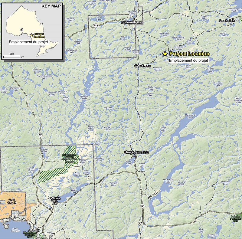
Image description
Figure 1 is a map showing the location of the Magino Mine Project in Ontario. The Figure also identifies key geographical references that include the township of Dubreuilville located northwest of the project location, the town of Goudreau located southwest of the project location, and the township of Wawa located southwest from the project location.
The Magino Mine Project (Project) is a brownfield site that contains a past-producing underground gold mine, associated infrastructure, landfill, tailings facility and polishing pond. The Project will involve the mining of up to approximately 150 million tonnes of ore and approximately 430 million tonnes (Mt) of mine rock from an open pit in the same location as the previous underground mine and will operate over approximately 18 to 21 years, including construction, operations, and decommissioning. The Proponent is projecting an investment of $561 million (USD) related to the construction of the Project and around $100 million (USD) in operational expenditures annually.
The Proponent undertook an assessment of alternatives for the storage of tailings, mine rock and overburden based on the Guidelines. The Proponent’s technical report (PDF) footnote 5 describes the steps undertaken to assess the alternatives for the management of waste generated by the Magino Mine Project.
Management of mine waste at the Magino Mine
The waste generated from the Magino Mine Project will be comprised of tailings, mine rock, and overburden. As such, the proposed mine plan includes the development of the following facilities and structures.
- A tailings management facility (TMF) (390 ha surface area) will be designed to contain up to 150 Mt of tailings, a by-product of ore processing. The TMF will include containment dams, dykes, a reclamation pond and a mine water collection system and have a maximum height of 80 metres (m). The construction of the TMF will destroy 17.38 ha of water bodies frequented by fish.
- The excess mine rock not used for construction activities or backfill will be stockpiled in a mine rock management facility (MRMF) (360 ha surface area) with a capacity of 430 Mt of mine rock and a maximum height of 85 m. The MRMF will destroy 17.63 ha of water bodies frequented by fish.
- A water quality control pond (WQCP) will be constructed to receive all mine contact water from the site with a single point of discharge of excess water to the receiving environment. The water bodies destroyed by the WQCP are accounted for under the TMF.
- The development of the open pit and excavation of the tailing management facility is expected to result in the excavation of up to 3 million mfootnote 3 of top soil and 23 Mt of overburden at the early stage of the Project development. The top soil and a portion of the overburden will be stockpiled for future site reclamation during the operation stage. The total surface area of the stockpiles will be approximately 60 ha and will destroy 9.95 ha of water bodies frequented by fish.
The disposal of mine waste (tailings, waste rock and overburden) will destroy 21 water bodies or portions of water bodies that are frequented by fish, totalling approximately 44.96 ha of fish habitat.
The Department of Fisheries and Oceans (DFO) determined that the construction of the TMF, the WQCP, and the MRMF and overburden stockpile areas will result in direct and indirect fish habitat losses resulting in serious harm to fish. The Proponent is required to obtain an authorization under paragraph 35(2)(b) of the Fisheries Act from DFO prior to proceeding with the site development. A condition of this authorization is to offset any death to fish and/or harmful alteration, disruption or destruction of fish habitat.
The Proponent proposed a combined compensation/offsetting plan to satisfy the requirements under both the MDMER and section 35 of the Fisheries Act.
Environmental assessment of the Magino Mine Project
The Project was subject to both a Provincial Class Environmental Assessment (EA) under Ontario’s Environmental Assessment Act and a federal EA under the former Canadian Environmental Assessment Act, 2012. The Ontario Ministry of Environment and Climate Change and the former Canadian Environmental Assessment Agency (now referred to as the Impact Assessment Agency of Canada – IAAC) agreed to coordinate the federal and provincial EAs to the extent possible pursuant to the Canada-Ontario Agreement on Environmental Assessment Cooperation. Therefore, the Proponent submitted a single Environmental Impact Statement (EIS) to meet both provincial and federal requirements.
On January 24, 2019, the Minister of the Environment issued an EA Decision Statement indicating that the proposed Project is not likely to cause significant adverse environmental effects referred to in subsections 5(1) and (2) of the former Canadian Environmental Assessment Act, 2012. In March 2019, the Ontario Ministry of Natural Resources and Forestry concluded its EA for the Project and issued a Statement of Completion.
Objective
The objective of the amendments is to authorize the destruction of water bodies frequented by fish from the disposal of mine waste generated by the Magino Mine Project. A requirement to this authorization is for the Proponent to offset the loss of fish and fish habitat by developing and implementing a FHCP.
Description
Regulatory amendments
The amendments will add four geographical areas to Schedule 2 of the MDMER (see Figure 2) that encompass 21 water bodies, designating them as TIAs and authorizing their use for the disposal of mine waste. This will result in the loss of 44.96 ha of fish habitat.
Another 14.8 ha of fish habitat relates to the site development, including the open pit, processing plant and construction of access roads, activities that will be authorized and offset under section 35 of the Fisheries Act. In total, 59.76 ha of fish habitat will be impacted by the Project (TIA and mining operations).
Figure 2: Location of water bodies to be listed in Schedule 2 of the MDMER
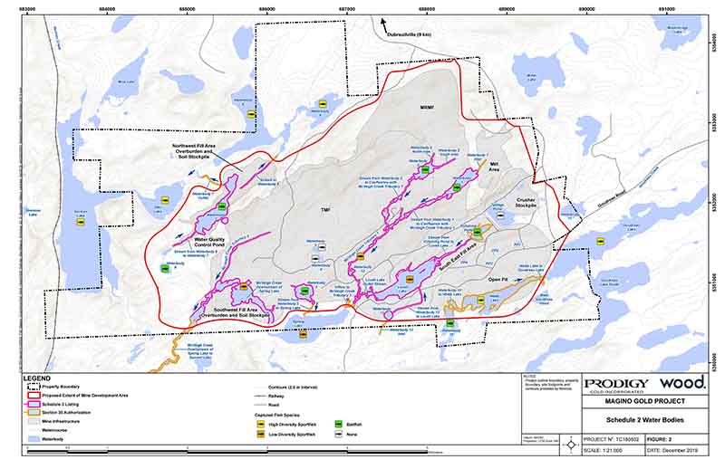
Image description
Figure 2 is a 1:21,000 scale map showing the location of the 21 water bodies, or portions of water bodies, to be listed in Schedule 2 of the MDMER. The map also shows key mining infrastructure that will impact the water bodies that include the Tailings Management Facility, the Waste Rock Storage Facility and the overburden and soil stockpile areas.
Figure 3: Polygons encompassing the impacted water bodies
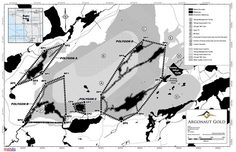
Image description
Figure 3 is a map showing the 21 water bodies to be listed in Schedule 2 of the MDMER. The water bodies that are close to each other are grouped into four geographical areas, or polygons. The four Polygons are identified as Polygons A, B, C and D. The figure also identifies key mining infrastructure that include the Tailings Management Facility , the open pit, the mill area, the dam for the Tailing Management Facility, overburden and soil stockpiles, the water quality control pond and the crusher stockpile.
DFO determined that the FHCP proposed by the Proponent is appropriate and meets the guiding principles of DFO’s Fisheries Productivity Investment Policy: A Proponent’s Guide to Offsetting.
Regulatory development
Instrument choice (regulatory and non-regulatory options considered)
Non-regulatory options would involve the disposal of tailings in a manner that would not impact fish-frequented water bodies (i.e. land-based options). Regulatory options correspond to those that would result in the destruction of waters frequented by fish.
The Proponent developed several options in its assessment to determine the best option for mine waste disposal. The report entitled Magino Gold Project, Mine Waste Alternatives Assessment, November 2018 (PDF) takes into account the environmental, technical, economic and socio-economic factors and was conducted in accordance with the Department of the Environment’s Guidelines for the assessment of alternatives for mine waste disposal.
Site options for the tailings management facility
The Proponent identified ten potential sites for the location of the tailings management facility (TMF), including one site (i.e. Site C) that would not directly impact fish-frequented water bodies. Table 1 below provides a brief description of the sites considered for the TMF location.
| Option |
Description |
|---|---|
Site A |
An estimated 1,700 m (linear) of streambed would be destroyed and has potential to extend impacts to three additional watersheds; used for recreational purposes by the residents of Dubreuilville; 12 km access road would be required to accommodate pipeline routing from the proposed plant site. |
Site B |
An estimated 500 m (linear) of streambed would be destroyed and has potential to extend impacts to two additional watersheds; used for recreational purposes; 7.0 km access would be required to accommodate pipeline routing from the proposed plant site. |
Site C (non-regulatory option) |
No waters frequented by fish would be destroyed; 8.7 km access road would be required to accommodate pipeline routing from the proposed plant site; site characterized by mineral and forest land use. |
Site D |
Contained within the downstream portion of the Webb-Goudreau watershed; located on a former iron ore-mining site and was seriously impacted by those operations; 7.1 km access road would be required to accommodate pipeline routing from the proposed plant site. |
Site E |
Potential to impact the lower portion of the Webb-Goudreau watershed; an estimated 4,720 m (linear) of stream bed would be destroyed as well as five water bodies, including Teare Lake, which has been impacted by previous mining operations. |
Site F |
An estimated 3,800 m (linear) of streambed would be destroyed and has potential to impact two watersheds; historic Goudreau cemetery would be destroyed which is considered a site of special significance for Indigenous groups. Moreover, the location is not preferred by Indigenous groups and local communities. |
Site G |
Only option fully contained within the boundary of the mine property; two wetlands and an estimated 4,697 m (linear) of streambed would be destroyed, mainly the upper reaches of McVeigh Creek, which is considered poor fish habitat; tailings and return water pipelines and associated access roads would not require any stream crossings. |
Site H |
An estimated 700 m (linear) of streambed would be destroyed and has potential to extend impacts to two additional watersheds west of Dubreuilville; an estimated 11.9 km access road would be required to accommodate pipeline routing from the proposed plant site. |
Site I |
An estimated 2,460 m (linear) of streambed would be destroyed and has potential to impact two watersheds; an estimated 3.9 km access road would be required to accommodate pipeline routing from the proposed plant site. |
Site J |
An estimated 3,100 m (linear) of streambed would be destroyed and has potential to impact three watersheds; an estimated 9.3 km access road would be required to accommodate pipeline routing from the proposed plant site. |
Following the pre-selection stage, six of the ten options considered were rejected due to their physical distance from the proposed mill location, ownership of the land, Indigenous and local residents land use and potential difficulties associated with water management. The four remaining options (i.e. sites C, E, G, I) were analyzed in greater detail.
The final analysis applied environmental indicators such as potential effects on fish and fish habitat, loss of wetland habitat, and risk of collision with wildlife among others. Technical indicators applied included the complexity of the water management system for the tailings management facility, factors related to the embankment design and site access as it related to safety. The economic indicators applied costs related to the life of the project, the implementation of the FHCP, land acquisition while socio-economic indicators included community acceptance and land use (i.e. hunting, trapping and fishing opportunities) by First Nations and local communities.
The final analysis concluded that site G was the most appropriate considering the above described environmental, technical, and economic considerations. Site G will allow for the most compact project footprint, the largest storage capacity and was considered to have the lowest potential for effects to water quality, terrestrial and atmospheric environments. From a socio-economic perspective, Site G will minimize the impacts on the receiving environment and on Indigenous and local communities (e.g. loss of forestry resources and hunting/trapping opportunities).
Tailings deposition methods
Table 2 below lists the six options for tailings disposal methods identified by the Proponent for consideration.
| Option |
Tailings disposal method |
|---|---|
1 |
In-pit tailings disposal |
2 |
Dry stack tailings disposal |
3 |
Surface paste tailings disposal |
4 |
Thickened tailings disposal |
5 |
Conventional tailings disposal |
6 |
Co-disposal of tailings and mine rock |
Both thickened tailings disposal (Option 4) and conventional tailings disposal (Option 5) were considered as viable. Thickened tailings was assessed as the preferred method because of the environmental benefits it offers in minimizing fresh water demand and site water management. The other options were rejected because they were either not feasible, did not confer a significant benefit over conventional technology and/or did not reduce the risk for cost increase.
The Proponent’s final analysis determined that site G, with thickened tailings disposal method, was the preferred overall option for the TMF.
Options for the mine rock management facility
The ten locations proposed for the TMF (see Table 1) were also considered for the mine rock management facility (MRMF) using the same assessment criteria for pre-screening. Four options (i.e. Site C, Site E, Site G and Site I) passed the pre-screening and were analyzed in greater detail. These sites could all accommodate the stockpiling of over 250 million tonnes of mine rock.
Site G was assessed as the preferred site for the location of the MRMF. An additional consideration for site G is the added safety factor that the MRMF will bring to the TMF embankment’s long-term stability.
Options for the location of overburden stockpiles
Four sites were selected for consideration for overburden stockpiles (See Table 3) with site 3 and site 4 being the non-regulatory options as not destroying water bodies or streambeds. Table 3 below briefly describes the candidate locations for overburden stockpiles.
| Option |
Description |
|---|---|
Site 1 |
Located west of the TMF embankment: total footprint of approximately 32 ha with no meaningful increase in the size of the overall project footprint. |
Site 2 |
Located north of the MRMF and northeast of the WQCP: total footprint of approximately 34 ha with no meaningful increase in the size of the overall project. Stockpiling of overburden in this area would require an expansion to the north, resulting in destruction of the remaining portion of waterbody 7 not destroyed by the construction of the WQCP, as well as a smaller stream currently draining water body 7. |
Site 3 |
Located north of the public bypass road, within the cadastral boundaries of the Project site; total footprint of approximately 67 ha and would result in a slight increase in the overall project footprint; would not destroy water bodies or streambeds. |
Site 4 |
Located north of the Goudreau public road, just west of Mountain Lake; would not destroy any water bodies or streambeds but would result in a significant increase in the overall project footprint beyond the existing project property boundary; could result in additional impacts to land use by Indigenous and local community members, primarily forestry and hunting activities. |
The criteria applied during the pre-screening process were the storage capacity and compliance with the requirements of the Project’s mine plan. Three options (i.e. a combined site 1 and 2, site 3, and site 4) met these criteria and were carried forward for further analysis.
The final analysis included the application of environmental indicators such as the distance from the open pit, whether new water bodies would be impacted by runoff, whether additional streambeds would be destroyed, loss of terrestrial habitat and vegetation and risk to wildlife. Technical indicators applied included the length of the ditch required for runoff collection and the number of water quality control ponds that would be required to discharge to the receiving environment. Economic indicators applied to the analysis included the haulage cost and land ownership while socio-economic indicators included the loss of forestry resources and hunting/trapping opportunities and the use of public roads for site access.
The results of the final analysis concluded that a combination of sites 1 and 2, incorporated it into the design and construction of the embankment for the TMF, is the preferred location for an overburden stockpile.
Consultation
Indigenous engagement
Indigenous groups within or near the Project that may be adversely impacted were identified and consulted during both the federal and provincial EA processes as well as during the regulatory development phase related to these amendments. Local and traditional knowledge about the Project location was considered in the identification of potential environmental effects.
During the federal EA process, the Proponent undertook an assessment of potential impacts on Aboriginal and treaty rights related to current traditional land use and practice of rights. Taking into account key mitigation measures that address adverse environmental effects, the Impact Assessment Agency of Canada is of the view that the Project’s potential impacts on Aboriginal or treaty rights have been adequately identified and appropriately mitigated or accommodated for the purpose of decision-making under the former Canadian Environmental Assessment Act, 2012.
In relation to the location of the TMF, Indigenous groups, including Batchewana, Missanabie Cree First and Michipicoten First Nations and the Métis Nation of Ontario identified areas of traditional land use and cultural practices that could be potentially affected by the construction of the tailings management facility. The Proponent considered all information provided by Indigenous groups in selecting the preferred site of the tailings facility.
The Department of the Environment consulted with the Indigenous groups within or near the Project that may be adversely impacted by the Amendments. Consultations were also undertaken with the general public and other stakeholders and are summarized below.
Face-to-face consultation sessions with Batchewana, Missanabie Cree, Michipicoten, Garden River First Nations and the Métis Nation of Ontario took place between November 2018 and May 2019. Two public sessions took place in November 2018 in Dubreuilville and in Wawa. The Red Sky Independent Métis Nation was consulted via teleconference over the winter 2019.
The consultation sessions provided participants with information related to: how options to manage mine waste were assessed; compensation for the loss of fish habitat; information on the regulatory process; and how the FHCP is assessed by DFO. Participants had the opportunity to ask questions, express any concerns and were invited to submit comments in writing following the meetings.
The Department of the Environment also consulted on the possibility of applying the policy on Streamlining the Approvals Process for Metal Mines with Tailings Impoundment Areas for the purpose of streamlining timelines for the approval of the TIA authorization. As the conditions of the policy were met, the amendments to list the water bodies to Schedule 2 of the MDMER is exempt from pre-publication in Part I of the Canada Gazette.
Following the face-to-face meetings held with Indigenous groups, Batchewana, Missanabie and Michipicoten First Nations, as well as the Métis Nation of Ontario sent letters to the Department of the Environment indicating their support for the amendments and requested that ECCC conclude the regulatory process in a timely manner.
Furthermore, the Proponent has concluded Impact and Benefit Agreements (IBAs) with Batchewana, Michipicoten and Missanabie First Nations, as well as the Métis Nation of Ontario and the Red Sky Independent Métis Nation. These IBAs are privately negotiated agreements that establish the commitment and responsibilities of the impacted Indigenous communities and the mine proponent. Generally, IBAs seek to address the potentially adverse effects of development activities on Indigenous communities and ensure social and economic benefits for these communities.
Public engagement
Two public sessions were held in Dubreuilville and Wawa. There was no participation from members of the public at the Dubreuilville session, while the Wawa session had some participation. During the public session in Wawa members of the public did not raise any concerns with respect to the proposed mine disposal site and FHCP.
The Municipality of Wawa, the Corporation of the Township of Dubreuilville and the Corporation of the Township of White River sent letters, in December 2018, to the Department of the Environment in support for the Project and asking for an expeditious conclusion to the regulatory process.
Modern treaty obligations
An assessment of modern treaty implications was not conducted because no modern treaties are in place in or near the Project area. The Project is situated within the Robinson-Superior Treaty Area. footnote 6 Therefore, signatories to the Robinson-Superior Treaty, as described above, were consulted throughout the federal and provincial EA processes as well as on the Amendments.
Regulatory analysis
Benefits and costs
Analytical framework
The Amendments will list four geographic areas that encompass specific fish-frequented water bodies in Schedule 2 of the MDMER, thereby authorizing the Proponent to use them for the disposal of mine waste. The Proponent developed a FHCP meeting DFO’s Fisheries Productivity Investment Policy: A Proponent’s Guide to Offsetting, which means that the offsetting measures
- are scaled such that they are proportional to the impacts caused by the projects;
- provide additional benefits to fisheries productivity; and
- should strive to generate self-sustaining benefits to fisheries productivity (benefits to the fisheries should last at least as long as the impacts from the development project).
The analysis below examines the incremental impacts of the Amendments on the environment, businesses (i.e. the Proponent), and the Government. While costs for the Proponent are known and monetized, it is not feasible to quantify and monetize benefits due to data limitations. As a result, the cost-benefit analysis reflects monetized costs and qualitatively described impacts.
The cost and environmental impacts of the amendments could change if the scope of the FHCP was to be subsequently amended.
Environmental impacts
The disposal of mine waste (tailings, waste rock, and overburden) will impact 21 water bodies or portions of water bodies that are frequented by fish and totalling 44.96 ha of fish habitat. These fish-frequented water bodies serve as a habitat to several species of fish: yellow perch, white sucker, minnow spawning, baitfish, smaller bodied sportfish species, small-bodied cyprinids and forage species. Detailed fisheries and fish habitat studies were undertaken and assembled multiple years of observation and analysis. These studies classified the fish communities in the impacted water bodies and tributaries as low diversity large-bodied fish community footnote 7 or as baitfish community. footnote 8
The loss of fish habitat will be offset by the implementation of the FHCP, as required under section 27.1 of the MDMER. The implementation of the compensatory measures will result in a gain of 47.25 ha of fish habitat of equivalent or superior quality compared to fish habitat that the disposal of mine waste will destroy. The Proponent has proposed four base-case compensation measures aimed at maintaining and promoting a high diversity large-bodied fish community footnote 9 and contributing to both local baitfish production and increased diversity of habitat within the Project area.
The construction of a new diversion channel and lake basin between the outlet of Spring Lake and McVeigh Creek southwest of the overburden fill area will accommodate the existing low diversity fish community found in the Spring Lake-McVeigh Creek system. The construction of a new channel between Waterbody 10 and Goudreau Lake will connect existing small ponds south of Webb Lake, providing additional habitat, integrating overwintering habitat and several existing ponds into the alignment area.
New lake basins will be developed to support a high diversity of large-bodied fish communities and will include a basin area west of Goudreau Lake, and will receive flow from the diversion of Waterbody 10 and drainage from south of Webb Lake. The Proponent will also restore acidified lakes near Wawa that were historically fish-bearing by stocking fish and supplementing trophic levels. footnote 10
Cost to business
The implementation of the offset/compensation plan is estimated at $25,890,572 for Prodigy Gold Inc. footnote 11 Three quarters of the total cost ($19,417,929) is associated with the Amendments in order to compensate for the destruction of 44.96 ha of fish habitat. The remainder of the cost of the offset/compensation plan ($6,472,643) will offset the serious harm to fish resulting from work permitted under paragraph 35(2)(b) of the Fisheries Act.
Table 4 footnote 12 describes the estimated costs associated with the implementation of the FHCP. These estimated costs could change if the scope of the FHCP was to be revised. The proposed Schedule assumes a construction start date during summer 2020 and completion within a 24-month timeframe. It also assumes that contingency costs are incurred within 12 months following the completion of the construction schedule.
| Description |
Undiscounted amount in 2019 Canadian dollars |
Amount discounted at a rate footnote 13 of 3% |
Proposed schedule |
|---|---|---|---|
Construction (waterbody realignment, basin excavation, acidified lakes restoration) |
$15,206,172 |
$14,336,406 |
2020-2022 |
10-year monitoring plan |
$450,000 |
$392,931 |
2020-2029 |
Contingency cost (project management, inflation, local expertise) |
$1,470,588 |
$1,326,197 |
2022-2023 |
Additional contingency cost footnote 14 |
$2,291,169 |
$2,066,209 |
2022-2023 |
Total |
$19,417,929 |
$18,121,744 |
Cost to government
Government of Canada enforcement activities include inspections to monitor the implementation of the FHCP, which may have associated incremental costs. Specifically, there may be site visits, monitoring and review costs incurred by the DFO. These incremental costs will be low, given that monitoring activities and associated costs will only occur intermittently during the implementation of the FHCP and will not continue throughout the life of the mine waste disposal areas and will diminish significantly following the publication of the Amendments in the Canada Gazette.
Incremental compliance promotion costs, if incurred, will also be low given that compliance promotion activities occurred throughout the federal environmental assessment process.
Therefore, the total incremental costs to the Government associated with the proposed FHCP will be low.
| Total (present value) |
Annualized average (10 years) |
||
|---|---|---|---|
A. Quantified impacts (2019 price level in millions of constant dollars) |
|||
Costs |
By Prodigy Gold Inc. |
18.1 |
1.81 |
Net benefits |
|||
B. Quantified impacts in non-$ (e.g. from a risk assessment) |
|||
Positive impacts |
Indigenous peoples, the general public |
The loss of fish habitat associated with the disposal of tailings and waste rock will be offset by the implementation of a compensation plan that will result in a direct gain of 47.25 ha of fish habitat. |
|
Negative impacts |
Indigenous peoples, the general public |
The loss of fish habitat associated with the disposal of tailings and waste rock amounts to 44.96 ha. |
|
Small business lens
The Amendments do not trigger the small business lens as Prodigy Gold Inc., as the owner and operator of the mine, is not considered a small business.
One-for-one rule
The one-for-one rule does not apply, as there is no incremental change in administrative burden on business.
Gender-based analysis plus (GBA+)
Provided the FHCP is implemented, the Department of the Environment has determined that the Amendments are not expected to disproportionately affect Indigenous peoples or any other socio-demographic group.
Strategic environmental assessment
A strategic environmental assessment concluded that authorizing the disposal of tailings in a TIA will have adverse environmental effects, namely, the loss of fish habitat. However, the adverse environmental effects will be offset by the implementation of a FHCP that will result in no net loss of fish habitat. The Proponent must also submit an irrevocable letter of credit covering the implementation costs of the plan, including the costs of any corrective measures necessary if the objective of the plan is not achieved.
Implementation, compliance and enforcement, and service standards
The Amendments will authorize Prodigy Gold Inc. to use certain fish-frequented water bodies for disposal of tailings and waste rock generated from the activities of the Magino Mine Project.
Given that the MDMER are made pursuant to the Fisheries Act, enforcement personnel would, when verifying compliance with the MDMER, act in accordance with the Compliance and enforcement policy for habitat and pollution provisions of Fisheries Act. Verification of compliance with the MDMER and the Fisheries Act would include, among other inspection activities, site visits, sample analysis, review of FHCPs and related reports associated with the proposed Amendments.
If there is evidence of an alleged offence of the fisheries protection and pollution prevention provisions of the Fisheries Act and/or related regulations, enforcement personnel would determine an appropriate enforcement action, in accordance with the following criteria, as set out in the Compliance and enforcement policy for habitat and pollution provisions of Fisheries Act:
- the nature of the alleged violation;
- effectiveness in achieving the desired result with the alleged violator; and
- consistency in enforcement.
Given the circumstances and subject to the exercise of enforcement and prosecutorial discretion, the following instruments are available to respond to alleged violations:
- warnings;
- directions;
- orders by the Minister;
- injunctions; and
- prosecutions.
Contacts
Aimee Zweig
Executive Director
Mining and Processing Division
Industrial Sectors and Chemicals Directorate
Environment and Climate Change Canada
351 Saint-Joseph Boulevard
Gatineau, Quebec
K1A 0H3
Email: ec.mmer-remm.ec@canada.ca
Matthew Watkinson
Director
Regulatory Analysis & Valuation Division
Economic Analysis Directorate
Environment and Climate Change Canada
200 Sacré-Cœur Boulevard
Gatineau, Quebec
J8X 4C6
Email: ec.darv-ravd.ec@canada.ca