
Laurentian Channel Marine Protected Area Regulations: SOR/2019-105
Canada Gazette, Part II, Volume 153, Number 9
Registration
SOR/2019-105 April 15, 2019
OCEANS ACT
P.C. 2019-339 April 12, 2019
Her Excellency the Governor General in Council, on the recommendation of the Minister of Fisheries and Oceans, pursuant to subsection 35(3) of the Oceans Act footnote a, makes the annexed Laurentian Channel Marine Protected Area Regulations.
Laurentian Channel Marine Protected Area Regulations
Interpretation
Definition of Marine Protected Area
1 (1) In these Regulations, Marine Protected Area means the area of the sea that is designated by section 2.
Geographical coordinates
(2) In the schedule, all geographical coordinates (latitude and longitude) are expressed in the North America Datum 1983 (NAD 83) reference system.
Geographical coordinates for points
(3) The geographical coordinates of the points referred to in sections 2 and 3 are set out in the schedule.
Designation
Marine Protected Area
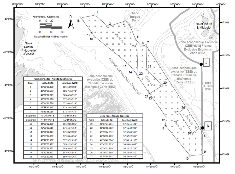
2 (1) The area of the sea depicted in the schedule that is bounded by the following lines is designated as the Laurentian Channel Marine Protected Area:
- (a) a series of rhumb lines drawn from points 1 to 8;
- (b) a geodesic line drawn from point 8 to point 9; and
- (c) a series of rhumb lines drawn from points 9 to 18 and then back to point 1.
Seabed, subsoil and water column
(2) The Marine Protected Area consists of the seabed, the subsoil to a depth of five metres and the water column above the seabed.
Management Zones
Description
3 The Marine Protected Area consists of the following management zones, each of which is depicted in the schedule:
- (a) Zone 1a, which is bounded by a series of rhumb lines drawn from point 6 to point 7, then to points 19 to 23 and then back to point 6;
- (b) Zone 1b, which is bounded by a series of rhumb lines drawn from points 24 to 27 and then back to point 24;
- (c) Zone 2a, which is bounded by a series of rhumb lines drawn from points 1 to 6, then to point 23, then to point 22, then to points 14 to 18 and then back to point 1; and
- (d) Zone 2b, which is bounded by
- (i) a series of rhumb lines drawn from point 7 to point 24, then to point 27, then to point 26, then to point 25 and then to point 8,
- (ii) a geodesic line drawn from point 8 to point 9, and
- (iii) a series of rhumb lines drawn from points 9 to 13, then to point 21, then to point 20, then to point 19 and then back to point 7.
Prohibited Activities
Prohibition
4 It is prohibited to carry out any activity in the Marine Protected Area that disturbs, damages, destroys or removes from the Marine Protected Area any living marine organism or any part of its habitat or is likely to do so.
Exceptions
Permitted activities
5 Despite section 4, the following activities may be carried out in the Marine Protected Area:
- (a) the navigation of vessels provided that there is no anchoring in Zone 1a or 1b;
- (b) fishing, other than commercial fishing, that is authorized under the Aboriginal Communal Fishing Licences Regulations;
- (c) the laying, maintenance and repair of cables in Zones 2a and 2b, provided that it is not likely to destroy the habitat of any living marine organism in the Marine Protected Area;
- (d) any activity that is carried out for the purpose of public safety, national defence, national security, law enforcement or responding to an emergency; and
- (e) any activity that is part of an activity plan that has been approved by the Minister.
Activity Plan
Submission to Minister
6 (1) Any person may submit to the Minister an activity plan for the carrying out of scientific research or monitoring or educational activities in the Marine Protected Area.
Content of plan
(2) The activity plan must contain
- (a) the person’s name, address, telephone number and email address;
- (b) if the activity plan is submitted by an institution or organization, the name of the individual who will be responsible for the proposed activity and their title, address, telephone number and email address;
- (c) the name of each vessel that the person proposes to use to carry out the activity, its state of registration and registration number, its radio call sign and the name, address, telephone number and email address of its owner, master and any operator;
- (d) a detailed description of the proposed activity and its purpose, the methods or techniques that are to be used to carry out the activity and the data to be collected;
- (e) the geographical coordinates of the site of the proposed activity and a map that shows the location of the activity within the boundaries of the Marine Protected Area;
- (f) the proposed dates and alternative dates on which the activity is to be carried out;
- (g) a list of the equipment that is to be used, the means by which it will be deployed and retrieved and the methods by which it is to be anchored or moored;
- (h) a list of the type and quantity of samples that are to be collected;
- (i) a list of any substances that may be deposited during the proposed activity in the Marine Protected Area — other than substances that are authorized under the Canada Shipping Act, 2001 to be deposited in the navigation of a vessel — and the quantity and concentration of each substance;
- (j) a description of the adverse environmental effects that are likely to result from carrying out the proposed activity and of any measures that are to be taken to monitor, avoid, minimize or mitigate those effects;
- (k) a description of any scientific research or monitoring activity or educational activity that the person has carried out or anticipates carrying out in the Marine Protected Area; and
(l) a general description of any study, report or other work that is anticipated to result from the proposed activity and its anticipated date of completion.
Approval of activity plan
7 (1) The Minister must approve an activity plan if
- (a) the scientific research or monitoring activities set out in the plan are not likely to destroy the habitat of any living marine organism in the Marine Protected Area and
- (i) will serve to increase knowledge of the habitat of any living marine organism or the biodiversity or the ecosystem structure and function of the Marine Protected Area, or
- (ii) will serve to assist in the management of the Marine Protected Area; and
- (b) the educational activities set out in the plan
- (i) are not likely to damage, destroy or remove from the Marine Protected Area any living marine organism or any part of its habitat, and
- (ii) will serve to increase public awareness of the Marine Protected Area.
Approval prohibited
(2) Despite subsection (1), the Minister must not approve an activity plan if
- (a) any substance that may be deposited during the proposed activity is a deleterious substance as defined in subsection 34(1) of the Fisheries Act, unless the deposit of the substance is authorized under subsection 36(4) of that Act; or
- (b) the cumulative environmental effects of the proposed activity, in combination with any other past and current activities carried out in the Marine Protected Area, are such that the activity is likely to destroy the habitat of any living marine organism in the Marine Protected Area or adversely impact the biodiversity or the ecosystem structure and function of the Marine Protected Area.
Timeline for approval
(3) The Minister’s decision in respect of an activity plan must be made within
- (a) 60 days after the day on which the plan is received; or
- (b) if amendments to the plan are made, 60 days after the day on which the amended plan is received.
Post-activity report
8 (1) If the Minister approves an activity plan, the person who submitted it must provide the Minister with a post-activity report within 90 days after the last day of the activity. The report must contain
- (a) the data collected during the activity;
- (b) the type and quantity of any sample that was collected, the date of collection and the geographic coordinates of the sampling site;
- (c) an evaluation of the effectiveness of any measures taken to monitor, avoid, minimize or mitigate the adverse environmental effects of the activity; and
- (d) a description of any event that occurred during the activity and that was not anticipated in the activity plan, if the event could result in the disturbance, damage, destruction or removal from the Marine Protected Area of any living marine organism or any part of its habitat.
Studies, reports or other works
(2) The person must also provide the Minister with a copy of any study, report or other work that results from the activity and is related to the conservation and protection of the Marine Protected Area. The study, report or other work must be provided within 90 days after the day on which it is completed.
Coming into Force
Registration
9 These Regulations come into force on the day on which they are registered.
SCHEDULE
(Subsections 1(2) and (3), subsection 2(1) and section 3)
Laurentian Channel Marine Protected Area
REGULATORY IMPACT ANALYSIS STATEMENT
(This statement is not part of the Regulations.)
Executive summary
Issues: The Government of Canada has committed to increase the proportion of Canada’s marine and coastal areas that are protected to 10% by 2020. As part of this commitment, the Laurentian Channel Marine Protected Area Regulations (the Regulations) protect an additional 0.2% of Canada’s oceans located off the southwest coast of Newfoundland. A scientific risk assessment has shown that some ongoing and potential future activities, such as commercial fisheries and the installation of submarine cables in some areas, pose risks to the valuable ecosystem features of the areas. The Regulations help to conserve the area’s biodiversity through the protection of key species and habitats, ecosystem structure and function from human activities that pose a risk.
Description: The Regulations made under subsection 35(3) of the Oceans Act designate the specified portion of the Laurentian Channel as a Marine Protected Area (MPA) covering an area of 11 619 km2. The Regulations prohibit any activity that disturbs, damages, destroys or removes a living marine organism or any part of its habitat in the Laurentian Channel MPA. This includes a prohibition on recreational and commercial fishing, oil and gas development and seismic surveys throughout the MPA. The Regulations allow certain exceptions to the prohibitions for specified activities, if they are compatible with the conservation objectives of the MPA.
The Regulations establish two different management zones within the MPA, each of which is comprised of two spatially distinct areas and provides varying levels of protection, offering the most stringent protection to the areas that need it most. This design prohibits certain human activities, such as submarine cable installation and anchoring within a core protection zone where the ecosystem features and functions of the area are susceptible to their impacts. However, those human activities are allowed within the adaptive management zone because their impacts do not significantly impact the conservation objectives.
Cost-benefit statement: The Laurentian Channel MPA is beneficial for Canadians because of the potential for important long-term ecological benefits gained through the conservation and protection of unique and productive ecosystems. The establishment of this MPA is anticipated to promote the replenishment of depleted stocks within its boundaries and potential spillover to surrounding areas.
The prohibition on recreational and commercial fishing is not anticipated to result in significant costs to Canadian businesses. The average value of fisheries occurring inside the MPA represents less than 0.5% of the annual average landed value of approximately $52 million in the larger fish management area in which the MPA is located.
The present value of potential cost impact on fishing and seafood processing industries is estimated to be approximately $412,000 (discounted at 7%) over the 30-year analysis period. However, these costs are not anticipated to significantly affect the industries’ ability to function and generate revenue, as it is possible that these fisheries could occur outside the restricted area of the MPA.
The prohibition on oil and gas activities is not anticipated to result in any incremental costs to the oil and gas industry. According to a Natural Resources Canada analysis of the energy resources in the area, factoring in current gas prices and initial investment costs, the return on investment for a natural gas project is considered marginal. In addition, due to the relatively low resource potential of conventional oil, an oil extraction project is not considered economically viable. There are currently three project proposals for seismic activities that are targeted for areas within and around the MPA; however, there are no exploratory licences or active wells in the area. No significant new restrictions are proposed with respect to marine navigation (i.e. changes to shipping lanes) beyond a prohibition on anchoring in Zones 1a and 1b, as a consequence incremental cost impacts are not anticipated.
The estimated total annual ecological and compliance monitoring, enforcement and management costs to the federal government for the protection of the MPA are estimated to be approximately less than $325,000 (nominal value) per year. This represents a total cost of $4.3 million in present value terms over a 30-year period (discounted at 7%). No additional resources would be sought and would be funded through existing funding envelopes.
“One-for-One” Rule and small business lens: The “One-for-One” Rule does not apply, as these Regulations do not impose new administrative burden costs on business. The small business lens does not apply, as the expected nationwide costs of the Regulations are well below the $1 million annual threshold to trigger the small business lens, and these costs are not disproportionately higher on small business.
Domestic and international coordination and cooperation: The establishment of the Laurentian Channel MPA will contribute directly to Canada’s efforts to implement measures in line with several international agreements, the most prominent of which is the Convention on Biological Diversity (CBD). In 2010, the Conference of the Parties to the CBD established the following target, known as Aichi Target 11: “By 2020, at least 17 per cent of terrestrial and inland water, and 10 per cent of coastal and marine areas, especially areas of particular importance for biodiversity and ecosystem services, are conserved through effectively and equitably managed, ecologically representative and well-connected systems of protected areas and other effective area-based conservation measures, and integrated into the wider landscapes and seascapes.” By designating Canada’s largest MPA under the Oceans Act, the Regulations will ensure the long-term conservation of an ecologically and biologically important area and contribute to achievement of the Aichi Target 11.
Background
The Laurentian Channel is a deep submarine valley over 1 200 km long, which extends from where the St. Lawrence Estuary and Saguenay River meet to the edge of the continental shelf off Newfoundland. A portion of this area was identified as an Ecologically and Biologically Significant Area (EBSA) in 2007 and selected as an Area of Interest (AOI) in 2010 by the Minister of Fisheries and Oceans Canada for consideration as a Marine Protected Area (MPA).
The Laurentian Channel MPA is an ecologically important area, providing critical habitat for a variety of marine species, some of which are fished commercially. More specifically, Black Dogfish and young and juvenile Smooth Skate are present in high numbers throughout the area. Porbeagle sharks and basking sharks move into the area in the spring and reside within the MPA throughout the summer. One of only two known Porbeagle mating grounds occurs within the boundaries. Two species at risk, the Northern Wolffish and the Leatherback Sea Turtle, have been found in the area. In addition, at least 20 species of whales and dolphins have been observed in the area, as it is a critical feeding area and migration route into and out of the Gulf of St. Lawrence.
The Laurentian Channel contains significant coral and sea pen populations, representing sensitive benthic habitats. Corals and sea pens are important to the ecosystem and depend on the integrity of the sands and muds in the area for their survival. Of the variety of coral species found in the area, sea pens have been recorded in the greatest numbers and diversity, with the Laurentian Channel being described as having the highest sea pen concentrations within the entire Newfoundland and Labrador Shelves Bioregion.
Human activities and related impacts
A science-based risk assessment completed in 2012 determined that some ongoing (fishing, vessel traffic) and potential activities (oil and gas exploration and development, submarine cable installation, anchoring) in the Laurentian Channel MPA were incompatible, to varying degrees, with the conservation objectives for this area.
This area is also a known migration route for various species of fish and pinnipeds. Many of these vulnerable species are present in, or frequent, the Laurentian Channel in ways that necessitate habitat protection due to the particular ecological and geographic features of the area. These animals are vulnerable to activities currently occurring in the area, and in particular to fishing equipment and methods, marine traffic, and other forms of human related contact as they can cause harm to these species and their habitat.
The area within the MPA is known to have been used in the past by commercial fishermen, shipping vessels, and Indigenous peoples. At present, traditional use within the MPA by Indigenous peoples is limited. The Miawpukek First Nation is the only Indigenous group with a licence that provides for food, social and ceremonial (FSC) fishing in the south coast of Newfoundland. The Miawpukek First Nation, however, does not fish within the MPA.
Commercial fish resources in the area have included Atlantic Cod, Redfish, Monkfish, Snow Crab and Atlantic Halibut, and are harvested in accordance with the Fisheries Act, the Coastal Fisheries Protection Act and their regulations. Despite existing legislation, commercial and non-commercial species have seen their populations continually decline in the area. Additional protections are required to also conserve non-commercial species and help ensure future commercial opportunities in the region.
The results of the risk assessment have shown that commercial fishing activities are associated with the greatest risk of harm to the conservation objectives and to the overall goal of biodiversity conservation in the MPA. While fishing activity within the boundaries of the MPA has been low in recent years, commercial fishing activity has resulted in targeted fish stock removal and bycatch, as well as habitat damage. Several conservation objective species are also depleted or at risk, and even limited impacts by commercial fishing activity can have severe consequences for these vulnerable populations. For example, on average, 82% of Smooth Skate caught as bycatch in the Newfoundland and Labrador (NL) region is caught in the Laurentian Channel. Trawling has the potential to impact corals, such as sea pens, through bottom contact, as well as Black Dogfish, Smooth Skate, and Northern Wolffish through incidental catch. Longlines and gillnets have the potential to catch incidental species, and entangle sharks, marine mammals and Leatherback Sea Turtles. Pot gears have been identified as being a significant threat to marine mammals and Leatherback Sea Turtles.
The Gulf of St. Lawrence and the St. Lawrence Seaway, as well as the main shipping lanes between Newfoundland and the Maritime provinces, pass through the MPA. This passageway includes merchant, cruise, and fishing traffic. Vessel traffic poses a moderate risk of harm to Leatherback Sea Turtles, another species at risk. However, there are no recorded incidences of collisions with boats in Atlantic Canada. Shipping poses a risk to corals (sea pens) to the extent that anchoring can damage and destroy these bottom-dwelling animals. It should be noted that between 4 800 and 12 299 vessels including merchant, cruise, and fishing vessels transit through the MPA in an average year with goods destined for places across North America. In light of an incomplete understanding of Leatherback Sea Turtle distribution patterns at this time, it has not been possible to identify conservation measures for marine vessels in transit that would be effective and justifiable given the potential impacts to the Canadian economy. Other threats to the Leatherback Sea Turtle while at sea include entanglement in fishing gear, marine pollution, and acoustic disturbances.
There is currently no oil production in the MPA, and the only exploration licence for drilling expired in 2014. Seismic and other geophysical surveys have and might still occur in the area. Oil and gas activities (with the exception of surveys) can cause permanent harm to coral and sea pens and were therefore determined to be incompatible with conservation efforts for these species. The area has low wave and tidal energy potential and there is a low level of interest for developing these industries from energy development industries.
Submarine cable installation has historically occurred in the area inside the MPA, though most are inactive. Once cables are installed, their use causes no significant harm to the marine ecosystem, and may even be used as habitat or attachment sites for certain organisms. A typical cable installation may involve two or more corridors, each with a footprint of less than 5 m in width. Even though the installation of submarine cables poses a low risk due to their small footprint, any excavation or impact to the sea floor can result in direct mortality of corals as a result of breaking, crushing and burying. Therefore, these activities must be prevented from occurring in areas where sensitive sea pens are concentrated.
Issues
The Laurentian Channel MPA is located off the southwest coast of Newfoundland and lies within the Newfoundland and Labrador Shelves Bioregion, and within North Atlantic Fisheries Organization (NAFO) regulatory area 3P (3Ps and 3Pn). A science-based risk assessment has demonstrated that certain current and potential future activities pose a high risk to many of the conservation priorities for the MPA. Current fishing pressure does not align with a protection or recovery conservation objective. The long-term prohibition of current and potential future fishing activity from this area is needed to alleviate a leading threat to the conservation objectives of the MPA, including endangered species such as the Leatherback Sea Turtle. Potential future activities such as oil and gas exploration and development, which pose a risk to key species and their habitats, also need to be prohibited to ensure alignment with the conservation objectives and overall goal to conserve biodiversity.
Although current legislation helps regulate activities that could affect the features and functions of the Laurentian Channel area, there is no overarching management plan or framework in place to limit or mitigate the impacts of existing or emerging human activities that pose a risk to the established conservation objectives. Unanticipated pressures in other geographic areas or environmental conditions could shift high-risk fishing to the area in the future. Therefore, a more cohesive and predictable regulatory framework in the form of an MPA made through regulations under the Oceans Act is considered necessary to focus efforts on the long-term conservation and protection of the area’s important ecological and biological features. This will be achieved not only through the prohibition of activities in areas where they pose the greatest risk of harm, but also through the implementation of a management plan that will guide scientific research and other authorized activities in the area.
Under the United Nations Convention on the Law of the Sea, Canada’s authority to regulate international navigation rights within Canada’s exclusive economic zone is limited. Nevertheless, based on experience with other MPAs, efforts will be made to enhance stewardship and awareness of the area within the shipping community (e.g. Notices to Mariners).
Objectives
The primary objective of the Laurentian Channel MPA is to conserve biodiversity through the protection of key species and their habitats, ecosystem structure and function, and through scientific research. The most effective way to preserve biodiversity and ensure the survival of species is through long-term habitat protection. The MPA Regulations foster biodiversity conservation in the Laurentian Channel through the reduction of risk and harm posed by human activities.
Supporting the overarching goal and recognizing the important ecological features of the Laurentian Channel, the following conservation objectives were developed for the MPA:
- 1. Protect corals, particularly significant concentrations of sea pens, from harm due to human activities (e.g. fishing, oil and gas exploratory drilling, submarine cable installation and anchoring) in the Laurentian Channel MPA.
- 2. Protect Black Dogfish from human induced mortality (e.g. bycatch in the commercial fishery) in the Laurentian Channel MPA.
- 3. Protect Smooth Skate from human induced mortality (e.g. bycatch in the commercial fishery) in the Laurentian Channel MPA.
- 4. Protect Porbeagle sharks from human induced mortality (e.g. bycatch in the commercial fishery, seismic activities) in the Laurentian Channel MPA.
- 5. Promote the survival and recovery of Northern Wolffish by minimizing risk of harm from human activities (e.g. bycatch in the commercial fishery) in the Laurentian Channel MPA.
- 6. Promote the survival and recovery of Leatherback Sea Turtles by minimizing risk of harm from human activities (e.g. entanglement in commercial fishing gear, seismic activities) in the Laurentian Channel MPA.
Description
The Regulations are made pursuant to subsection 35(3) of the Oceans Act to establish the Laurentian Channel MPA. The MPA covers an area of 11 619 km2. The MPA includes the water column, seabed, and subsoil to a depth of 5 m, which is considered the depth of the active biological layer necessary to support the conservation objectives for the MPA.
Prohibitions
The Regulations prohibit any activity within the designated boundaries that disturbs, damages, destroys or removes any living marine organism or any part of its habitat, or that is likely to do so. This includes the prohibition of all commercial or recreational fishing, oil and gas activities, and seismic surveys.
MPA boundaries and management zones
The Regulations designate the Laurentian Channel MPA boundaries and its internal management zones (Figure 1). Within the designated management zones, specific activities are allowed (as exceptions to the prohibition), insofar as they do not compromise the overall conservation objectives of the MPA. The zoning provides varying levels of protection within the MPA, offering the most stringent protection to the areas that need it most.
Core protection zone (CPZ)
The CPZ is comprised of two spatially distinct areas (Zones 1a and 1b) that are strict protection zones designed to provide the highest level of protection to areas containing high concentrations of coral and sea pens. The only activities that are allowed within the CPZ are activities for public safety and national security; Aboriginal food, social and ceremonial fisheries; and marine navigation (excluding anchoring). Other specified activities would be allowed if they are approved by the Minister as part of an activity plan (e.g. scientific monitoring). Zone 1a is approximately 1 495 km2 and Zone 1b is approximately 614 km2. The CPZ ensures areas of high concentrations of corals/sea pens, which are fixed to the sea floor and greatly affected by activities that impact the sea floor like trawling, oil and gas activity, anchoring, and submarine cable installation, are protected over the long term.
Adaptive management zone (AMZ)
Zones 2a and 2b in the AMZ allow varying levels of use and accommodate those activities which are compatible with the conservation objectives of the MPA as described above. Given that species of concern may be found within the AMZ, all commercial fishing is prohibited as this activity poses a high risk to these particular species. Oil and gas activities are also prohibited within the AMZ, including seismic surveys. Marine navigation including anchoring is allowed in these zones as it does not present a particular threat to the marine life in this portion of the MPA. Submarine cable installation is allowed within the AMZ as long as they are not likely to destroy marine habitat. Zone 2a is approximately 4 034 km2 and Zone 2b is approximately 5 476 km2.
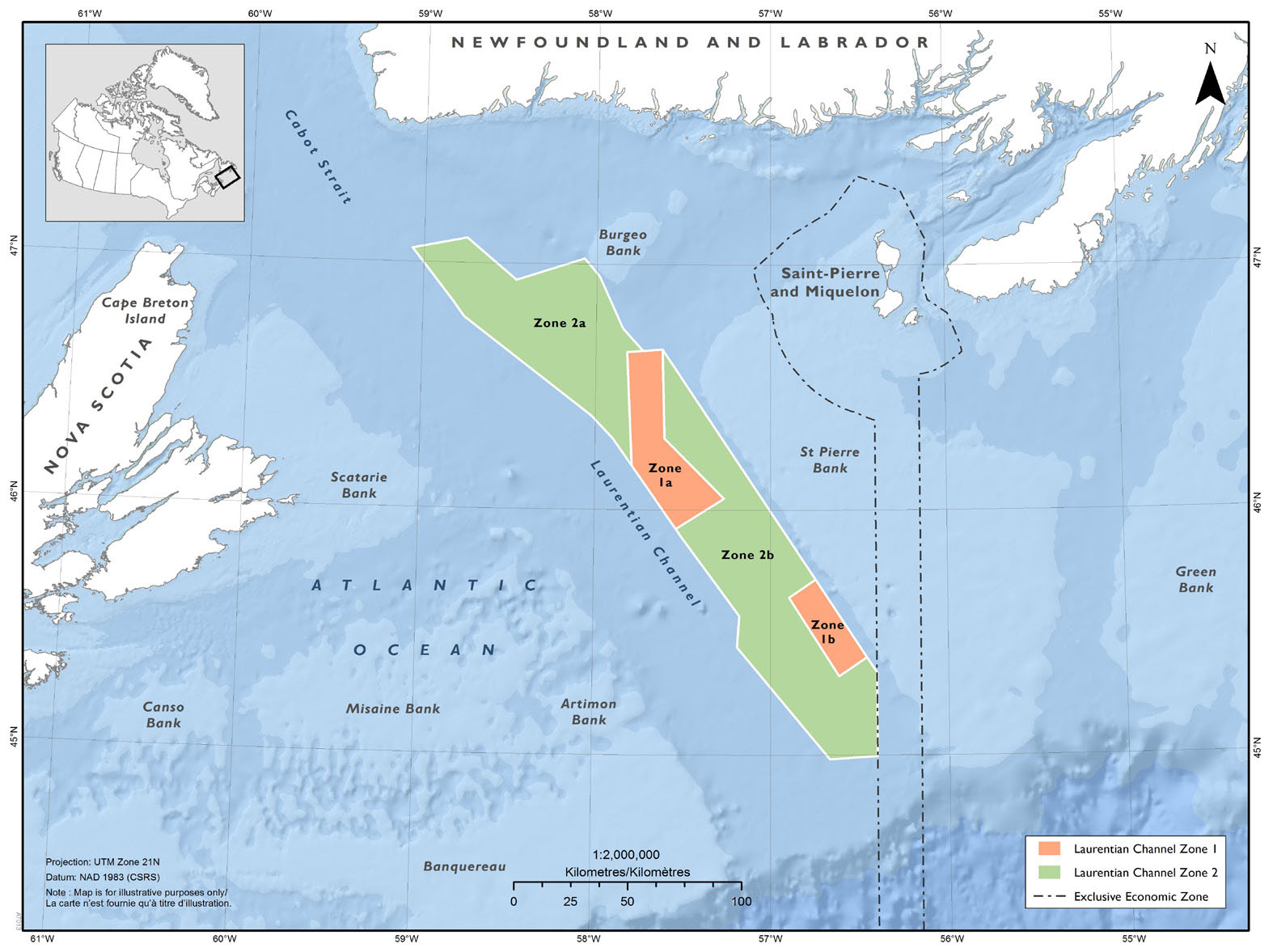
Figure 1: Map showing an illustration of the Laurentian Channel Marine Protected Area, its boundaries and its management zones
Activities allowed within the MPA by the Regulations
Only the following activities are allowed in the MPA:
- Fishing: Aboriginal food, social and ceremonial fisheries would, subject to relevant legislation, continue to be allowed throughout the MPA. All other commercial and recreational fishing is prohibited.
- Marine navigation: All navigation is allowed within the MPA, with the exception of anchoring, which is prohibited in Zones 1a and 1b to protect the sensitive benthic coral and sea pen concentrations.
- Cables: Installation, repair and maintenance of submarine cables continue to be allowed in Zones 2a and 2b so long as they are not likely to destroy marine habitat. These activities are prohibited in Zones 1a and 1b due to the level of risk associated with their impact to coral and sea pen concentrations.
Scientific research, monitoring, and education: Scientific research, scientific monitoring, and educational activities are permitted throughout the MPA subject to the Minister’s approval of an activity plan. Applicants are required to submit an activity plan containing the information listed in section 6 of the Regulations for approval by the Minister. Activity plan information is used to help better evaluate the potential impacts of the proposed activity on the conservation objectives of the MPA and serve as the basis for decisions on whether or not to approve the activity.
Safety and security: Activities related to public safety, national defence, national security, law enforcement, or in response to an emergency (including environmental emergencies) are allowed throughout the MPA.
Regulatory and non-regulatory options considered
A risk assessment has shown that some ongoing and potential future activities pose a risk to conservation objectives. Existing regulatory tools, applied independently, do not adequately mitigate those risks.
Certain marine activities are already regulated under provisions of the Fisheries Act, the Species at Risk Act and other federal legislation, whose purposes differ from that of the Oceans Act. Fisheries and Oceans Canada (DFO) acknowledges that voluntary measures are employed by some sectors to limit impacts to the area’s ecology (e.g. voluntary avoidance of certain areas to limit damage to coral and sponges from bottom contact fishing gear). However, these measures are not enforceable and create inconsistencies within the relevant sectors.
Each MPA is uniquely designed to achieve site-specific conservation objectives while minimizing, to the extent possible, socio-economic impacts on stakeholders. The activities prohibited or allowed in each MPA are determined on a case-by-case basis through a risk assessment of the potential impacts of human activities on the achievement of the respective conservation objectives. As such, the conservation objectives and regulatory approaches for the Laurentian Channel MPA differ from other Oceans Act MPAs. The regulatory framework, including the prohibitions against oil and gas and seismic activities, most fishing, and restrictions on anchoring, has been assessed to ensure alignment with the conservation objectives of the MPA.
Benefits and costs
Benefits
The incremental benefits of the MPA are largely related to conserving and protecting unique, sensitive and productive ecosystems. MPAs generally have been demonstrated to function as both a refuge for and a source of commercially and socially valuable marine species. The establishment of an MPA mitigates direct and indirect risks to migratory populations and protects fish, marine mammals, invertebrates, corals, and benthic fauna during critical life cycle stages. Protection of multiple habitat elements for fish, marine mammals, invertebrates, corals, and benthic fauna, which are critical to certain key life cycle stages (including mating, spawning, nursing, and feeding), contribute to general health of the marine area. While difficult to quantify due to the unique conditions of every ecosystem, international literature suggests that there is potential for increases in the abundance, diversity, and productivity of marine organisms through the designation of MPAs. In the context of the Laurentian Channel MPA, important components of the marine ecosystem such as Smooth Skate, Northern Wolffish, Black Dogfish, Porbeagle Shark, Leatherback Sea Turtle, and sensitive benthic habitats represented by corals and sea pens, are protected through the management of human activities within its boundaries.
Additionally, the MPA is anticipated to provide social and cultural benefits to the people residing in the region. Subsistence and ceremonial fishing contributes to preserving traditional Indigenous lifestyles in the region and would continue to do so while serving as an important source of food. As fish stocks improve over time, opportunities to maintain traditional uses as well as commercial harvests will be enhanced under the regulatory requirements.
Furthermore, the MPA designation is expected to contribute to non-consumptive use benefits (such as tourism) that stem from the value held by Canadians for the continued existence and protection of unique habitat and species. As well, important marine features, and the value society places on MPAs and their current and future contribution to a strong and healthy ecosystem will be augmented.
The MPA designation promotes focused scientific research in an area protected from the impacts of human activities that pose a risk. Therefore, the MPA provides an opportunity for controlled scientific research within Canada, not only for the federal government, but also for academia and research institutions.
Costs
Government
Costs to the Government of Canada for the administration and management of an MPA include costs associated with activity plan assessments and approvals, scientific research, information management, ecosystem monitoring, surveillance and enforcement, emergency response, as well as public consultation, education and stewardship programs. The estimated total annual ecological and compliance monitoring, enforcement and management costs of the MPA would be less than $325,000 (nominal value) per year. This represents a total maximum cost of $4.3 million in present value terms over a 30-year period (discounted at 7%). These costs are associated with a range of activities including, but not limited to, vessel costs, technical equipment, an aerial surveillance program, and a coordinated inter-agency approach to compliance and enforcement that reflects the site’s remote offshore location.
Commercial fishing and seafood processing sector
Costs associated with fisheries prohibitions in the MPA can be categorized as forgone revenue, footnote 1 increased variable fishing costs or compliance costs. The MPA represents a geographic subset of larger fishing areas where fishing enterprises or fleets have defined fishing privileges with quota allocations. In addition, fishing activity within the boundaries of the MPA has been low in recent years. The average annual value of fisheries occurring inside the MPA represents less than 0.5% of the total value of the larger fish management area within which the MPA is located.
Prohibition of fishing activity throughout the MPA is not expected to result in any significant loss of landings because it is anticipated that the fishing enterprises could make up for any loss in landings in the adjacent areas where they will continue to retain fishing privileges, subject to the Fisheries Act. Furthermore, international literature suggests that it is possible that fishing in the adjacent areas will actually be enhanced in the longer term due to the presence of the MPA. The degree to which such offsetting activities would occur is not known at this time, but is expected to result in a low impact on fishing activities. The maximum possible losses are estimated below, assuming zero redirection of effort.
Based on the most recent average catch data for the period 2015 to 2017, the maximum nominal value of the annual loss of landed revenue from commercial fisheries as a result of the Regulations is estimated to be $93,900 with an associated loss of profit of about $17,500 per year. The Regulations are anticipated to primarily impact annual landed values for the redfish, sea cucumber and sea scallop commercial fisheries. The total present value of the incremental costs (i.e. loss of profits) to the commercial harvesting industry is estimated at approximately $234,000 (over a 30-year period discounted at 7%). The incremental costs of the Regulations could potentially impact 21 enterprises in the affected fisheries to varying degrees that had landings from the MPA area during the 2015–2017 period. Although the level of impact may vary by enterprise, none of the enterprises have a high degree of dependency on the MPA area.
Fish harvesters are required to comply with the MPA regulations, as they currently do with respect to Fisheries Act regulations and management measures. Vessels that fish near this offshore area are generally equipped with Global Positioning System technology to support efficient fishing operations and to respect existing fishing boundary constraints. Therefore, additional compliance costs as a result of the establishment of this MPA are expected to be negligible.
The maximum anticipated loss of landings from fisheries that are prohibited from the MPA is estimated to result in an additional reduction of $132,500 (nominal value) in revenue per year for seafood processors. The loss in profits associated with these reductions in processing activity is estimated to be about $13,250 (nominal value) per year. The total present value of the incremental costs (i.e. loss of profits) to the seafood processing industry is estimated at approximately $177,600 (over a 30-year period discounted at 7%).
Oil and gas exploration and development
The Regulations prohibit all oil and gas activities throughout the MPA. According to an analysis of the energy resources and minerals within the Laurentian Channel MPA conducted by Natural Resources Canada (NRCan), the MPA is located in an area of substantial conventional natural gas and unconventional gas hydrate resource, with lesser oil potential. The report also noted that parts of two major sedimentary basins (Sydney Basin and Scotian Orpheus Graben) occur within the MPA, both of which have conventional oil and gas potential. Most of the MPA has high to moderate potential. However, NRCan analysis also indicates that although gas hydrate volumes are considered substantial; the current technological and economic factors (such as gas prices and initial capital and operating costs) limit the potential for extraction and development of these resources. Furthermore, due to the relatively low resource potential of conventional oil, an oil project is not considered economically viable.
This is consistent with federal and DFO guidance for conducting economic analysis which requires evidence of intent to undertake new economic activities (e.g. licences or permits) for incremental impacts to be assessed.
According to the Canada-Newfoundland and Labrador Offshore Petroleum Board (C-NLOPB) project based assessment list, there are currently three project proposals for seismic activities that are targeted for areas within and around the MPA; however there are no exploratory licences or active wells in the area. In view of the above, no incremental costs are anticipated to the oil and gas industry as a result of the prohibition on all oil and gas activities within the MPA. This is supported by NRCan’s assessment of the potential oil and gas resource within the area which indicates low expected returns from any potential oil or natural gas project in the MPA.
“One-for-One” Rule
The “One-for-One” Rule footnote 2 does not apply as there is no change in administrative costs to business. No commercial enterprises are carrying out the activities subject to the requirement to prepare and submit an activity plan for scientific and educational activities in the MPA.
Small business lens
The small business lens footnote 3 does not apply as there are no significant increased costs to small businesses as a result of these Regulations. The administrative and compliance costs associated with the MPA are expected to be well below the $1 million threshold.
Consultation
The AOI selection and subsequent MPA development process has been transparent and participatory, including extensive consultations initiated in 2008, so that any potential issues could be addressed early on. Through Advisory Committee and bilateral meetings, DFO has completed over 130 consultations with more than 30 stakeholder groups throughout the MPA designation process, including AOI selection, ecological and socio-economic assessments, establishment of conservation objectives, boundary delineation, and management scenarios. By selecting this portion of the Laurentian Channel as the AOI, DFO has maintained the site’s significant conservation value while minimizing potential impacts on resource users. DFO negotiated spatial boundaries and regulatory proposals for the MPA that reflect and balance economic concerns with biological conservation objectives.
Following the publication of the regulatory proposal in the Canada Gazette, Part I (CGI), footnote 4 the Regulations were further revised. In particular, while the published proposal allowed for oil and gas development within the AMZ as well as for seismic surveying to occur within certain periods, the final Regulations prohibit both of these activities throughout the MPA. These changes respond to recent scientific information and input received from the consultations during prepublication. More details concerning the modifications can be found in the section below entitled Canada Gazette, Part I, summary.
AOI selection process
DFO consulted with 10 key stakeholder groups during spring and summer 2008 to narrow the original list of 11 Ecologically and Biologically Significant Areas (EBSAs) identified by DFO to a shortlist of 5 candidate AOI sites. Formal consultations on those five EBSAs were conducted between December 2008 and April 2009 with industry, other federal departments, provincial government, Indigenous groups, environmental organizations, and other stakeholders. In addition to comments that were recorded during these consultations, participants were also encouraged to provide written submissions. Formal consultation sessions were conducted with 22 groups in total. On World Oceans Day (June 8, 2010) the Laurentian Channel was announced as a new AOI for potential designation as an MPA under the Oceans Act.
Laurentian Channel Advisory Committee
The Laurentian Channel Advisory Committee was created in 2011 to actively engage stakeholders and other government departments in the development of regulatory measures, plans, and strategies for MPA management and to provide advice to the DFO Minister on these matters. The Committee, chaired by DFO, included representatives of other federal departments, the Government of Newfoundland and Labrador, the Canada–Newfoundland and Labrador Offshore Petroleum Board, Miawpukek First Nation, the fishing industry (inshore and offshore representative organizations), conservation organizations, and academia. Through this Committee, all stakeholders and partners have had, and will continue to have, direct involvement in the MPA development and management processes. In addition, several key stakeholders participated in the DFO Science led Biophysical Regional Assessment Process and preparation of the Social, Economic, and Cultural Overview. The regulatory intent was consulted on with all Committee members before finalizing the regulatory proposal.
MPA design and management proposal
The key elements of the Regulatory framework for this MPA were summarized in a document titled “Management Approach” and distributed to the Advisory Committee and other stakeholders during the summer of 2014. Since that time, more than 30 meetings have been held with stakeholders. To ensure that all interested parties would have access to the latest information available, 26 of those meetings have taken place since April 2016. These meetings focused on the Government’s marine conservation targets, the regional plan to meet those targets and, more specifically, the designation of the Laurentian Channel MPA in 2017. Participants have included Provincial and Federal representatives, Nunatsiavut Government, Miawpukek First Nation, conservation organizations, and industry.
A summary of the feedback received during the MPA development process is provided below.
Commercial fishing sector
Fishery prohibitions
Throughout the consultation process, some members of the fishing industry expressed opposition to the MPA due to concerns about the prohibition that would eliminate existing fisheries within its boundaries. DFO subsequently negotiated spatial boundaries and regulatory proposals for the MPA that reflect and balance economic concerns with biological conservation objectives. Furthermore, it was demonstrated that the Regulations only create a displacement of effort, not a reduction in catch nor an increase in costs. It is anticipated that affected fishing enterprises will make up for the loss of landings due to the MPA in the adjacent areas where they will continue to have fishing privileges. The prohibition of fishing activity within the MPA is not expected to result any significant loss of landings footnote 5 and the fishing enterprise are not anticipated to experience any incremental costs. The Fish, Food and Allied Workers Union (FFAW-Unifor) fisheries union expressed concern that the original proposal allowed for oil and gas activities in the AMZ of the MPA, while prohibiting fishing. In particular, they were concerned about the long-term effects of seismic and other oil and gas activities on marine species and commercial fisheries. The framework provided for in the final Regulations is based on the results of the scientific risk assessment, which showed that fishing poses high risks to most of the conservation objectives. Furthermore, in order to better align with the MPA’s conservation objectives, the final Regulations prohibit oil and gas activities and seismic surveying throughout the MPA. DFO also remains committed to working with all stakeholders to develop a management plan that will incorporate new and emerging information.
Adaptive management
Fish harvesters emphasized the need to consider the possible return of historical commercial fisheries to the area. Several questions were related to what would happen in the future if currently depleted stocks rebound within the MPA, and if so, whether fishing would be allowed. As a response, a clear commitment to adaptive management was outlined in the Management Approach document to clarify that “[…] the MPA will undergo a 5 year adaptive management cycle whereby regulatory measures – including boundaries and allowed activities – will be assessed and all new information reviewed.”
Oil and gas sector
Core protection zones (Zones 1a and 1b)
While there are no current plans for oil and gas production in the MPA or adjacent areas, the oil and gas industry noted, in a media statement in June 2017, that there is still interest in exploring the region. Representatives from the oil and gas industry previously raised concerns with respect to limitations on potential future activities as the MPA overlaps with two different sedentary basins. footnote 6 They also expressed concerns that the original size and shape of Zones 1a and 1b would have made a significant portion of the area inaccessible to directional drilling. In the draft published in CGI, an attempt was made to address these concerns via modifications to the boundaries of these zones, while still protecting the significant concentrations of sea pen areas within the MPA to ensure compatibility with the conservation objectives. However, as described in additional detail below, further consideration of the scientific evidence as well as the input received following publication has led to the prohibition of oil and gas activity throughout the MPA.
Seismic activity temporal restriction
Consultations with representatives of the oil and gas industry active in the area suggested that an effective seismic program might be conducted in a three-month window of time. For this reason, the CGI proposal would have allowed for these activities anytime within an eight-month window, in order to accommodate the industry’s needs to operate safely in variable and unpredictable conditions while ensuring that no seismic activity could occur during sensitive periods for the conservation of key species. For example, the initial proposal to restrict seismic activity sought to protect Leatherback Sea Turtles when they are found in the highest concentrations in this area (August and September). As discussed further below, the final Regulations prohibit seismic surveys throughout the MPA during all parts of the year.
Province of Newfoundland and Labrador
The Province of Newfoundland and Labrador has been engaged in the development of the MPA. The most significant issue raised by the Province was the size of the CPZ in the original policy proposal and its potential effects on oil and gas development. As noted above, while the CGI proposal attempted to address these concerns via modifications to the boundaries of these zones, the final Regulations prohibit oil and gas activities throughout the MPA.
Government of France (Saint Pierre and Miquelon)
A French territory in North America is located 25 km southwest of Newfoundland, with an exclusive economic zone adjacent to the MPA. The archipelago of Saint Pierre and Miquelon is composed of eight islands, totalling 242 km2. The Government of France (Saint Pierre and Miquelon) was consulted on the MPA throughout the MPA development process and has not expressed any concerns. The MPA will not cause any reductions in the commercial French fishing quotas or capabilities.
Conservation organizations and academia
Core protection zone
Representatives from this sector disagreed with the possible reduction in size of the CPZ under the original proposal, as they suggested it was based exclusively on possible economic gains in the future. These concerns are fully addressed in the final Regulations, in which oil and gas activities are prohibited in both the CPZ and the wider AMZ.
Oil and gas activity
Representatives of environmental non-governmental organizations (ENGOs) were opposed to the original proposal to allow oil and gas activity inside the MPA.footnote7 However, they expressed support for the MPA designation and agree with the overarching conservation goal. DFO and other stakeholders have engaged ENGO representatives through the Advisory Committee over the four-year period from 2010 to 2014. All parties have agreed that the Oceans Act does not require that MPAs be fully closed to all human activities if these activities do not compromise the conservation objectives of the area.
Indigenous groups
All Indigenous groups and associations with an interest in the area have been consulted during the MPA establishment process including Miawpukek First Nation, Innu Nation, Qalipu First Nation, NunatuKavut Community Council, and the Nunatsiavut Government. No issues of concern regarding the MPA designation, the zoning specifications or the Regulations were raised by Indigenous groups. Most of these groups are located in Labrador and were consulted with respect to the MPA from 2009 to 2013. The Miawpukek First Nation is present on the south coast of Newfoundland and has elected to participate on the Laurentian Channel Advisory Committee, which provides an additional forum for engagement on the designation process.
Canada Gazette, Part I, summary
The proposed Regulations were published in CGI on June 24, 2017, followed by a 30-day public comment period. Stakeholders who had been engaged in the development of the MPA, including federal agencies and provincial governments, Indigenous groups, industry, and non-government organizations, were provided with written notification of publication through email correspondence.
A total of 79 submissions were received and taken into consideration during the 30-day public comment period. Parties who submitted comments included Indigenous groups, provincial government, academics, industry, environmental non-governmental organizations, and members of the public. In addition, five online petitions were generated during the CGI public comment period with a combined total of 72 667 signees; including Avaaz (37 972 signees), Canadian Parks and Wilderness Society [CPAWS] (4 362 signees), Leadnow (14 095 signees), Sea Shepherd Conservation Society (14 228 signees), and the Sierra Club of Canada (2 010 signees). The standard message which was generated for each submission for the different petitions supported the creation of the MPA, but disagreed with allowing oil and gas exploration and extraction.
Only two submissions were in support of the Laurentian Channel MPA Regulations as proposed, which were submitted by the Canadian Association of Petroleum Producers (CAPP) and the Government of NL. All the other submissions support the creation of the MPA and the proposal to prohibit all industrial fishing, but request that oil and gas exploration and development be prohibited within its boundary. Other issues raised include concerns with the removal of areas from the original AOI boundary, requests to include cod, redfish and marine mammals as specific conservation objectives, challenges regarding the consultation process, lack of scientific advice for certain aspects of regulatory intent development, and lack of transparency.
A summary of the comments received during the public comment period, including the Department’s responses, is outlined below:
1. Prohibition of all oil and gas exploration and development activities within the entire MPA
All but two submissions requested that the regulatory proposal be revised to prohibit all activities associated with oil and gas exploration and development, including seismic surveys. The proposal in CGI included an exception from the general prohibition to allow for oil and gas exploration and development within Zones 2a and 2b (the Adaptive Management Zone), and allowed seismic surveys to take place within the entire MPA from December 1 to July 31. The comments made by stakeholders stated that allowing oil and gas activity contradicts the conservation objectives, and allowing seismic surveys any time of the year directly conflicts with the goal of the MPA.
Comments received from the FFAW-Unifor, the Gulf NS Herring Federation and the Save our Seas and Shores Coalition also expressed concerns regarding the impacts of seismic surveys, particularly on Atlantic Cod in NAFO Subdivision 3Ps, as cod are found in spawning and pre-spawning aggregations during times when seismic surveys could occur. They also stated concerns about impacts of seismic activity on commercial fishing activity and on fish species and habitats. The Gulf NS Herring Federation and the Save our Seas and Shores Coalition also expressed concern related to the impact of oil and gas activity on herring, mackerel and lobster.
Those stakeholders in favour of allowing potential oil and gas activities to take place within the MPA (the Government of Newfoundland and the Canadian Association of Petroleum Producers) state that offshore petroleum exploration and development is a vital component of the NL economy and a commercial natural gas field so close to the island of Newfoundland would be advantageous for the Province. The Canadian Association of Petroleum Producers also provided statements as to the lack of evidence for long-term impacts of seismic noise to fish or marine mammals, and long-term impacts from routine operating procedures on invertebrate and fish samples.
Response:
Given a study conducted by Kenchington et al. (2016), based on modelling, that suggests a possible larger sea pen concentration area than previously estimated, and the overwhelmingly negative response from Canadians regarding the regulatory proposal to allow oil and gas exploration and development within the Adaptive Management Zone of the MPA, the final Regulations prohibit oil and gas activities within the entire boundary of the Laurentian Channel MPA. For similar reasons, seismic surveys which were originally proposed to take place from December 1 to July 31 will also be prohibited throughout the MPA.
An underlying goal of the consultation process has been to balance environmental conservation considerations while minimizing potential impacts on resource users, including the oil and gas industry. However, a growing body of scientific evidence paired with expert opinion and input from Canadian citizens, stakeholders and industry has culminated in the decision that oil and gas activities are not compatible with the MPA’s objectives and its overarching goal to protect biodiversity. Removing the exception for oil and gas activity and development demonstrates Canada’s commitment to the protection of the species and habitats which make this area uniquely important.
Stakeholders impacted by the change of regulatory approach (Province of Newfoundland and Labrador, CAPP, C-NLOPB, Miawpukek First Nation) were consulted in October 2017. In separate face-to-face meetings, regional officials with Fisheries and Oceans Canada advised that the Government of Canada, based on comments from the CGI process, would be proposing regulations that prohibit oil and gas activity within the proposed MPA.
The Province of Newfoundland and Labrador, C-NLOPB and CAPP identified a number of issues. In particular, they raised whether this decision is precedent-setting for oil and gas activities in future MPAs; the cumulative impacts of this change on industry; the nature/validity of comments received through the CGI process; the perceived lack of a scientific basis to support the decision; the need to revise the Mineral and Resource Assessment; and the sufficiency of the rationale for significantly revising the regulatory proposal to prohibit oil and gas that had been developed in partnership over several years.
The Miawpukek First Nation agreed with the decision to prohibit oil and gas activities in the MPA, inquired about the rationale for changing the regulatory proposal and requested an overview of the CGI submissions, which was provided. The Miawpukek First Nation also questioned whether this decision would be precedent-setting.
In April 2018, the Minister of Fisheries, Oceans and the Canadian Coast Guard launched a National Advisory Panel on MPA Standards, which delivered its final report on September 26, 2018. In the report, the Panel recommended that the Government “adopt International Union for the Conservation of Nature standards and guidelines for all marine protected areas, therefore prohibiting industrial activities such as oil and gas exploration and exploitation, mining, dumping and bottom trawling.”
In spring 2019, the governments of Canada and Newfoundland and Labrador came to an agreement to prohibit petroleum activities in the Laurentian Channel Marine Protected Area. DFO re-engaged stakeholders impacted by the change in regulatory approach (C-NLOPB, CAPP, Newfoundland and Labrador Oil and Gas Industries Association [NOIA] and Nalcor), who continue to express concerns regarding the comprehensive prohibition on oil and gas activities throughout the MPA. In light of the recommendations of the National Advisory Panel on MPA Standards, new information on larger sea pen concentration area than previously estimated, and in recognition of feedback received during the public comment period, DFO is of the view that these prohibitions are needed to enhance the integrity of the MPA.
2. Allowing oil and gas activity while prohibiting all commercial fishing
The Maritimes Aboriginal Peoples Council (Nova Scotia), the FFAW-Unifor, and members of the Federation of Independent Sea Harvesters of Newfoundland and Labrador (FISH-NL) voiced their concern that commercial fishery prohibitions are being put in place while natural resource exploitation and development is allowed. These stakeholders felt that there was a bias against commercial fishing and that the impacts of oil and gas activities are not scrutinized the same way those of fisheries are.
Response:
A scientific risk assessment determined that commercial fishing activities pose a significant risk of harm to the conservation objectives for the MPA, therefore all commercial fishing activities will be prohibited. The MPA Regulations will only create a displacement of activities from the fishing industry, not a reduction in catch or an increase in costs. It is anticipated that affected fishing enterprises will make up for any loss of landings due to the MPA in the adjacent areas where they also have fishing access.
Spatial boundaries and regulatory measures for the Laurentian Channel MPA as proposed in CGI reflected an attempt to balance economic concerns and biological conservation objectives. However, after careful consideration of new available science and the comments received during CGI, oil and gas activities will also be prohibited in the MPA in order to provide cohesive protection to the species and habitats of the MPA.
The concerns of fishing groups regarding oil and gas activity are addressed in the final Regulations’ prohibition of all oil and gas activity, including seismic surveys, within the entire boundary of the Laurentian Channel MPA.
3. Issues of concern to Indigenous peoples
No comments were received from Indigenous groups in Newfoundland and Labrador; however, one submission from the Maliseet (Wolastoqey) Nation in New Brunswick outlined concerns regarding the wider process by which MPAs are being established in Atlantic Canada, particularly that consultations with First Nations groups are not being completed before consultations with other stakeholders. They also state that DFO should provide adequate time and resources for the Wolastoqey to work within their communities to delineate Indigenous MPAs in advance of any Oceans Act MPA being proposed, including other future proposals in Gulf of St. Lawrence and Scotian Shelf Bioregions. Concerns related to the Laurentian Channel MPA include the allowance of oil and gas activity within the Adaptive Management Zone and the allowance for seismic activity from December 1 to July 31, as they state these activities are incompatible with the conservation objectives. Many concerns relate to effects of seismic surveys on zooplankton, Atlantic salmon, as well as ocean function and productivity and the risk of oil spills. The group is of the opinion that oil and gas activity impacts will be felt in areas far beyond the MPA.
Response:
The development of an Indigenous Protected Area (IPA) concept is gaining momentum in both international and domestic contexts; however, discussions about a Canadian definition or framework are only recently under way. In March 2018, the Indigenous Circle of Experts (ICE) released a report and recommendations that describe the concept of Indigenous Protected Areas in terrestrial, coastal and inland waters. DFO is a member of the ICE and will seek to align its analysis of the potential for IPAs in the marine context with the more terrestrially focused work of the ICE. DFO has also initiated some preliminary analysis on the range of Indigenous participation in current Oceans Act marine protected areas.
The prohibition on all oil and gas activity, including seismic surveys, within the entire MPA will alleviate concerns expressed by the Maliseet (Wolastoqey) Nation regarding the Laurentian Channel MPA, in particular the risk of seismic impacts and risk of oil spills.
4. Changes to the MPA boundary from original AOI
Submissions from several ENGOs, a Memorial University professor, FISH-NL, and the Council of Canadians in Kent County (New Brunswick) all cited concerns regarding the boundary delineation of the MPA from that outlined in the original AOI. Several submissions suggested that areas removed from the original AOI boundary were not vetted by science and were removed for socio-economic or political reasons and may vastly decrease the ability of the MPA to provide conservation benefits. The World Wildlife Fund – Canada (WWF – Canada) specifically stated that changes to the boundary will result in a smaller portion of the biomass of focal species being protected, and removing an area from the slope reduced representation of habitat types, which is important for biodiversity conservation. Some submissions stated that the process behind changes to the boundary was not transparent.
Response:
The Laurentian Channel and Slope Ecologically and Biologically Significant Area (EBSA) was identified by DFO Science in 2007 for the Placentia Bay–Grand Banks Large Ocean Management Area (PBGB LOMA). The Laurentian Channel was announced as an AOI in June 2010. This announcement signalled DFO’s intention to evaluate a part of the ocean in order to decide whether or not it meets the MPA criteria outlined in the Oceans Act. The boundary delineating the AOI was considered a study area and was not intended to represent the eventual MPA boundary. It was clearly communicated to all stakeholders that the Advisory Committee would offer advice to DFO throughout the MPA development and designation process, including the determination of boundary lines.
The boundary delineation was an open and transparent process. Several alterations were made from the original AOI to the proposed MPA boundary based on discussions and negotiations with various stakeholders and industry. The definition of the proposed MPA boundary was based on existing jurisdictional and administrative boundaries; the conservation objectives and the geographic location of the ecologically significant components; socio-economic and socio-cultural information; the need for a spatially continuous boundary to facilitate compliance and enforcement; and input from stakeholders, including the Laurentian Channel AOI Advisory Committee members. For example, modifications were made to ensure administrative issues did not complicate the regulatory proposal, such as the portion of the AOI that overlapped with the France Economic Exclusion Zone, or overlap with the Canada–Nova Scotia offshore area. footnote 8 Certain portions were removed from the original AOI boundary based on economic considerations, but key areas of ecological importance were not compromised. The evolution of boundary delineation and the rationale behind any proposed changes were presented to the Laurentian Channel Advisory Committee on July 29, 2014. Committee members were invited to provide feedback at that time or in a written submission after the meeting concluded.
5. Additional conservation objectives
Comments received from WWF – Canada requested that DFO apply the precautionary approach to include Atlantic Cod, Atlantic and Deepwater Redfish, and all marine mammals as specific conservation objectives within the MPA proposal. They also requested that species at risk that frequent the area, including the North Atlantic Right Whale, be considered priorities for conservation. The Ecology Action Centre also expressed the opinion that the conservation objectives should be revisited and that reconsideration should be given to the importance of the Laurentian Channel to cod and redfish recovery. The Council of Canadians in Kent County (New Brunswick) stated that all species that were identified in the early AOI overview should be included as conservation objectives, with cod and redfish given further conservation support.
Response:
A Canadian Science Advisory Secretariat (CSAS) Regional Advisory Process was held in November 2010 for the Biophysical Overview to review and assemble available information on various physical and biological components of the study area and to provide scientifically based conclusions regarding the available baseline information related to ecological conditions, species and habitats, as well as to highlight uncertainties and knowledge gaps. The conservation objectives for the Laurentian Channel MPA were developed in consultation with DFO Science and the AOI Stakeholder Advisory Committee, and are based primarily on the Biophysical Overview. A CSAS meeting to develop monitoring protocols, indicators, and strategies for the MPA took place in June 2014. Comments from this process resulted in refined wording of some conservation objectives in order to ensure effective management of the MPA.
For an Oceans Act MPA, conservation objectives serve a regulatory and operational purpose, supporting pragmatic decision-making in the design of the MPA Regulations and the management of the MPA. They are key to the design and establishment of the MPA and they provide the standard against which to measure success when evaluating MPAs in Canada. They are measured through the monitoring of associated indicators which signal whether MPA Regulations and management actions are effective or whether adaptive management is required.
Lack of knowledge and data deficiencies identified in the Biophysical Overview translated into research objectives for the MPA. Several important components of the Laurentian Channel ecosystem merit protection, yet data is too sparse to create specific conservation objectives. Research objectives have therefore been developed as a way to promote focused scientific interest and acquire baseline data which will lead to better understanding and an increased ability to protect priority species.
While not all the species present in the area were identified as conservation objectives, the goal of the MPA is to conserve biodiversity and its designation will provide benefits to a vast array of species. Biological and physical components of the Laurentian Channel ecosystem will be conserved and protected, including fish, marine mammals, invertebrates, corals, and benthic infauna. The MPA will help to protect habitats that are critical to certain key life cycle stages for various species, including spawning grounds, mating areas, nursery grounds and important feeding areas. Designation will serve to mitigate direct and indirect risks to the resident and migratory populations utilizing the area in a comprehensive, long-term manner. Limiting the exposure and impacts from human activities within the entire MPA will allow the area to return to a natural state, creating refuge where species can reproduce at increased rates, and provide significant opportunities for recovery and conservation.
6. Removal of core protection zone (Zones 1a and 1b)
Comments from academia and WWF – Canada both suggested removing all zoning from the MPA proposal in conjunction with prohibiting all oil and gas activities within the MPA. The rationale provided suggested that if oil and gas activities are prohibited, then there will be no need for the core protection zone (CPZ), which was created to ensure no benthic impacts to coral species, particularly in areas containing high concentrations of sea pens.
Response:
The CPZ is comprised of two spatially distinct areas (Zones 1a and 1b) that are strict protection zones designed to provide the highest level of protection to areas containing high concentrations of coral and sea pens. Although oil and gas activities will not be allowed within the entire MPA, there is still a need for the CPZ in order to ensure no benthic impacts from other human activities that can pose a risk to corals, such as cable laying, anchoring, and scientific research. All scientific research will require the approval of activity plans in accordance with the MPA Regulations.
The presence of the CPZ ensures that areas with high concentrations of corals/sea pens, which are fixed to the sea floor and greatly affected by activities that impact the sea floor, are protected over the long term.
7. Transparent MPA establishment process with formal science participation and improved stakeholder engagement
A joint ENGO submission, which included both groups present on the Advisory Committee as well as others located outside of the province and that were not consulted, expressed concerns regarding what they perceived to be a lack of transparency in the MPA process, in particular decisions regarding the MPA boundary. Comments also propose that the risk assessment be revisited through a scientific peer review process. CPAWS-NL noted concerns with the length of time between meetings of the stakeholder Advisory Committee, as well as what they perceived to be boundary concessions made for industry and a failure to address their own concerns. WWF – Canada conveyed their view that the site design, boundary and zoning lacked transparency and exemplified a process driven by economic influences. They request that DFO commit to more transparent MPA processes and ensure that ecological values remain front and centre in decisions on boundaries. Academia felt that no scientific evidence was provided to demonstrate how the impacts of oil and gas activity do not compromise the MPA conservation objectives or goal. This submission, as well as that of WWF – Canada, raises concerns that the rationale for zoning to protect corals in Zones 1a and 1b was based on old data, and failed to consider the most recent scientific information.
Other groups based outside of Newfoundland and Labrador and who were not part of the Laurentian Channel Advisory Committee also highlighted a lack of transparency. The Council of Canadians in Kent County (New Brunswick) expressed concerns regarding a lack of science and data/research to support decision-making. They state that the risk assessment and any other scientific advice for the proposal should have been provided to Canadians. The Ecology Action Centre in Nova Scotia conveyed that a renewed multi-stakeholder process should begin immediately to revisit the objectives, all scientific information and the original boundary. They also suggested that DFO should partner with academia to revisit the science regarding the impacts of oil and gas activities on biodiversity and their contribution to climate change. FISH-NL suggested there was a flawed consultation process which was poorly advertised and limited to few individuals. Fishers represented by FISH-NL feel the process was not transparent.
Response:
The AOI selection and subsequent MPA establishment process have been transparent and participatory, including extensive consultations initiated as early as December 2008, so that any potential issues could be addressed early on. Through advisory committee and bilateral meetings, DFO has completed over 130 consultations with more than 30 stakeholder groups, addressing several concerns throughout the MPA designation process, including AOI selection, ecological and socio-economic assessments, setting conservation objectives, boundary delineation, and management scenarios. The management approach for the proposed Laurentian Channel MPA was distributed to all Advisory Committee members during the summer of 2014. Since that time, more than 30 meetings have been held with stakeholders, and 26 of those meetings have taken place since April 2016. These meetings focused on the marine conservation targets, the regional plan to meet the targets, and moving forward with the Laurentian Channel MPA for designation in 2017. Participants have included provincial and federal representatives, Nunatsiavut Government, Miawpukek First Nation, environmental non-government organizations, and industry.
DFO is committed to working collaboratively to ensure the best scientific advice is provided to assist in all decisions during MPA establishment and management. Due to the long time frame associated with the establishment of the Laurentian Channel MPA, it is inevitable for new scientific research and discovery to occur. Acknowledging this reality, and anticipating new research to continually be undertaken by DFO, the regulatory proposal includes a commitment to adaptive management.
Given the uncertainties associated with marine ecosystems, MPAs have to be able to adapt if they are to remain effective amid changing environmental conditions. Adaptive management is an iterative process of decision-making whereby management strategies are progressively changed or adjusted in response to new information. It means that new knowledge (scientific, industry-related, etc.) and results from monitoring and reporting programs could enable management measures to be adjusted in order to continue meeting the conservation objectives of the MPA.
8. Minimum standards for Oceans Act MPAs
A joint submission from ENGOs stated that in order to protect the full array of marine life and biodiversity, the Laurentian Channel MPA must be designed with minimum standards, including the prohibition of non-renewable resource extraction. The comments expressed that in order for a site to count towards protected area targets under Aichi Target 11, signatories to the Convention on Biological Diversity, including Canada, must adhere to minimum standards. Failure to adhere to minimum standards means that efforts on behalf of Canada could be wasted, as MPAs allowing oil and gas activities would not count towards protected area targets globally. They request that DFO revise and strengthen the recently introduced proposed amendments to Canada’s Oceans Act to require a set of minimum protection standards for MPAs, including the exclusion of oil and gas development from all Oceans Act MPAs. The Ecology Action Centre (EAC) and WWF – Canada were included in the joint ENGO submission, but also sent individual comments that reinstated the requirement for minimum standards for Oceans Act MPAs. The EAC supports minimum standards for Oceans Act MPAs that include a prohibition on industrial activities, including bottom trawling, oil and gas exploration, and drilling and seabed mining.
In addition, the EAC requested that DFO review and amend the Offshore Accord Agreements so that no oil and gas exploration or direct drilling is permitted within areas that are considered to count towards meeting the Aichi Targets, including Fisheries Act measures.
Response:
To date, there have been no minimum standards established for Oceans Act MPAs, as each MPA has been individually developed and assessed according to the specific conservation objectives for the area. In April 2018, the Minister of Fisheries, Oceans and the Canadian Coast Guard launched a National Advisory Panel on MPA Standards, which delivered its final report on September 26, 2018. In the report, the Panel recommended that the Government “adopt International Union for the Conservation of Nature standards and guidelines for all marine protected areas, therefore prohibiting industrial activities, such as oil and gas exploration and exploitation, mining, dumping, and bottom trawling.” Taking into account the Panel recommendations, the Government will not support oil and gas activity within the Laurentian Channel MPA.
The Department collaborates with the Province of Newfoundland and Labrador, the Canada–Newfoundland and Labrador Offshore Petroleum Board, and the oil and gas industry to help identify the best approach to provide comprehensive protection to our oceans and achieve the Government of Canada’s domestic and international targets.
The Canada–Newfoundland and Labrador Atlantic Accord Implementation Act is an agreement between the Government of Canada and the Government of Newfoundland and Labrador on offshore petroleum resource management and revenue sharing. It is agreed that neither government will introduce amendments to this Act or any regulation made thereunder without the consent of both governments. In spring 2019, the Government of Canada and the Government of Newfoundland and Labrador agreed to prohibit petroleum activities in the Laurentian Channel MPA.
Rationale
The designation of the Laurentian Channel MPA offers long-term protection of an area with important sensitive species and habitat. Species will be protected during migration, spawning, and pupping periods, and human-imposed impacts to sensitive coral species will be reduced. Establishment of this area as an MPA contributes to the regeneration of species and works to maintain the integrity of the marine habitats and ecosystems that they rely on.
The Department engaged in multiple consultations with more than 30 stakeholder groups over the course of four years to inform the development of the boundaries of the MPA and the management approach. The AMZs were designed and modified during consultations in order to factor in as many concerns presented by these stakeholders as possible while still maintaining protection and conservation as the primary goal. Risk assessments and consultations with stakeholders showed little objection to the establishment of the MPA and accommodations were made in order to satisfy the various uses of the area.
Designation of the Laurentian Channel MPA by regulation further demonstrates Canada’s efforts to implement measures in line with several national and international agreements. The MPA generates an increase of 0.2% in the total protected area of Canada’s oceans and is Canada’s largest MPA to date.
Implementation, enforcement and service standards
As the lead federal authority for the MPA, DFO has overall responsibility for ensuring compliance with, and enforcement of, the Regulations. This is undertaken through the Department’s legislated mandate and responsibilities under the Oceans Act and the Fisheries Act, as well as other legislation applicable to fisheries conservation, environmental protection, habitat protection and marine safety. Enforcement officers designated by the Minister pursuant to section 39 of the Oceans Act will enforce the Regulations for these areas. Every person who contravenes the Regulations commits an offence and can be subject to the punishments contemplated under section 37 of the Oceans Act.
Compliance and enforcement activities carried out by DFO enforcement officers include vessel and aerial patrols to ensure compliance with fishing licence conditions and closure areas. Enforcement officers use a variety of tools to verify compliance and enforce the regulations. These include the At-Sea Observer Program, fishing logbooks, and the Vessel Monitoring System.
Contravention of the Regulations carries fines of up to $100,000 for an offence punishable on summary conviction, and of $500,000 for an indictable offence under section 37 of the Oceans Act. Contraventions of activity plan approvals and conditions could also result in charges under other applicable Canadian legislation, such as the Fisheries Act or the Species at Risk Act.
Complementary to the direction provided by the Regulations, an MPA Management Plan will be developed following designation to provide further guidance on the Regulations and to implement a comprehensive set of conservation and management strategies and measures for the MPA. The Management Plan will clearly define the MPA’s purpose and management priorities over a five-year period; address matters such as ecological monitoring, enforcement, compliance, and stewardship; and provide the detail required to ensure that the rationale for management decisions, prohibitions, and activity approvals is clearly justified and understood.
Website materials will also be developed to engage the public and share information about the MPA, including a summary of information provided in the Management Plan, and guidelines and best practices for conducting activities within the site. Time frames and information requirements for the activity plan submission process will be outlined in guidance documents and the MPA Management Plan.
Contacts
Stephen Snow
Division Manager, Oceans
Fisheries and Oceans Canada
Northwest Atlantic Fisheries Centre
80 East White Hills Road
St. John’s, Newfoundland and Labrador
A1C 5X1
Hilary Ibey
Acting Manager
National Marine Conservation Program
Integrated Oceans Management
Fisheries and Oceans Canada
200 Kent Street
Ottawa, Ontario
K1A 0E6