
Canada Gazette, Part I, Volume 148, Number 6: Regulations Amending the Metal Mining Effluent Regulations
February 8, 2014
Statutory authority
Fisheries Act
Sponsoring department
Department of Fisheries and Oceans
REGULATORY IMPACT ANALYSIS STATEMENT
(This statement is not part of the Regulations.)
Executive summary
Issues: The Detour Gold Corporation (DGC) has begun to operate the Detour Lake Gold Mine, an open pit gold mine and ore milling facility located approximately 145 km northeast of the town of Cochrane, Ontario. The DGC is presently operating the mine using tailings and waste rock disposal areas that do not directly impact fish-frequented water bodies. By 2019, the capacity of these disposal areas will be reached, and the DGC is proposing to establish new or expanded tailings and waste rock disposal areas which would infill four natural water bodies frequented by fish. In order to allow the use of these four natural, fish-frequented water bodies for tailings and waste rock disposal, the Metal Mining Effluent Regulations (MMER) would need to be amended to add these water bodies to Schedule 2 of the Regulations.
An environmental assessment of the project (comprehensive study) was undertaken under the former Canadian Environmental Assessment Act (CEAA) by the Canadian Environmental Assessment Agency (the Agency). As part of the federal environmental assessment, the DGC examined alternatives for the disposal of waste rock and tailings and determined that the use of the four water bodies for the disposal of tailings and waste rock is the preferred alternative, based on consideration of environmental, technical and socio-economic impacts. Fisheries and Oceans Canada and Environment Canada reviewed the assessment of alternatives and accepted the DGC's conclusions.
The comprehensive study report concluded that “taking into account the implementation of the mitigation proposed, including commitments made by the proponent in this report, the Canadian Environmental Assessment Agency concludes that the Project is not likely to cause significant adverse environmental effects.”
Description: The proposed Regulations Amending the Metal Mining Effluent Regulations (the proposed Amendments) would add four water bodies to Schedule 2 of the MMER, allowing the use of these water bodies for the disposal of tailings and waste rock from the Detour Lake Gold Mine.
Cost-benefit statement: The listing of the four water bodies on Schedule 2 of the MMER would enable the effective disposal of tailings and waste rock from the Detour Lake Gold Mine and allow the mine to be operated as proposed. While it is difficult to quantify and monetize the value of the loss of the water bodies, the analysis assigns a present value cost of $15,200 for water filtration and flood control and about $118,500 for the lost carbon storage over the analytical period of 25 years. The DGC would also incur an estimated cost of roughly $153,100 for implementation and monitoring of the fish habitat compensation plan. In total, the present value of the costs of the proposed Amendments is estimated to be about $286,800 over 25 years. As the analysis does not include monetized benefits, it was not possible to arrive at a net present value for the proposed Amendments. However, to offset the loss of fish habitat that would occur as a result of using these water bodies for tailings and waste rock disposal, the DGC would construct a new fish habitat of approximately 1.2 ha, representing a net gain in fish habitat of 0.13 ha. The benefits of the proposed Amendments would also include the use of the four water bodies for tailings and waste rock disposal beginning around 2019 and the operation of the mine as planned, which is expected to bring positive economic benefits for society.
“One-for-One” Rule and small business lens: The “One-for-One” Rule does not apply to the proposed Amendments as they do not place any incremental administrative burden on business. The small business lens does not apply to the proposed Amendments as they do not increase administrative or compliance costs for small business.
Domestic and international coordination and cooperation: Federal departments, including Environment Canada, Fisheries and Oceans Canada, Natural Resources Canada, and the Canadian Environmental Assessment Agency, cooperated and collaborated in the development and implementation of the proposed Amendments.
Public consultations on the proposed Amendments to Schedule 2 of the MMER related to the Detour Lake Gold Mine were conducted. There is strong local support for the project among both Aboriginal and non-Aboriginal communities. Some comments were received from environmental non-governmental organizations (ENGOs) identifying a perceived lack of consultation and outside engagement by the DGC during the preparation of the assessment of alternatives for tailings and waste rock disposal.
Background
The MMER came into force on December 6, 2002, under the Fisheries Act, and in 2011 applied to 110 mines across Canada. The MMER impose limits on releases of arsenic, copper, cyanide, lead, nickel, zinc, radium-226 and total suspended solids, and prohibit the discharge of effluent that is acutely lethal to fish. The MMER include provisions to allow the use of natural, fishfrequented water bodies for mine waste disposal because at some sites the disposal of mine waste in such water bodies may be the preferred disposal option for pollution prevention and reduction of long-term environmental risk.
As part of the environmental assessment of a proposed mine, mine proponents undertake a thorough evaluation of alternatives for mine waste disposal. The assessment of alternatives for mine waste disposal must clearly demonstrate that the use of a water body for mine waste disposal is the most appropriate option for mine waste disposal from environmental, technical and socioeconomic perspectives. The use of a water body frequented by fish for mine waste disposal can only be authorized through an amendment to the MMER approved by the Governor in Council, which adds that water body to Schedule 2 of the Regulations.
In the case where a natural, fish-frequented water body has been added to Schedule 2, section 27.1 of the MMER requires the development and implementation of a fish habitat compensation plan that has to be approved by the Minister of Fisheries and Oceans. The objective of this requirement, which is based on “The Policy for the Management of Fish Habitat” (1986) developed by Fisheries and Oceans Canada, is to help ensure that offsets are provided for losses of fish habitat that occur as a result of the use of natural, fish-frequented water bodies for mine waste disposal. The fish habitat compensation plan must be approved before deposit of tailings and waste rock into the water bodies can begin. The MMER also require the mining company to submit to Fisheries and Oceans Canada an irrevocable letter of credit to ensure that adequate funding is available to implement all elements of the habitat compensation plan.
Any effluent discharged from a tailings or waste rock disposal area established in a water body listed on Schedule 2 (a tailings impoundment area as set out in the Regulations) must meet the effluent deposit standards specified in the MMER to help ensure the protection of downstream ecosystems. In addition, the MMER require that environmental effects monitoring must be conducted downstream from the effluent discharge point to determine if there are any effects on fish, fish habitat, or the use of fisheries resources.
Issues
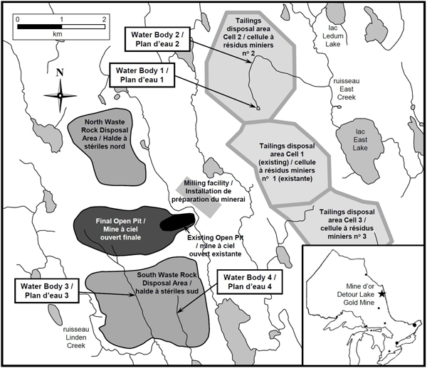
The Detour Lake Gold Mine is located approximately 145 km northeast of the town of Cochrane, Ontario, and 8 km west of the Ontario–Quebec border (see Figure 1). The mine is designed to process at least 55 000 tonnes of ore per day and is expected to operate for at least 16 years.
Mine production began in January 2013, and the mine consists of an open pit mine, an ore milling facility, and tailings and waste rock disposal areas as well as other associated infrastructure. It is expected that at least 350 million tonnes of tailings and at least 960 million tonnes of waste rock will be generated over the life of the mine. Beginning in 2019, the capacity of existing tailings and waste rock disposal areas will be exceeded, and the DGC is proposing to establish new and expanded disposal areas that would infill four natural, fish-frequented water bodies with tailings and waste rock. In order to allow the use of these four water bodies for waste rock and tailings disposal, the MMER would need to be amended to add the water bodies to Schedule 2 of the Regulations.
An environmental assessment of the project (comprehensive study) was undertaken under the former Canadian Environmental Assessment Act (CEAA) by the Canadian Environmental Assessment Agency (the Agency). (see footnote 1) The scope of the environmental assessment that was completed in December 2011 included the mine as currently built and operating, as well as the future establishment of new and expanded mine tailings and waste rock disposal areas. The Agency prepared the comprehensive study report in consultation with Fisheries and Oceans Canada, Natural Resources Canada, Environment Canada, Transport Canada, Health Canada and Aboriginal Affairs and Northern Development Canada. The comprehensive study report states that “taking into account the implementation of the mitigation proposed, including commitments made by the proponent in this report, the Canadian Environmental Assessment Agency concludes that the Project is not likely to cause significant adverse environmental effects.”
As part of the federal environmental assessment, alternatives for the future establishment of new and expanded tailings and waste rock disposal areas were assessed by the proponent. The assessment concluded that the use of these four water bodies for tailings and waste rock disposal is the preferred alternative based on the DGC's consideration of environmental, technical and socioeconomic impacts. Fisheries and Oceans Canada and Environment Canada accepted the DGC's conclusions and took them under consideration in the development of the comprehensive study report.
Objectives
The objective of the proposed Amendments is to allow the DGC to utilize four natural, fish-frequented water bodies for disposal of waste rock and tailings from the Detour Lake Gold Mine. The proposed Amendments follow a thorough assessment of alternatives that demonstrated that the use of the water bodies is the best option from an environmental, technical and socio-economic perspective.
Description
The proposed Amendments
The proposed Amendments would add a pond and portions of three creeks to Schedule 2 of the MMER. These are all natural, fish-frequented water bodies. This addition would allow disposal of waste rock and tailings from the Detour Lake Gold Mine into these water bodies. It is expected that the infilling of these water bodies with tailings and waste rock would not begin until about 2019. All effluent from these disposal areas would be subject to the requirements of the MMER. The proposed Amendments would come into force on the day on which they are registered.
The proposed expansion of the tailings disposal area would infill the following natural, fish-frequented water bodies (Figure 1):
- Water Body 1: an unnamed headwater pond of an unnamed tributary of East Creek (item 20 in the proposed legal text); and
- Water Body 2: a portion of an unnamed tributary of East Creek, which originates from Water Body 1 (Item 21 in the proposed legal text).
The proposed new waste rock disposal area to be established in 2019 would infill the following natural, fish-frequented water bodies (Figure 1):
- Water Body 3: a portion of an unnamed tributary of Linden Creek (Item 22 in the proposed legal text); and
- Water Body 4: a portion of an unnamed tributary of an unnamed lake in the Linden Creek watershed (Item 22 in the proposed legal text).
Figure 1: The Detour Lake Gold Mine and the water bodies that would be infilled by tailings and waste rock
The Detour Lake Gold Mine
In 2007, the project proponent, the DGC, began exploring the previously developed Detour Lake property. The property is located in northeastern Ontario, approximately 145 km northeast of the town of Cochrane and 8 km west of the Ontario–Quebec border (Figure 1). The property is located within the overlapping traditional territories of the Moose Cree First Nation (MCFN), the Taykwa Tagamou Nation (TTN), the Wahgoshig First Nation (WFN) and the Métis Nation of Ontario (MNO).
The Detour Lake deposit was discovered in 1974 and an open pit and underground mine were operated on the site from 1983 to 1999 by other mining companies: Campbell Red Lake Mines, Placer Dome and Pelangio Mines Inc. At the start of construction of the current Detour Lake Gold Mine, infrastructure remaining from the previous operation included a flooded 20 ha open pit and underground workings, 55 ha of waste rock disposal areas, a 275 ha tailings disposal area, related site roads and an airstrip. Other infrastructure had been removed as part of the previous reclamation of the site.
The DGC began construction of the Detour Lake Gold Mine in 2010, and the mine entered production in January 2013. The Detour Lake Gold Mine is an open pit gold mine with a production capacity of at least 55 000 tonnes per day and a life of at least 16 years. It should be noted that at the time of the environmental assessment, the DGC was anticipating a life of 16 years for the mine. Ongoing exploration activities have extended the anticipated life of the mine to at least 21.5 years, which would result in increased amounts of both tailings and waste rock. However, a review of the DGC's October 2012 production plan (see footnote 2) indicates that this life extension would not impact the footprint of the tailings and waste rock disposal areas, so there would be no additional direct impact on Water Bodies 1 through 4.
The DGC estimates that the deposit contains an ore reserve of 8.8 million ounces of gold. A financial analysis of the mine as reported by the DGC has forecast a net present value for the project of $1.66 billion before tax and $1.12 billion after tax (using a 5% discount rate). This represents an internal rate of return (IRR) of 14.2% before tax and 12.4% after tax. (see footnote 3)
The mining project is also expected to benefit Canadians, especially local communities, in the form of employment, business, and training opportunities. Local communities have expressed strong support, particularly the town of Cochrane. As of 2006, overall employment rates in the local communities were lower than the provincial averages, with much of the population within the project area traditionally relying on resource extraction activities related to forestry and mining. The local economy has experienced some upheaval with the downturn in the forestry industry. The mining sector, therefore, represents an economic opportunity for skilled employment in the region. The construction phase of the project employed over 1 400 workers as of November 2012 with 400– 500 workers employed for the operation phase that started in 2013. (see footnote 4)
The mine includes
- an open pit mine (approximately 3 km long, 1 km wide and 650 m deep when fully developed);
- a milling facility to process ore;
- a waste rock disposal area north of the open pit, about 1.5 km by 1 km in size;
- a proposed waste rock disposal area south of the open pit, about 2.5 km by 1.5 in size, which can only be developed if the proposed Amendments are approved, with waste rock disposal expected to begin in about 2019; and
- a tailings disposal area east of the open pit, about 6.5 km by 1.5 km in size, consisting of three separate cells:
- Cell 1, which is based on the existing tailings disposal area from the previous Detour Lake Mine;
- The proposed Cell 2, immediately to the north of Cell 1, which can only be developed if the proposed Amendments are approved, with tailings deposition expected to begin in about 2019; and
- Cell 3, immediately to the south of Cell 1, which does not infill any natural, fish-frequented water bodies.
The mine also includes site access roads, a new airstrip, power transmission lines, an explosive factory and magazines, water management infrastructure, buildings, ancillary mine infrastructure, and associated activities. It is expected that at least 350 million tonnes of tailings and 960 million tonnes of waste rock will be generated over the life of the mine. At least 120 million tonnes of non-reactive waste rock will be re-used for mine site construction.
As described above, the DGC is currently depositing tailings in a tailings disposal area that consists of two adjoining cells. A third cell would be developed by 2019 if the proposed Amendments are approved. The DGC is treating the tailings in the processing plant to remove the cyanide from the gold extraction process, as well as metals, prior to disposal. Cyanide treatment uses the sulphur dioxide (SO2) / air treatment process, which is expected to reduce cyanide concentrations in the tailings to less than 1 mg/L. The treated tailings are transported to the tailings disposal area as slurry (a mixture of solids and water) through a pipeline from the plant site and discharged at the crest of the tailings dam.
Development of the planned Cell 2 of the tailings disposal area would result in the infilling of Water Bodies 1 and 2 with tailings. Water Body 1 is a pond with a surface area of approximately 0.6 ha which drains downstream to East Creek by way of Water Body 2. Fisheries and Oceans Canada determined that both water bodies are natural, fish-frequented water bodies.
The DGC is currently disposing of waste rock into a disposal area immediately to the north of the open pit, referred to as the north waste rock disposal area. When the capacity of this location is exceeded in 2019, the DGC is proposing to establish a new waste rock disposal area immediately south of the open pit, referred to as the south waste rock disposal area. These locations take advantage of natural topography and minimize transportation distances. The results of the DGC's geochemical characterization of the rock to be mined indicate that the bulk of the waste rock will be non–acid generating with a relatively low potential for metal leaching. Approximately 20% of the waste rock is expected to be potentially acid generating. All of the acid generating waste rock and a portion of the non–acid generating waste rock will be contained in the north waste rock disposal area. This waste rock disposal area will not infill any natural, fish-frequented water bodies.
Development of the south waste rock disposal area, expected to begin in 2019, is contingent upon approval of the proposed Amendments. This waste rock disposal area would infill Water Bodies 3 and 4, which are natural, fish-frequented water bodies. The south waste rock disposal area would contain non–acid generating waste rock. The potentially acid generating waste rock would continue to be deposited in the north waste rock disposal area throughout the life of the mine.
Proposed fish habitat compensation plan
The development and implementation of a fish habitat compensation plan is required in accordance with section 27.1 of the MMER, to offset the loss of fish habitat that would occur as a result of the use of Water Bodies 1 through 4 for tailings and waste rock disposal. It is also one of the mitigation measures identified in the comprehensive study report.
The development of Cell 2 of the tailings disposal area would result in the infilling of Water Bodies 1 and 2. Sampling of these water bodies has indicated that only one fish species, brook stickleback (Culaea inconstans), a small freshwater fish that grows to a length of about two inches, is present. The surface area of Water Body 1 is approximately 0.6 ha. The portion of Water Body 2 that would be infilled with tailings is approximately 2 200 m in length with an average width of about 1 m, giving a surface area of about 0.22 ha. The total area of fish-frequented water bodies to be infilled with tailings is approximately 0.82 ha.
Water Body 1 is a uniform open water area without an inlet or outlet channel and with submergent and emergent aquatic vegetation. The riparian area is roughly 80 m wide and is vegetated with ferns, low shrubs and lichen. The pond has a mean depth of 0.9 m and maximum depth of 1.5 m, with a bottom covered with organic debris. Water in the pond is slightly acidic with, at times, low dissolved oxygen levels.
The portion of Water Body 2 to be infilled with tailings consists of a low gradient drainage corridor with a wide flood plain (approximately 80 m) with diffuse, intermittent braided channels and isolated pools near the east side of the tailings disposal area. Vegetation throughout this corridor is low growing and very dense, dominated by speckled alder and tamarack. Where formed channels exist, they average 1.2 m wide and 0.5 m deep. Sediments consist mostly of detritus with some silt and muck.
The development of the south waste rock disposal area would result in the infilling of Water Bodies 3 and 4 with waste rock. Sampling of these water bodies has indicated that only two fish species are present. Burbot (Lota lota) was captured in Water Body 3, and brook stickleback (Culaea inconstans) was captured in Water Body 4. The effective wetted width of each stream is approximately 1 m and the length providing fish habitat is approximately 1.8 km and 0.7 km for Water Body 3 and 4, respectively. The total surface area to be infilled with waste rock is estimated to be 0.25 ha: 0.18 ha for Water Body 3 and 0.07 ha for Water Body 4.
Water Body 3 has no defined channel and is densely vegetated with ferns, sedges and low shrubs typical of the area. Pools have formed in some sections and there are limited areas of flow. Sediments consist of muck, silt and detritus, and it is thought that the stream freezes to the bottom during winter months. Water Body 3 provides limited fish habitat until it becomes more defined downstream of the proposed waste rock disposal area.
Water Body 4 is a diffuse channel with short sections of defined channel. Vegetation is consistent with that of Water Body 3. The drainage is intermittent and the water freezes to the bottom in winter. Fish habitat is limited until Water Body 4 becomes more defined downstream of the proposed waste rock disposal area.
In total, 1.07 ha of fish habitat would be lost as a result of the construction of Cell 2 of the tailings disposal area and the south waste rock disposal area. In order to meet MMER requirements, the DGC has developed a fish habitat compensation plan to offset the loss of fish habitat that would result from the use of Water Bodies 1 through 4 for tailings and waste rock disposal. (see footnote 5)Proposed fish habitat compensation measures include the following components:
- The construction of a pond in a wetland area just south of Ledum Lake (see Figure 1). This pond would emulate the habitat observed in Water Body 1, and would have a total area of 1.2 ha, with an average depth of 0.9 m and maximum depth of 1.5 m.
- This pond would be connected to Ledum Lake by an existing drainage feature.
- Should fish not colonize the constructed pond in a timely fashion via the existing drainage corridor, fish passage between the constructed pond and Ledum Lake would be enhanced.
The compensation measures have been designed to create fish habitat like that being infilled by the proposed waste rock and tailings disposal areas. It is expected that brook stickleback would colonize the constructed habitat via local bog/fen drainages and the compensation area would be vegetated with flora typical of the area. Given the muskeg nature of the area, water quality is not expected to deviate from what is typical for the immediate area.
The fish habitat compensation plan was developed with the objective of offsetting the expected habitat loss with new or enhanced fish habitat. The total direct fish habitat created or enhanced as a result of these measures would be equivalent to 1.2 ha, resulting in a net gain of 0.13 ha. Considering that the constructed habitat would be similar to the infilled habitat, the loss of habitat is expected to be completely offset by the compensation measures.
It should be noted that the fish habitat compensation plan has been finalized but has not yet received final approval by the Minister of Fisheries and Oceans. In accordance with the requirements of subsection 27.1(1) of the MMER, the final habitat compensation plan would need to be approved by the Minister of Fisheries and Oceans prior to the deposit of tailings or waste rock into these water bodies.
The DGC is required, under section 27.1, to implement the plan, monitor its implementation, take measures to verify the extent to which the plan's purpose has been achieved and provide financial security to ensure that proposed compensation works are completed.
Regulatory and non-regulatory options considered
As part of the federal environmental assessment of the Detour Lake Gold Mine, the DGC submitted reports on the assessments of alternatives for the disposal of tailings (see footnote 6) and waste rock (see footnote 7) to Fisheries and Oceans Canada and to Environment Canada in July 2011. These reports were necessary to assess alternatives to the use of natural fish-frequented water bodies for tailings and waste rock disposal associated with the proposed future establishment of new and expanded mine tailings and waste rock disposal areas. These reports considered four different options for tailings disposal, (see footnote 8) and three different options for waste rock disposal. Based on these assessments and considering environmental, technical and socio-economic impacts, the DGC has determined that the use of Water Bodies 1 and 2 for tailings disposal and Water Bodies 3 and 4 for waste rock disposal is the preferred alternative. Fisheries and Oceans Canada and Environment Canada reviewed both reports and accepted the DGC's conclusions.
Regulatory options for tailings disposal
Regulatory options involve the disposal of tailings in a manner that would result in direct impacts on one or more natural, fish-frequented water bodies, and would therefore require the water bodies to be added to Schedule 2 of the MMER for the option to be implemented as proposed.
The DGC identified two potential tailings disposal locations, which would represent different regulatory options. These two regulatory options were assessed in detail using a multiple accounts analysis (MAA) according to environmental, technical and socio-economic considerations or accounts, following the Guidelines for the Assessment of Alternatives for Mine Waste Disposal (2009) provided by Environment Canada. Within each of these accounts, quantifiable criteria or indicators were identified, against which the impacts and benefits of each option were assessed. In total, 53 separate indicators were assessed for each option: 17 were environmental (e.g. overall affected land footprint, impacts on aquatic plant and animal species, impacts on fish and their habitats), 16 were technical (e.g. containment structure designs, potential for increased tailings deposit capacity) and 20 were socio-economic (e.g. costs related to constructing, operating, and closing the tailings disposal area; impacts on Aboriginal land rights; impacts on other land uses).
The option designated as Tailings Option 1 was identified as the preferred option as it would have lower dam structures, provide optimal water management for both mine water and mill water, and incorporate the use of the existing tailings disposal area. The total cost of Tailings Option 1 would also be lesser than that of the other options. Estimated costs of the regulatory and non-regulatory options for tailings disposal are presented in Table 1.
| Tailings Disposal Option | Estimated Total Cost of Tailings Disposal (Undiscounted Millions, 2012 dollars)(see reference *) |
|---|---|
| Regulatory options | |
| Tailings Option 1: Develop new tailings cells both north and south of the existing tailings disposal area. | 449 |
| Tailings Option 2: Develop a new tailings cell north of the existing tailings disposal area. | 468 |
| Non-regulatory options | |
| Tailings Option 3: Develop a new cell south of the existing tailings disposal area. | 535 |
Reference *
Cost estimates received from the DGC on May 31, 2012
Tailings Option 1: Develop new tailings cells both north and south of the existing tailings disposal area — Preferred option
Tailings Option 1 would use and expand upon the existing tailings disposal area from the previous Detour Lake Mine, by adding tailings cells to the north and south of the existing tailings disposal area while avoiding existing fish-frequented water bodies to the extent possible. In this option, the dams of the existing tailings disposal area, designated as Cell 1, would be raised. A new cell, Cell 3, would be constructed immediately to the south of Cell 1, followed in 2019 by the construction of Cell 2, to the north of Cell 1.
Tailings Option 1 would have a larger footprint than Tailings Options 2 and 3 (described below), but would provide the necessary tailings disposal capacity with the use of lower tailings containment dams. This option would provide for greater operational flexibility with respect to water management (e.g. to be able to manage water from extreme precipitation events) and would provide a larger catchment for precipitation, reducing the need to take fresh water for use in ore processing. This option would also better integrate the management of tailings with the management of water pumped on an ongoing basis from the open pit (referred to as mine water). The other options would necessitate separate mine water management ponds. Tailings Option 1 also offers more possibility of expansion in the likely event of an extension of the life of the mine beyond 16 years.
As an outcome of the assessment of alternatives for tailings disposal, including the detailed assessment of the three tailings options against the 53 indicators used in the multiple accounts analysis, the DGC concluded that “the construction of on-land disposal cells immediately north (Cell 2) and south (Cell 3) of a historic [tailings disposal area], which would infill two natural, fish-frequented water bodies, is the most environmental [sic] acceptable option and is also the preferred option both on a technical and socio-economic basis.” In addition to the advantages of Tailings Option 1 described in the previous paragraph, this option scored higher in the technical account as it provides more tailings storage capacity, a preferable dam-to-tailings volume ratio, and a lower risk when compared to options with higher dams. It also scored higher in the socio-economic account due primarily to lower capital and operating costs, although the closure costs would be higher.
Tailings Option 2: Develop a new tailings cell north of the existing tailings disposal area
Tailings Option 2 would also use and expand upon the existing tailings disposal area. In this option, a new tailings cell would be constructed to the north of the existing tailings disposal area, so the expanded disposal area would operate with two cells rather than three, as with Tailings Option 1. Thus, tailings Option 2 would also impact Water Bodies 1 and 2. This option would have a smaller footprint compared with other options, but it would require higher containment dams than Tailings Option 1, which carries more risks. A separate mine water management pond would be required. Construction costs for Tailings Option 2 would also be higher than for Tailings Option 1.
Non-regulatory options for tailings disposal
Non-regulatory options would involve the disposal of tailings in a manner that would not directly impact a natural, fish-frequented water body. The DGC identified two potential tailings disposal area locations which would represent different non-regulatory options. One of these, the development of a new tailings disposal area west of the open pit, was rejected because no one location would have sufficient capacity, so more than one tailings disposal area would be needed, the pipelines from the ore milling facility to the tailings disposal area for tailings and water return would be much longer, costs would be higher, and effluent would be discharged into multiple water bodies.
The DGC assessed the remaining non-regulatory option, Tailings Option 3, in detail using the same multiple accounts analysis approach used for the detailed assessment of Tailings Options 1 and 2.
Tailings Option 3: Develop a new cell south of the existing tailings disposal area
Tailings Option 3 would also use and expand upon the existing tailings disposal area from the previous Detour Lake Mine. In this option, a new tailings cell would be constructed to the south of the existing tailings disposal area. Thus, as in Tailings Option 2, the expanded tailings disposal area would operate with two cells rather than three, as in Tailings Option 1. The area to the south of the existing tailings disposal area that would be affected by this option does not include any fish-frequented water bodies. Tailings Option 3 would have a smaller footprint compared to Tailings Options 1 and 2, but it would have the highest containment dams and the greatest construction costs of the three options assessed. The higher dams would pose a greater long-term risk. This option would also require a separate mine water management pond.
Regulatory options for waste rock disposal
The DGC identified three options for waste rock disposal, all of which would be regulatory options. No non-regulatory options were identified. None of these options were eliminated from further consideration through the preliminary screening process, and all three were assessed in detail using a multiple accounts analysis approach like that used for the detailed assessment of the tailings disposal options. The option designated as Waste Rock Option 1 was identified as the preferred option, as it would prevent impacts to permanent water bodies and aquatic habitat, allow for the optimal management of runoff and seepage, and have the smallest overall footprint. This option also has the shortest haul distance, which would reduce fuel consumption and emissions. The total cost of Waste Rock Option 1 would also be smaller than the other options.
Table 2 provides a synopsis of the estimated costs of the regulatory options for waste rock disposal that were assessed.
| Waste Rock Disposal Option | Estimated Total Cost of Waste Rock Disposal (Undiscounted Millions, 2012 dollars)(see reference *) |
|---|---|
| Waste Rock Option 1: North and south waste rock disposal areas | 500 million |
| Waste Rock Option 2: North waste rock disposal area and Area A | 1,190 million |
| Waste Rock Option 3: North waste rock disposal area, multiple disposal areas south of pit, and Area A | 925 million |
Reference *
Cost estimates received from the DGC on May 31, 2012
Waste Rock Option 1: North and south waste rock disposal areas — Preferred option
Waste Rock Option 1, the preferred option for waste rock disposal, is to develop waste rock disposal areas immediately to the north and south of the open pit (see Figure 2). These locations take advantage of the natural topography and minimize transportation distances, and maximize the use of land previously disturbed by the past mining operations on site. Potentially acid generating waste rock would be directed to the north waste rock disposal area, along with some non–acid generating waste rock. The remaining non–acid generating waste rock would be directed to the south waste rock disposal area, beginning in about 2019. Both waste rock disposal areas would be encircled with ditches to capture and collect surface drainage and seepage. Waste Rock Option 1 would have a smaller footprint than the other two options, but would result in the infilling of Water Bodies 3 and 4 within the footprint of the south waste rock disposal area. Due to the proximity of the open pit, this option would be less costly than the other two waste rock disposal options.
Waste Rock Option 2: North waste rock disposal area and Area A
Waste Rock Option 2 would involve directing all potentially acid generating waste rock to the north waste rock disposal area along with some non–acid generating waste rock, as in Waste Rock Option 1. The remaining non–acid generating waste rock would be directed to an area west of Deem Lake, referred to as Area A (see Figure 2). Both disposal areas would be encircled with ditches to capture and collect surface drainage and seepage, consistent with Waste Rock Option 1. Area A has the disadvantage of being further from the open pit, with resultant increases in haul distances, leading to higher fuel consumption rates. As a result, Waste Rock Option 2 would have the highest operating costs of the three options considered, and the highest air emissions of contaminants and greenhouse gases. Also, Area A is located where the DGC has constructed the explosive factory and an airstrip, which could not easily be moved to other locations within the project area. Waste Rock Option 2 would have a larger footprint than Waste Rock Option 1, although the footprint would be smaller than for Waste Rock Option 3. Some of the water bodies that would be within the footprint of Area A may be fish-frequented.
Figure 2: Potential waste rock disposal options
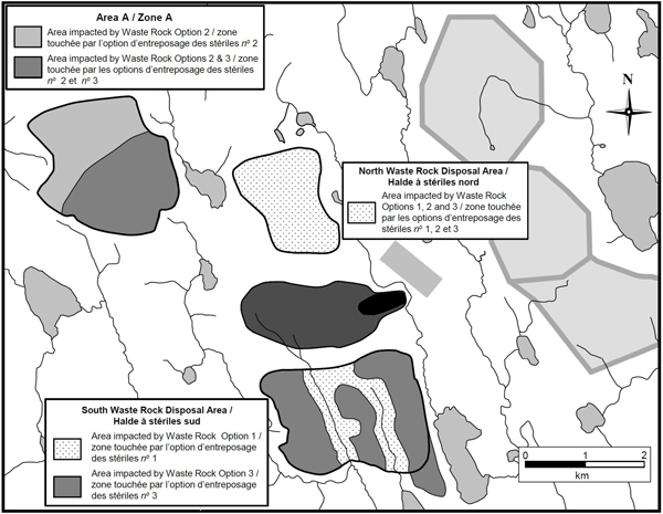
Waste Rock Option 3: North waste rock disposal area, multiple disposal areas south of the pit, and Area A
In Waste Rock Option 3, as in Waste Rock Options 1 and 2, all potentially acid generating waste rock and some non–acid generating waste rock would be directed to the north waste rock disposal area. Remaining non–acid generating waste rock would be directed to disposal areas south of the pit, but rather than one large disposal area, as in Waste Rock Option 1, there would be smaller disposal areas oriented to avoid Water Bodies 3 and 4. Once the capacity in this area is exhausted, remaining waste rock would be directed to Area A. All waste rock disposal areas would be encircled with ditches to capture and collect surface drainage and seepage. Waste Rock Option 3 would have the largest footprint of the three options considered, and due to the longer haul distances, operating costs and air emissions would be higher than for Waste Rock Option 1, although lower than for Waste Rock Option 2. The capture and collection of surface drainage and seepage would also be much more complex for this option compared to Waste Rock Options 1 and 2.
Benefits and costs
Summary
The proposed Amendments would allow the use of four fish-frequented water bodies for tailings and waste rock disposal. The listing of the four water bodies on Schedule 2 of the MMER would enable the effective disposal of tailings and waste rock from the Detour Lake Gold Mine beginning in approximately 2019 and allow the mine to be operated as proposed. To offset the loss of fish habitat that would occur as a result of using these water bodies for tailings and waste rock disposal the DGC would construct new fish habitat of approximately 1.2 ha, representing a net gain in fish habitat of 0.13 ha.
The non-monetized benefits of the proposed Amendments would be counterbalanced by the loss of the productive capacity of the four water bodies as fish habitat and wetland areas. While it is difficult to quantify and monetize the value of this loss, the analysis assigns a present value cost of $15,200 for water filtration and flood control and around $118,500 for the lost carbon storage over the analytical period of 25 years. The DGC would also incur an estimated cost of roughly $153,100 for implementation and monitoring of the fish habitat compensation plan. In total, the present value of the costs of the proposed Amendments is estimated to be around $286,800.
Given the expected increase in the size of fish habitat and the benefits of the use of these water bodies for the disposal of tailings and waste rock to the Detour Lake Gold Mine, the overall impact of the proposed Amendments is expected to be positive.
Analytical framework
The to cost-benefit analysis (CBA) identifies, quantifies and monetizes the incremental costs and benefits associated with the proposed Amendments to the extent practicable. The CBA framework applied to this study incorporates the following elements:
- Costs and benefits are expressed as present values in 2011 dollars over a 25-year time frame between 2013 and 2037. This time frame is chosen to account for the estimated life of the mine and mine closure, at which time the DGC plans to revegetate the tailings disposal area and portions of the waste rock disposal areas. Due to the uncertainty involved with the permanency of the ecological impacts following revegetation and the difficulty in quantifying this impact, the time frame is not extended beyond 2037. Where it is not possible to quantify these values, due either to lack of appropriate data or difficulties in valuing certain components, incremental impacts are evaluated in qualitative terms.
- A social discount rate of 3% is used in the analysis for estimating the present value of the costs and benefits. This level is within the range prescribed by the Treasury Board Secretariat's CBA guidelines.
- Impacts are analyzed in terms of incremental changes to costs and benefits for Canadian society. The incremental impacts are determined by comparing two scenarios: the business as usual (BAU) scenario and the regulatory scenario.
Business as usual scenario
The BAU scenario assumes that the proposed Amendments are not implemented and that the water bodies are not listed to Schedule 2 of the MMER. There is no disposal of tailings and waste rock into the water bodies, which continue to generate ecological goods and services throughout the analytical time frame. The DGC does not incur any costs for fish habitat compensation by triggering section 27.1 of the MMER, and the associated wetland areas is not converted to a pond with fish habitat.
Regulatory scenario
The regulatory scenario assumes that the water bodies are listed to Schedule 2 of the MMER and that new and expanded tailings and waste rock disposal areas will infill the four water bodies beginning in 2019. The water bodies will no longer generate ecological goods and services throughout the analytical time frame. The DGC incurs costs for fish habitat compensation and converts an associated wetland area into a pond with new fish habitat.
Table 3 summarizes the benefits and costs that are included within the analysis.
| Benefits | Costs |
|---|---|
Industry Enabling of effective disposal of tailings and waste rock and the operation of the mine as planned |
Industry Habitat compensation costs incurred by the DGC |
Canadians New fish habitat to compensate for loss of water bodies resulting in a net gain of 0.13 ha |
Canadians Loss of four water bodies in 2019:
|
Key assumptions
The proposed Amendments are a regulatory proposal pertaining to the use of the four water bodies for tailings and waste rock disposal and are not a regulatory approval of the entire mine. Therefore, the analysis does not take into account the overall costs and benefits of the Detour Lake Gold Mine (including the costs of constructing and operating the tailings and waste rock disposal areas), which has already undergone federal and provincial review and approval. In addition, the Detour Lake Gold Mine began commercial operations in January 2013 and is already subject to the effluent limits and other requirements of the MMER. Regulatory costs associated with these requirements are not considered incremental, aside from the requirement to compensate for the loss of fish habitat under section 27.1 of the MMER.
Benefits
Industry
The proposed Amendments would provide regulatory approval for the use of the four water bodies for tailings and waste rock disposal and would enable the effective management and disposal of tailings and waste rock from the Detour Lake Gold Mine when the capacity of existing tailings and waste rock disposal areas is reached beginning in 2019. This is an important component of the Detour Lake Gold Mine. Over the life of the mine it is expected that 350 million tonnes of tailings and 960 million tonnes of waste rock will be produced and will require appropriate disposal. It is challenging to isolate the specific value of this benefit as the use of the water bodies for tailings and waste rock disposal represents one component of a broader mine waste management plan and one in a series of reviews and approvals required for construction and operation of the mine as a whole to be undertaken. However, by allowing the use of the water bodies for tailings and waste rock disposal, the proposed Amendments would enable the operation of the mine as planned, helping to realize the economic benefits of the project.
Canadians
As required under section 27.1 of the MMER, the DGC has proposed a fish habitat compensation plan to offset the loss of fish habitat which would occur as a result of approval of the proposed Amendments. Habitat compensation measures would consist of the construction of a pond having a total area of approximately 1.2 ha, resulting in a net gain of fish habitat of approximately 0.13 ha. Considering that the nature of the constructed habitat would be similar to that of the infilled habitat, this compensation is expected to completely offset the loss of fish habitat of the four water bodies.
It should be noted that the pond constructed as part of the fish habitat compensation plan would be established in an existing wetland area. The assumption is made that the existing wetland area currently provides many of the ecological functions which would be lost elsewhere due to the proposed Amendments, with the exception of fish habitat. The incremental value of this net gain in fish habitat is difficult to monetize given the lack of recreational or commercial value associated with the brook stickleback.
Costs
Canadians
In total, 1.07 ha of fish habitat would be lost due to the infilling with tailings (approximately 0.82 ha) and waste rock (approximately 0.25 ha). These water bodies are located within Canada's boreal region and are categorized as a type of peatland (organic wetland). The water bodies contain a range of aquatic plants and two identified fish species, the brook stickleback and the burbot. No recreational activities and no significant cultural ties for the local Aboriginal communities have been associated with the water bodies. (see footnote 9) However, from a broader perspective, these water bodies provide a range of ecosystem services, including
- flood control and water filtering;
- habitat for fish (brook stickleback and burbot); and
- carbon storage.
The proposed Amendments would result in a loss of these ecological services with the construction, operation, and closure of Cell 2 of the tailings disposal area and the south waste rock disposal area. The analysis assumes that these water bodies and the ecological goods and services that are associated with them are lost beginning in 2019 with the infilling with tailings and waste rock. An analytical period of 25 years, from 2013 to 2037, was selected to adequately incorporate the value of this loss to society before revegetation provides some offset for the loss of ecosystem services associated with the loss of Water Bodies 1 to 4.
While not all of the ecological services can be quantified, due to a lack of available data, the analysis includes an assessment of the value of lost carbon storage and flood control and water filtering services. The value of flood control and water filtering services and the value of carbon storage of peatlands in Canada's boreal region have been assessed by Anielski and Wilson (2005), (see footnote 10) and a benefits transfer approach is used in the analysis to assign a value to the ecological costs of the proposed Amendments.
Flood control and water filtering
Wetlands are valued for their water filtration and water regulation services: they remove contaminants, suspended particles, and excessive nutrients, as well as serve as a reservoir to help control and reduce flooding. These services have value for agriculture, electricity generation, municipal water supplies, and habitat for fish and other wildlife species. Anielski and Wilson estimated that the value of this ecological service is $926 per ha per year ($1,183 in 2011 Canadian dollars). (see footnote 11) Based on this value, the annual cost of losing these ecosystem services due to the proposed Amendments is estimated to be roughly $1,300 per year, assuming an impacted area of 1.07 ha. The present value of these damages throughout the analytical period is estimated to be roughly $15,200.
The tailings and waste rock disposal areas and the associated infrastructure to capture and collect surface drainage and seepage from those disposal areas would provide flood control capacity, since there would be capacity to hold significant amounts of water for more gradual release. In addition, surface drainage and seepage that is captured would have to meet the effluent discharge limits specified in the MMER and would be treated as needed to meet these limits. Thus, the establishment of the tailings and waste rock disposal areas in place of Water Bodies 1 through 4 would offset the loss of flood control and water filtering functions currently provided by those water bodies. However, the scale of this offset has not been quantified and has not been accounted for in the estimated cost associated with the loss of these functions.
Carbon storage
Peatlands provide an invaluable service by capturing and storing carbon dioxide (CO2). Anielski and Wilson estimated that the value of this ecological service could range from $1,648 per ha to $13,137 per ha per year depending upon the value of carbon which is used in the analysis. The social cost of carbon (SCC) is used in the modeling of the cost-benefit analysis of environmental regulations in a regulatory impact analysis statement to quantify the benefits (or the cost) of reducing (or increasing) greenhouse gas (GHG) emissions. It represents an estimate of the economic value of avoided climate change damages at the global level for current and future generations as a result of reducing GHG emissions. The calculations of the SCC are independent of the method used to reduce emissions.
The preliminary recommendations, based on current literature and in line with the approach adopted by the U.S. Interagency Working Group on the Social Cost of Carbon, (see footnote 12) are that it is reasonable to estimate the SCC values at a central value of $28.44/tonne of CO2 in 2012 up to $61.85 in 2056, increasing at a given percentage each year associated with the expected growth in damages. (see footnote 13) EC's review also concludes that a value of $112.37/tonne in 2012 up to $243.96 in 2056 should be considered in our analysis, reflecting a 95th percentile and also arguments raised by Weitzman (2011) (see footnote 14) and Pindyck (2011) (see footnote 15) regarding the treatment of right-skewed probability distributions of the SCC in cost-benefit analyses. (see footnote 16) Their argument calls for full consideration of lowprobability, high-cost climate damage scenarios in cost-benefit analyses to more accurately reflect risk. A value of $112.37 per tonne does not, however, reflect the extreme end of the SCC estimates, as some studies have produced values exceeding $1,000 per tonne of carbon emitted.
Based on the work of Anielski and Wilson and after applying an SCC value of $28.44/tonne of CO2 in 2012, the value of carbon storage by the four water bodies is estimated to be around $6,700 per ha beginning in 2019. The loss of this ecosystem function beginning in 2019 would result in a total estimated cost to society of around $118,500 (present value) over the analytical time frame.
It should be noted that the pond that would be constructed as part of the fish habitat compensation plan would be established in an existing wetland area that currently provides a carbon storage function. Thus, it was assumed that the carbon storage provided by the constructed pond would not provide any offset for the loss of carbon storage associated with water bodies 1 to 4.
Industry
The proposed Amendments would result in some incremental costs to the DGC. As required under section 27.1 of the MMER, the DGC has proposed a fish habitat compensation plan to offset the loss of fish habitat. It is estimated that capital expenses to construct the pond and connections to Ledum Lake would have a cost of $116,300. Following construction of the pond and connections, the DGC would also incur operational costs to maintain the fish habitat, which has a present value of $36,800 over the analytical period. In total, the present value costs of capital and operating expenses are estimated to be around $153,100 over 25 years.
Government
The incremental costs to the Government of Canada would be negligible given that the Detour Lake Gold Mine is already subject to the effluent limits and other requirements of the MMER.
Cost-benefit statement
The results of the CBA are summarized in Table 4, with each impact presented in net present values where possible in the base year and final year of analysis. The values are discounted at 3% and are presented in terms of monetized impacts (carbon storage, water filtration and flood control, fish habitat compensation), non-monetized impacts (loss or gain of fish habitat), and qualitative impacts (effective tailings disposal beginning in 2019 and operation of the mine as planned). The total costs of the proposed Amendments are estimated to be around $286,800 (present value) from 2013 to 2037. These costs are offset by the creation of new fish habitat and the operation of the mine as planned, which is expected to bring positive economic benefits for society.
| Incremental Costs and Benefits | 2013 | 2019 | 2037 | Total 2013–2037 | Annualized Average |
|---|---|---|---|---|---|
| Monetized costs A. Societal costs |
|||||
| Carbon storage | 0 | 6,700 | 5,700 | 118,500 | 6,800 |
| Water filtration and flood control | 0 | 1,000 | 600 | 15,200 | 870 |
| B. Industry costs | |||||
| Fish habitat compensation | 116,300 | 0 | 0 | 153,100 | 8,800 |
| Total costs — with the SCC at $28 tonne in 2012 | 116,300 | 7,700 | 6,300 | 286,800 | 16,500 |
| Total costs — with alternate SCC at $112 tonne in 2012 | 116,300 | 26,000 | 21,600 | 607,700 | 34,900 |
| Quantified benefits A. Fish habitat |
|||||
| New fish habitat | 1.2 ha | 1.2 ha | 1.2 ha | 1.2 ha | N/A |
| Lost fish habitat | 0 | 1.07 ha | 1.07 ha | 1.07 ha | N/A |
| Net fish habitat | 1.2 ha | 0.03 ha | 0.03 ha | 0.03 ha | N/A |
| Qualitative and non-monetized impacts | |||||
| A. Industry | Enabling the use of water bodies for tailings and waste rock disposal for the Detour Gold Company beginning in 2019 allows the mine to proceed as planned | ||||
| B. Societal | Potential offset of the loss of water filtration and flood control functions by the collection of surface drainage and seepage from the tailings and waste rock disposal areas. | ||||
Reference *
Present value in 2011 Canadian dollars, using a 3% discount rate. Due to rounding, some of the totals may not match.
Sensitivity analysis
A sensitivity analysis was conducted on key variables to test the impacts of uncertainty on the results. While it is recognized that the proposed Amendments would result in a net gain of fish habitat, the analysis does not include monetized benefits and it was not possible to arrive at a net present value for the proposed Amendments. Therefore, the sensitivity analysis determines how total costs would vary when changing one variable at a time while holding all other variables constant. The following variables were changed in the sensitivity analysis.
- The discount rate was varied between 7% and no discount to determine how sensitive the costs are to the selection of the discount rate.
- The analytical time frame was extended outwards to 50 years (2063), which allows for further consideration of ecological costs while assuming that revegetation has no impact on restoring the wetlands.
The results of the sensitivity analysis, summarized in Table 5, show that relative to the non-monetized benefits, the total present value costs of the proposed Amendments would increase to $370,200 when using a 7% discount rate and to $411,100 when using a 50-year analytical period. Extending the analytical time frame to 50 years shows that even in a scenario in which no rehabilitation is assumed, the costs of the proposed Amendments remain low. In all scenarios, the total costs would remain below $500,000.
| Sensitivity Variables | Total Cost | ||
|---|---|---|---|
| Lower | Central | Upper | |
| 1. Sensitivity to discount rates (undiscounted; 3%; 7%) | 226,000 | 286,800 | 370,200 |
| 2. Analytical time frame (25 years / 50 years) | N/A | 286,800 | 411,100 |
“One-for-One” Rule
The “One-for-One” Rule does not apply to the proposed Amendments, which do not place any incremental administrative burden upon the DGC. The proposed Amendments would impact the Detour Lake Gold Mine, which is already subject to the effluent limits and other requirements of the MMER that were triggered by construction activities already undertaken.
Small business lens
The small business lens does not apply to this proposal, as there are no costs to small business. The proposed Amendments would impact the Detour Lake Gold Mine, owned and operated by the Detour Gold Corporation, which is not a small business.
Consultation
In November 2011, Environment Canada and Fisheries and Oceans Canada (DFO) held two consultation sessions, one in Cochrane, Ontario, and the other in Ottawa, Ontario. These consultation sessions took place during the public comment period related to the environmental assessment comprehensive study report prepared by the Canadian Environmental Assessment Agency. The objective of these consultation sessions was to provide stakeholders an opportunity to comment on the proposed Amendments.
Participants in the Cochrane session included a small number of local residents and representatives of local Aboriginal groups and communities, the provincial government and the DGC. Participants in the Ottawa session included representatives of national Aboriginal organizations, environmental non-governmental organizations (ENGOs), and the mining industry, including the DGC.
Following the two consultation sessions, four written submissions were received: one from a local Aboriginal community, two from environmental organizations and one from the Mining Association of Canada.
In general, the Detour Lake Gold Mine is supported by the local community and the mining industry. Aboriginal communities potentially affected by the mine have been consulted and they support the project, as do the two national Aboriginal organizations that participated in the consultations. The ENGOs that participated in the consultations raised some concerns with respect to the assessment of alternatives, the fish habitat compensation plan and water quality.
The DGC consulted with local Aboriginal groups and communities, and impact and benefit agreements have been negotiated between the DGC and the Moose Cree First Nation (MCFN), the Taykwa Tagamou Nation (TTN), the Wahgoshig First Nation (WFN) and the Métis Nation of Ontario.
In addition to comments specific to the proposed Amendments, local Aboriginal groups also provided comments regarding aspects of the project as a whole, particularly about potential impacts on water quality and about the mine closure plan. The DGC and the provincial regulatory agencies responsible for authorization and mine closure are continuing to engage with local Aboriginal groups on these issues. For example, local Aboriginal groups have been engaged in the development of the detailed mine closure plan based on the conceptual closure plan presented during the environmental assessment. The comments beyond the scope of the proposed Amendments are not summarized here. Comments raised at the two consultation sessions and submitted in writing are summarized below.
Comments related to the assessment of alternatives for tailings and waste rock disposal
Representatives from ENGOs commented that there was insufficient opportunity to provide input on the development of the assessments of alternatives for tailings and waste rock disposal, including the multiple accounts analysis of the alternatives undertaken by the DGC. As well, some ENGOs stated that the consultations on the proposed Amendments should have been held sooner in the environmental assessment process.
Environment Canada noted that during the environmental assessment, the public was provided with three formal participation opportunities where they could bring forward comments or any concerns about the project. A draft of the assessment of alternatives for tailings disposal was available for comment. Environment Canada also conducted consultations on the proposed Amendments as per the Cabinet Directive on Regulatory Management.
Environment Canada also noted that the DGC followed the 2009 Guidelines for the Assessment of Alternatives for Mine Waste Disposal that does not include recommendations regarding early consultation on the alternatives assessment. The current (2011) version of the Guidelines for the Assessment of Alternatives for Mine Waste Disposal includes recommendations to proponents regarding early consultation on the alternatives assessment.
Proposed habitat compensation plan
Some ENGOs and national Aboriginal groups expressed concern about the lack of detailed commitments to monitoring in the proposed fish habitat compensation plan.
Environment Canada and DFO responded that the MMER require the development and implementation of a fish habitat compensation plan which has to be approved by the Minister of Fisheries and Oceans. In accordance with paragraphs 27.1(3)(e) and (f) of the MMER, the fish habitat compensation plan must describe measures to monitor the implementation of the plan and to verify the extent to which the plan's purpose has been achieved. Since the consultations were held, the fish habitat compensation plan, including the monitoring plans, has been finalized. Final approval by the Minister of Fisheries and Oceans is pending.
An ENGO commented on the lack of discussion of non–fish related values of the water bodies that would be affected by the project in the fish habitat compensation plan.
DFO indicated that the DGC was very close to completing the development of a detailed fish habitat compensation plan based on the conceptual plan presented as part of the environmental assessment. Fisheries and Oceans Canada indicated that local First Nations would be provided with a copy of the updated plan when it is available. As stated above, since the consultations were held, the fish habitat compensation plan has been finalized. Final approval by the Minister of Fisheries and Oceans is pending.
Regulatory cooperation
Federal departments, including Environment Canada, Fisheries and Oceans Canada and Natural Resources Canada, cooperated and collaborated in the preparation of the proposed Amendments. The Government of Ontario supports the proposed Amendments, which are consistent with its policies and programs.
Rationale
The proposed Amendments would allow the DGC to dispose of tailings and waste rock from the Detour Lake Gold Mine in four water bodies beginning in about 2019. In order to allow the use of these four natural, fish-frequented water bodies for tailings and waste rock disposal, the MMER would need to be amended to add these water bodies to Schedule 2 of the Regulations.
The mine is expected to generate benefits for the Canadian economy. The DGC estimates that the deposit contains an ore reserve of 8.8 million ounces of gold and forecasts a net profit for the project of $1.12 billion after tax. There will also be many associated benefits for surrounding communities in the form of employment and training opportunities.
During consultations on the proposed addition of these water bodies to Schedule 2, there was support for the project and no significant opposition to the proposed Amendments by stakeholders. The Detour Lake Gold Mine is supported by the local community, including Aboriginal groups and communities whose rights or title could be affected by the project.
A cost-benefit analysis estimated that the total costs of the proposed Amendments would be about $286,800 (present value) from 2013 to 2037 due to the loss of flood control, water filtering and carbon storage functions provided by the water bodies that would be infilled, and the costs to the DGC of implementing the fish habitat compensation plan. To offset the loss of fish habitat that would occur as a result of the use of these water bodies for tailings and waste rock disposal, the DGC would also construct approximately 1.2 ha of new fish habitat, representing a net gain in fish habitat of 0.13 ha. In addition, the Detour Lake Gold Mine would proceed as planned with an effective option for tailings disposal beginning in 2019 when existing capacity is reached.
Given the expected costs and benefits, as well as the forecasted profits of the entire mining project, the proposed Amendments are expected to result in a positive outcome for Canadian society. Based on consideration of the above, it is proposed that the MMER be amended to add the four water bodies to Schedule 2, allowing their use for the disposal of tailings and waste rock from the Detour Lake Gold Mine.
Implementation, enforcement and service standards
The DGC would be informed of the proposed Amendments, and Fisheries and Oceans Canada would confirm the DGC's obligations with respect to section 27.1 of the MMER.
The Detour Lake Gold Mine is already subject to the MMER. The proposed Amendments would not impact the manner in which the MMER are enforced. Compliance with all provisions of the MMER is being enforced by Environment Canada in accordance with the Department's plans for enforcement, particularly for mines newly subject to the MMER. Fisheries and Oceans Canada would be responsible for enforcement of section 27.1. Compliance and enforcement activities are carried out in accordance with the “Compliance and Enforcement Policy for the Habitat Protection and Pollution Prevention Provisions of the Fisheries Act.” (see footnote 17)
Contacts
Mr. Chris Doiron
Manager
Mining Section
Mining and Processing Division
Industrial Sectors Directorate
Environment Canada
351 Saint-Joseph Boulevard
Gatineau, Quebec
K1A 0H3
Telephone: 819-953-1105
Fax: 819-994-7762
Email: Chris.Doiron@ec.gc.ca
Mr. Yves Bourassa
Director
Regulatory Analysis and Valuation Division
Environment Canada
10 Wellington Street, 25th Floor
Gatineau, Quebec
K1A 0H3
Telephone: 819-953-7651
Fax: 819-953-3241
Email: RAVD.DARV@ec.gc.ca
PROPOSED REGULATORY TEXT
Notice is given that the Governor in Council, pursuant to subsection 36(5) of the Fisheries Act (see footnote a), proposes to make the annexed Regulations Amending the Metal Mining Effluent Regulations.
Interested persons may make representations with respect to the proposed Regulations within 30 days after the date of publication of this notice. All such representations must cite the Canada Gazette, Part I, and the date of publication of this notice, and be addressed to Chris Doiron, Manager, Mining and Processing, Industrial Sectors Directorate, Environment Canada, Gatineau, Quebec K1A 0H3.
Ottawa, January 28, 2014
JURICA ČAPKUN
Assistant Clerk of the Privy Council
REGULATIONS AMENDING THE METAL MINING EFFLUENT REGULATIONS
AMENDMENT
| Item | Column 1 Water or Place |
Column 2 Description |
|---|---|---|
| 20. | The unnamed headwater pond of an unnamed tributary of East Creek, Ontario | An unnamed headwater pond of an unnamed tributary of East Creek, located at 50°02′17″ north latitude and 79°40′57″ west longitude, approximately 145 km northeast of the town of Cochrane, Ontario. |
| 21. | A portion of an unnamed tributary to East Creek, Ontario | A portion of an unnamed tributary to East Creek, Ontario, located approximately 145 km northeast of the town of Cochrane, Ontario. More precisely, a 2.3-km portion of the tributary extending northwards and downstream from the outlet of the unnamed headwater pond referred to in item 20, to the centre of a dam constructed at 50°02′43″ north latitude and 79°40′20″ west longitude. |
| 22. | A portion of an unnamed tributary to Linden Creek, Ontario | A portion of an unnamed tributary to Linden Creek, Ontario, located approximately 145 km northeast of the town of Cochrane, Ontario. More precisely, a 1.8-km portion of the tributary extending southwards and downstream from the northern perimeter of a waste rock disposal area at 50°00′17″ north latitude and 79°43′37″ west longitude to the southern perimeter of the waste rock disposal area at 49°59′30″ north latitude and 79°43′07″ west longitude. |
| 23. | A portion of an unnamed tributary to an unnamed lake in the Linden Creek watershed, Ontario | A portion of an unnamed tributary to an unnamed lake in the Linden Creek watershed, Ontario, located approximately 145 km northeast of the town of Cochrane, Ontario. More precisely, a 1.4-km portion of the tributary extending southwards and downstream from the headwaters of the tributary at 50°00′17″ north latitude and 79°42′39″ west longitude to the southern perimeter of a waste rock disposal area at 49°59′25″ north latitude and 79°42′27″ west longitude. |
COMING INTO FORCE
2. These Regulations come into force on the day on which they are registered.
[6-1-o]